Grassy Island facts for kids

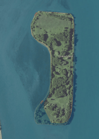
USGS aerial imagery of Grassy Island
|
|
| Geography | |
|---|---|
| Location | Detroit River |
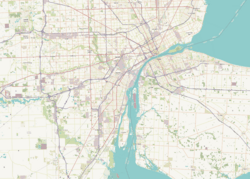
| Coordinates | 42°13′21″N 83°08′05″W / 42.22250°N 83.13472°W |
| Area | 72 acres (29 ha) |
| Administration | |
| State | |
| County | Wayne County |
| City | Wyandotte |
| Demographics | |
| Population | Uninhabited |
Grassy Island is a small, empty island in the Detroit River in the United States. It covers about 72 acres. This island is located near Grosse Ile and Fighting Island. It is also close to the border with Canada.
Grassy Island is part of the city of Wyandotte in Wayne County. It is also part of the Detroit River International Wildlife Refuge. It's important not to mix up Grassy Island with Grass Island, which is on the Canadian side of the Detroit River.
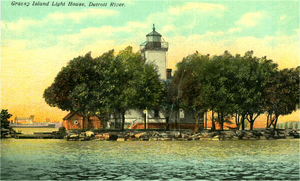
French explorers first mapped Grassy Island in 1796. They called it Ile Marecageuse, which means "Marshy Island." Back then, the island was only six acres big. The whole Detroit River area was a large wetland. For a long time, people used the island for fishing. Later, a lighthouse called the Grassy Island Light was built there.
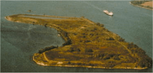
From around 1960 to 1982, Grassy Island was used as a dumping ground. Millions of cubic meters of dirty soil were placed there. This soil came from dredging the nearby River Rouge. This process made the island much larger. Because of this, the island is still very polluted today.
How Grassy Island Grew
As the city of Detroit grew quickly in the 1900s, factories released a lot of pollution. This pollution ended up in the Detroit River. It caused serious harm to the river's plants and animals. The river became so polluted that the government had to step in.
In 1961, the U.S. Congress made Grassy Island and the area around it part of the Wyandotte National Wildlife Refuge. At the same time, more and larger ships were using the Detroit River. This meant that bigger shipping paths were needed.
The U.S. Army Corps of Engineers took over Grassy Island from 1960 to 1982. They used it to dump millions of cubic meters of dirt. This dirt was dug up from the nearby River Rouge to make the river deeper for ships. They built walls around Grassy Island to hold the dirt. Much of this dirt was very polluted from nearby factories.
When the digging project finished, Grassy Island had grown a lot. It went from its original 6 acres to 72 acres. Because of this huge growth, Grassy Island is now seen as an artificial island. There is almost nothing left of the original small island. The mouth of the River Rouge was changed to a new path. All the dirt from this new path was dumped on Grassy Island. No one paid attention to how much pollution was in the soil.
Today, the island looks and feels unnatural. Its sides are steep dirt walls that hold the island up. These walls can be dangerous for people trying to land boats or walk on the island.
Why Grassy Island is Polluted
Around 1960, when Grassy Island became a dumping site, many large factories were active. At least nine major industries, including the Ford River Rouge Complex, were dumping their waste into the River Rouge. This caused a huge amount of toxic waste to build up near the river's mouth. This was the exact place where the dirt for Grassy Island came from.
The soil dumped on Grassy Island was very polluted. It contained chemicals like polychlorinated biphenyl (PCBs) and polycyclic aromatic hydrocarbon (PAHs). It also had dangerous amounts of heavy metals, such as mercury and lead. These came from Detroit's factories, which had few rules about pollution for many years.
There is a thin layer of clean topsoil on Grassy Island. This means there is no immediate danger to people who might visit. However, public access to the island is not allowed, though this rule is not always followed. The island has lost most of its wildlife and plants. By 1982, 97% of the original wetlands around the Detroit River were gone.
The soil on Grassy Island contains 28 different pollutants. These levels are higher than what state and federal rules allow. Grassy Island has not been officially named a Superfund site. However, the Environmental Protection Agency (EPA) and other groups are using similar methods to clean it up. In 1994, the Department of the Interior started working on Grassy Island. They wanted to find ways to fix such dangerous sites. Today, experts are still checking if the pollutants in the soil are leaking into the Detroit River.
In 2001, the Wyandotte National Wildlife Refuge, including Grassy Island, became part of the new Detroit River International Wildlife Refuge. This allowed more government money to be used for cleaning up the river. Large areas of land have been set aside to help nature recover. Because of these efforts, much of the Detroit River has become cleaner. Many native animals and plants have started to return.
 | Jewel Prestage |
 | Ella Baker |
 | Fannie Lou Hamer |


