Great capes facts for kids
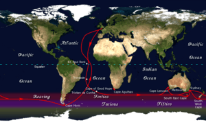
The great capes are three famous points of land at the southern tips of continents. They are very important for sailors. These capes are Africa's Cape of Good Hope, Australia's Cape Leeuwin, and South America's Cape Horn. They are known for their strong winds and rough seas.
Sailing the Great Capes
Sailors have used the great capes as important landmarks for a long time. The traditional clipper route was a sailing path that went south of these capes. This route used the strong winds of the "roaring forties." These winds are found between 40 and 50 degrees south latitude.
The great capes were very dangerous for ships. Because of this, they became famous spots in ocean travel. Even today, these capes are a big part of ocean yacht racing. Many races and sailors follow the old clipper route. Sailing around the world by passing these great capes is a huge achievement.
A famous sailor named Joshua Slocum was the first person to sail around the world alone. He did this between 1895 and 1898. The Joshua Slocum Society International gives an award to sailors who solo circumnavigate the world by passing the great capes.
The Five Southernmost Capes
Besides the three great capes, there are other important southern points of land. The five southernmost capes are the five points of land that are farthest south on Earth. These are either on mainlands or large islands.
Sailors who are sailing around the world often use these five capes as goals on their journey.
| Cape | Location | What Makes It Special |
|---|---|---|
| Cape Horn | Chile | This is on Hornos Island. It is the southernmost point of the Tierra del Fuego islands in South America. It is also the official dividing line between the Atlantic and Pacific oceans. |
| Cape Agulhas | South Africa | Its name means "Cape of Needles" in Portuguese. This is the southernmost point of Africa. It is the official dividing line between the Atlantic and Indian oceans. |
| West Cape Howe | Australia | This cape has three "heads." The easternmost one, Torbay Head, is the southernmost point of mainland Western Australia. |
| South East Cape | Australia | This is the southernmost point of the main island of Tasmania. |
| South Cape | New Zealand | This is the southernmost point of Stewart Island. It is the southernmost point of the main islands of New Zealand. |
See also
 In Spanish: Grandes cabos para niños
 | Mary Eliza Mahoney |
 | Susie King Taylor |
 | Ida Gray |
 | Eliza Ann Grier |


