
Greencastle, Missouri facts for kids
Quick facts for kids
Greencastle, Missouri
|
|
|---|---|

Location of Greencastle, Missouri
|
|
| Country | United States |
| State | Missouri |
| County | Sullivan |
| Area | |
| • Total | 0.45 sq mi (1.17 km2) |
| • Land | 0.45 sq mi (1.16 km2) |
| • Water | 0.00 sq mi (0.01 km2) |
| Elevation | 1,047 ft (319 m) |
| Population
(2020)
|
|
| • Total | 224 |
| • Density | 501.12/sq mi (193.52/km2) |
| Time zone | UTC-6 (Central (CST)) |
| • Summer (DST) | UTC-5 (CDT) |
| ZIP code |
63544
|
| Area code(s) | 660 |
| FIPS code | 29-29116 |
| GNIS feature ID | 2394981 |
Greencastle is a small city located in eastern Sullivan County, Missouri, in the United States. In 2020, the population was 224 people. It's a quiet community with a rich history.
Contents
History of Greencastle
Greencastle was officially planned out on March 12, 1857. This plan, called a plat, divided the land into blocks and lots. It was created by Victor Doze, Marion Overstreet, E.E. Prindle, I.E. Wood, and M.P. Wood.
Even before the town was planned, people lived in the area. The first permanent home was built around 1853 by Marion Sanders. A church, the Greencastle Methodist Episcopal Church, started holding services nearby in 1845.
The town grew steadily. In 1857, the Greencastle post office opened, with I.E. Wood as the first postmaster. Soon after, the first general store opened. A grist mill, which grinds grain, was built in 1879. A local newspaper, the Greencastle Independence, began publishing in 1881.
Greencastle officially became an incorporated town on August 8, 1881. This meant it could have its own local government. A train station for the Quincy, Missouri, and Pacific Railroad was built in 1883. By 1885, a creamery was making about 1,500 pounds of butter each week.
Geography and Location
Greencastle is situated on Missouri Route 6. It is about 13 miles east-northeast of Milan. It is also about 15 miles west of Kirksville.
A stream called Mussel Fork flows about one mile southwest of the city. The Union Ridge Conservation Area is two miles north. This area is located on Spring Creek.
The United States Census Bureau reports that Greencastle covers a total area of about 0.45 square miles (1.17 square kilometers). All of this area is land.
Population and People
| Historical population | |||
|---|---|---|---|
| Census | Pop. | %± | |
| 1880 | 191 | — | |
| 1890 | 267 | 39.8% | |
| 1900 | 390 | 46.1% | |
| 1910 | 454 | 16.4% | |
| 1920 | 487 | 7.3% | |
| 1930 | 376 | −22.8% | |
| 1940 | 342 | −9.0% | |
| 1950 | 287 | −16.1% | |
| 1960 | 250 | −12.9% | |
| 1970 | 235 | −6.0% | |
| 1980 | 285 | 21.3% | |
| 1990 | 254 | −10.9% | |
| 2000 | 308 | 21.3% | |
| 2010 | 275 | −10.7% | |
| 2020 | 224 | −18.5% | |
| U.S. Decennial Census | |||
2010 Census Information
The census taken in 2010 showed that 275 people lived in Greencastle. There were 123 households and 71 families. The population density was about 611 people per square mile (235.9 per square kilometer).
Most of the people living in Greencastle were White (99.6%). A small number (0.4%) were from two or more races. About 1.5% of the population identified as Hispanic or Latino.
Out of the 123 households, about 27.6% had children under 18 living with them. About 42.3% were married couples. Some households (11.4%) had a female head of household with no husband. A small number (4.1%) had a male head of household with no wife. About 42.3% of households were not families.
Many households (39.0%) were made up of individuals living alone. About 24.4% of all households had someone aged 65 or older living by themselves. The average household had 2.24 people. The average family had 3.03 people.
The average age of people in the city was 44.1 years. About 23.3% of residents were under 18. About 22.5% were 65 years old or older.
Images for kids
-
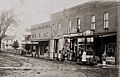
Part of the Greencastle business district in the 1890s.

See also
 In Spanish: Greencastle (Misuri) para niños
