Greene, Maine facts for kids
Quick facts for kids
Greene, Maine
|
|
|---|---|

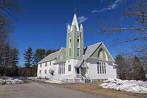
Greene Baptist Church
|
|

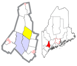
Location of Greene (in yellow) in Androscoggin County and the state of Maine
|
|
| Country | United States |
| State | Maine |
| County | Androscoggin |
| Incorporated | March 25, 1788 |
| Villages | Greene Greene Corner Nason Beach |
| Area | |
| • Total | 35.19 sq mi (91.14 km2) |
| • Land | 32.28 sq mi (83.60 km2) |
| • Water | 2.91 sq mi (7.54 km2) |
| Elevation | 335 ft (102 m) |
| Population
(2020)
|
|
| • Total | 4,376 |
| • Density | 135/sq mi (52.3/km2) |
| Time zone | UTC-5 (Eastern (EST)) |
| • Summer (DST) | UTC-4 (EDT) |
| ZIP code |
04236
|
| Area code(s) | 207 |
| FIPS code | 23-29255 |
| GNIS feature ID | 0582500 |
Greene is a town located in Androscoggin County, Maine, in the United States. In 2020, about 4,376 people lived there. Greene is part of the larger Lewiston-Auburn, Maine area. The main part of the town is known as the Greene census-designated place.
Contents
A Look Back: Greene's History
Greene was named after Nathanael Greene, an important general from the American Revolutionary War. The town officially became a town in 1788. This means it was given its own local government. Over the years, some land from Greene was given to nearby towns. For example, land was given to Lewiston in 1852 and to Webster (which is now called Sabattus) in 1895.
A famous person born in Greene was Aaron Daggett. He was born in 1837 and became a general in the American Civil War. He was the last surviving general from the Union Army.
Where is Greene?
Greene is located in the state of Maine. The United States Census Bureau says that the town covers a total area of about 35.19 square miles (91.14 square kilometers). Most of this area, about 32.28 square miles (83.60 square kilometers), is land. The rest, about 2.91 square miles (7.54 square kilometers), is water.
Who Lives in Greene?
| Historical population | |||
|---|---|---|---|
| Census | Pop. | %± | |
| 1790 | 375 | — | |
| 1800 | 933 | 148.8% | |
| 1810 | 1,277 | 36.9% | |
| 1820 | 1,309 | 2.5% | |
| 1830 | 1,324 | 1.1% | |
| 1840 | 1,406 | 6.2% | |
| 1850 | 1,348 | −4.1% | |
| 1860 | 1,224 | −9.2% | |
| 1870 | 1,094 | −10.6% | |
| 1880 | 999 | −8.7% | |
| 1890 | 885 | −11.4% | |
| 1900 | 826 | −6.7% | |
| 1910 | 773 | −6.4% | |
| 1920 | 670 | −13.3% | |
| 1930 | 784 | 17.0% | |
| 1940 | 865 | 10.3% | |
| 1950 | 974 | 12.6% | |
| 1960 | 1,226 | 25.9% | |
| 1970 | 1,772 | 44.5% | |
| 1980 | 3,037 | 71.4% | |
| 1990 | 3,661 | 20.5% | |
| 2000 | 4,076 | 11.3% | |
| 2010 | 4,350 | 6.7% | |
| 2020 | 4,376 | 0.6% | |
| U.S. Decennial Census | |||
In 2010, there were 4,350 people living in Greene. These people lived in 1,676 homes, and 1,246 of these were families. The town had about 134.8 people per square mile.
Most homes in Greene were families, with many being married couples living together. About 33.5% of homes had children under 18 living there. The average age of people in Greene was about 42.6 years old. About 22.6% of the residents were under 18 years old.
Learning in Greene
Greene is part of Maine School Administrative District #52, often called MSAD 52. This district includes several schools that serve students from Greene and nearby towns.
The schools in this district are:
- Turner Primary School
- Turner Elementary School
- Tripp Middle School
- Leavitt Area High School
- Greene Central School
- Leeds Central School
See also
 In Spanish: Greene (Maine) para niños
 | Calvin Brent |
 | Walter T. Bailey |
 | Martha Cassell Thompson |
 | Alberta Jeannette Cassell |


