Gregory Chapel facts for kids
Quick facts for kids Gregory Chapel (Archie Styrigg) |
|
|---|---|

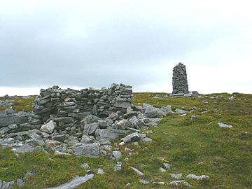
Cairn & sheep shelter, Gregory Chapel
|
|
| Highest point | |
| Elevation | 695 m (2,280 ft) |
| Prominence | ca 30 m |
| Parent peak | Great Shunner Fell |
| Listing | Nuttall |
| Geography | |
| Location | Mallerstang, Cumbria, England |
| Parent range | Pennines |
| OS grid | NY802003 |
| Topo map | OS Landranger 91 |
Gregory Chapel is a high point found on the hills, also known as "fells," that sit right on the border between two English counties: Cumbria and North Yorkshire. It's a place with interesting history and great views.
Contents
Exploring Gregory Chapel's Summit
The very top of Gregory Chapel has a few special features. You'll find a shelter for sheep nearby. There is also a unique pile of stones called a cairn. This cairn is taller and more rectangular than most others in the area. Some people think its unusual shape might be why this hill is called "Chapel."
Rocks and Views from the Top
The main type of rock you'll see around Gregory Chapel is limestone. However, on the very tops of the hills, you can also spot Millstone Grit rocks sticking out. From the summit, you get amazing views. You can look across the valley of Mallerstang to see Wild Boar Fell and Swarth Fell. These other fells are about 5 kilometers (3 miles) to the west.
What's in a Name? Gregory Chapel or Archy Styrigg
While maps call this hill Gregory Chapel, many people who walk in the hills prefer to use the name Archy Styrigg. It can be a bit confusing!
The Meaning of Archy Styrigg
The name Archy Styrigg appears on Ordnance Survey maps. It refers to a small, flatter area, or plateau, southwest of the summit. This plateau leads towards Mallerstang Edge. The name Archy Styrigg comes from the Norse language. This is common for names in this part of England. Sty means a track or path, and rigg means a ridge. So, Archy Styrigg likely means "the path along a ridge."
Gregory Chapel's Place Among Other Hills
Gregory Chapel is listed as a Nuttall and a sub-Hewitt. These are special lists for hills in England and Wales that meet certain height requirements. However, Gregory Chapel doesn't stand out much on its own. This is because it has a relatively small prominence. Prominence measures how much a peak rises above the land around it.
A High Plateau, Not a Single Peak
Gregory Chapel is part of a large, high, and often boggy area. This plateau rarely drops below 600 meters (2,000 feet) in height. It stretches between Mallerstang Edge and Great Shunner Fell, which is about 5.4 kilometers (3.4 miles) to the south-east.
The Three High Points of Mallerstang Edge
Gregory Chapel is one of three main high points along Mallerstang Edge. The other two are High Seat, which is about 1.04 kilometers (0.65 miles) almost directly north, and Hugh Seat, about 1.26 kilometers (0.78 miles) to the south-southeast. These three points mark the eastern edge of the Parish of Mallerstang in Cumbria. This line also forms the border between the counties of Cumbria and North Yorkshire.
Walking the Parish Borders
For hundreds of years, people have walked the borders of their local areas. This helped everyone know exactly where one parish ended and another began.
An Old Report from 1811
An old report from 1811 describes how the parish borders were walked in this area. It lists the important landmarks they visited:
- 12 As heaven water deals, to the south end of High seat
- 13 Thence over little Sleddle head to Gregory Chappell
- 14 Thence along Gregory band to a hurrock of stones
- 15 Thence to the height of Hugh Seat Morvill
- 16 Thence as heaven water deals, to the Skarth of Skaiths...
The phrase "as heaven water deals" is a charming old way of saying they followed a beck (a small stream) downstream. The parish borders were last walked in July 2006.
 | Jewel Prestage |
 | Ella Baker |
 | Fannie Lou Hamer |

