
Wild Boar Fell facts for kids
Quick facts for kids Wild Boar Fell |
|
|---|---|

The summit trig point
|
|
| Highest point | |
| Elevation | 2,323 ft (708 m) |
| Prominence | 1,129 ft (344 m) |
| Parent peak | Cross Fell |
| Listing | Marilyn, Hewitt, Nuttall |
| Geography | |
| Location | North Yorkshire/Cumbria, England |
| Parent range | Pennines |
| OS grid | SD757988 |
| Topo map | OS Landranger 98 |
Wild Boar Fell is a tall hill, also known as a fell, located in the beautiful Yorkshire Dales National Park in England. It stands on the eastern edge of Cumbria, near a place called Mallerstang. This impressive fell is about 2,323 feet (708 meters) high. It's one of the highest fells in the Yorkshire Dales, sometimes ranked as the 4th or 5th tallest, depending on how you count nearby hills.
Close to Wild Boar Fell is Swarth Fell, which is a ridge about one mile (1.5 km) long to the south. To the east, across a narrow valley, you can see High Seat and Hugh Seat.
Contents
The Story Behind the Name
Wild Boar Fell has an interesting history, especially when it comes to its name.
Why is it Called Wild Boar Fell?
Some people believe the fell got its name from wild boars that lived in this area over 500 years ago. These wild pigs were once common in England. However, it's a bit strange for an old Viking-settled area to lose its original Norse name. Many other local places, like The Nab and Dolphinsty, still have names from the Old Norse language.
In the late 1600s, Wild Boar Fell was sometimes called "Wilbright" or "Wilbert" fell in old records. This makes some people wonder if "Wild Boar" is truly the original name. Experts think the real name might come from the Old Norse language, just like many other features around it.
Old Industries on the Fell
Long ago, probably until the mid-1800s, the flat top of Wild Boar Fell was important for making millstones. These large, round stones were used to grind grain into flour. You can still see some partly finished millstones on the eastern side of the fell. You might also spot them on the western side of Mallerstang Edge, across the valley.
People also used sand from a small lake called Sand Tarn. This sand, made from the same rock as the millstones, was used to sharpen knives and tools like scythes (long blades for cutting grass). Locals would stick the sand onto wooden blocks with tar to make special sharpening tools called 'strickles'.
A Tusk and War Training
There's a tusk, said to be from "the last wild boar caught on the fell," kept in the church at Kirkby Stephen. It's a cool piece of local history!
During the Second World War, Wild Boar Fell was used by the British Army. Tank crews would train here at the Warcop Training Area to learn how to drive their tanks over tough, uneven ground.
Exploring Wild Boar Fell
Wild Boar Fell is a stunning sight and can be seen from many miles away.
How the Fell Looks
If you approach it from the north, Wild Boar Fell looks like a sharp, pointed peak. But if you see it from the south, near Aisgill, you'll notice its true shape. It looks a lot like Ingleborough, another famous hill, with steep sides and a flat top. This flat top is made of a type of rock called millstone grit.
Walking to the Top
A popular way to walk up Wild Boar Fell is by following a path from Hazelgill Farm. You walk west towards High Dolphinsty, then follow a ridge called Scriddles to Blackbed Scar. Once you reach there, you'll be on the flat, table-like top of Wild Boar Fell. It can be a bit wet and boggy up there!
The very top of the fell is marked by a trig point, which is a concrete pillar used for surveying. A small lake called Sand Tarn is about 330 yards (300 meters) to the west, just below the summit.
Amazing Views from the Top
The views from the summit are truly spectacular! You can see a huge panorama of the surrounding landscape. On a clear day, you can spot the Howgills, other parts of the Pennines, the distant Lake District fells, and the famous Yorkshire Three Peaks. If the weather is really good, you might even catch a glimpse of the sea at Morecambe Bay.
Mysterious Stone Men
A common sight on many fells in the Pennines and Lake District are groups of cairns. These are piles of stones built by people. There's a wonderful collection of these "stone men" on a part of Wild Boar Fell called The Nab. There's also a smaller group on a nearby, lower peak called Little Fell, which is about 1.25 miles (2 km) to the north.
No one is completely sure why or when these cairns were built. Some people think shepherds built them to mark paths, which might explain some of the simpler stone piles. But the larger, more organized groups, like those on The Nab, seem to need a more interesting explanation!
-
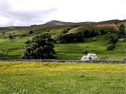
Wild Boar Fell, seen from Mallerstang in June, with wild flowers in the hay meadows
-
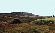
The table top profile of Wild Boar Fell, from Aisgill
-
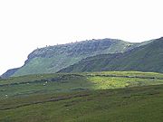
The Nab, Wild Boar Fell
-
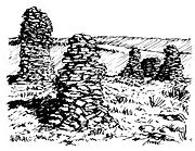
Cairns on The Nab, Wild Boar Fell


