Swarth Fell facts for kids
Quick facts for kids Swarth Fell |
|
|---|---|

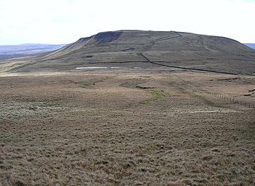
Swarth Fell from Wild Boar Fell
(Photo by John Illingworth) |
|
| Highest point | |
| Elevation | 681 m (2,234 ft) |
| Prominence | 76 m (249 ft) |
| Parent peak | Wild Boar Fell |
| Listing | Hewitt, Nuttall |
| Geography | |
| Location | Mallerstang, Cumbria, England |
| Parent range | Pennines |
| OS grid | SD7557596660 |
| Topo map | OS Landranger 98 |
Swarth Fell is a cool mountain in northern England. It stretches for about 1.5 kilometers (1 mile). This mountain is mostly made of limestone with a cap of millstone grit.
Swarth Fell is located just south of Wild Boar Fell. It's like a continuation of that bigger mountain. Most of Swarth Fell is in a place called Mallerstang in Cumbria. However, the border between Cumbria and North Yorkshire runs right along the mountain.
The highest point of Swarth Fell is 681 meters (2,234 feet) high. You'll find a pile of stones, called a cairn, marking the very top. This summit is listed as both a Hewitt and a Nuttall. These are special lists of mountains that meet certain height requirements.
The summit of Swarth Fell is about 2.1 kilometers south of Wild Boar Fell's summit. Between the two mountains, there's a low area called a col. Here, you can see more cairns and a small, unnamed tarn, which is a small mountain lake.
What's in a Name?
The name "Swarth" comes from an old language called Norse. In Norse, "svartr" means "dark." So, "Swarth Fell" basically means "Dark Mountain." Many places in this area have names from Old Norse.
Other High Points
About 1 kilometer southeast of the main summit is another high point. It's called Swarth Fell Pike. This spot is 651 meters (2,136 feet) high.
Another mountain, Baugh Fell in the Yorkshire Dales, is about 5.3 kilometers to the southwest.
 | Tommie Smith |
 | Simone Manuel |
 | Shani Davis |
 | Simone Biles |
 | Alice Coachman |


