Gualala, California facts for kids
Quick facts for kids
Gualala
|
|
|---|---|

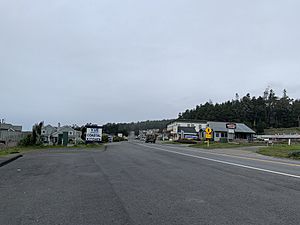
Street view of Gualala
|
|
| Country | United States |
| State | California |
| County | Mendocino |
| Elevation | 49 ft (15 m) |
| Population
(2010)
|
|
| • Total | 2,093 |
| • Median Age | 53.9 (male) / 51.8 (female) |
| Time zone | UTC-8 (Pacific) |
| • Summer (DST) | UTC-7 (PDT) |
| ZIP code |
95445
|
| Area code | 707 |
| FIPS code | 06-31428 |
| GNIS feature ID | 224701 |
Gualala (pronounced wə-LAH-lə) is a small community in Mendocino County, California. It is located on the Pacific coast where the Gualala River meets the ocean. You can find it along Highway 1.
Gualala is a place where people living nearby come to shop and get services. It used to be a town focused on logging (cutting down trees). Today, many people visit Gualala for fun, making tourism its main business.
Contents
What's in a Name?
The name Gualala comes from the Kashaya Pomo language. The original word was Qh awála-li, which means "where the water goes down."
The Spanish later spelled it as Gualala. You might sometimes see older spellings like Walhalla or Wallala.
A Look at Gualala's History
Early Native Peoples
The first people to live in this area were Native Americans known as the latcupda. They were a smaller group of the Pomo people.
Mexican Era and Land Claims
In the early 1800s, both the Spanish and Russians tried to settle in northern California. However, not many people moved into this specific area until the 1840s.
In 1844, a governor named Manuel Micheltorena gave a large piece of land (about 62.5 square miles) to General Rafael Garcia. This land was between the Gualala River and Mal Paso Creek. Garcia used it to let his cattle graze.
After the Mexican-American War, Mexico lost California to the United States. The U.S. government then looked at Garcia's claim to the land. In 1854, they decided his claim wasn't valid because of a small mistake. This meant the land became available for sale to the public.
The Lumber Industry
Cyrus D. Robinson and his family were some of the first American settlers to build homes on this land. By 1862, Robinson sold some of his land to Webber and Rutherford. They built a lumber mill in a place called China Gulch, near the Gualala River.
The town of Gualala quickly grew to support the mill. The mills cut down redwood trees from nearby forests. In 1868, Zemri Heywood and Samuel Harmon bought the mill. They built a second, larger mill near the mouth of the Gualala River. This mill, known as Heywood's Mill, was very important to Gualala's economy for about 40 years. At its busiest, it could produce 175,000 board feet of lumber every day! Sadly, Heywood's Mill burned down in a fire on September 14, 1906.
Moving the Lumber
At first, lumber was moved by draft horse teams and a wide railway to a special chute. This chute loaded the lumber onto ships. Later, a very wide railroad (68.5 inches wide!) replaced the horses.
After 1872, a safer place called Bourn's Landing (pronounced "bones") became the main shipping spot. The railroad was extended there. Most goods came through Bourn's Landing until cars became common in the early 1920s.
Town Growth and Development
In 1861, Cyrus Robinson officially claimed much of the land where Gualala is today. Soon, a hotel, a saloon, and a ferry were built. Robinson also managed the post office, which was also a stop for stagecoaches and the Wells Fargo Express.
By the late 1800s, Gualala was a busy center for the whole area. It even had a dancing school, a brass band, and an opera house!
The original hotel burned down in 1903. A new hotel was built south of the old spot. In 1907, Mark Pedotti and Antonio Ciapusci bought the Gualala Hotel property, which included 636 acres. Antonio's son George and his wife Ida later inherited the land.
Today, Gualala provides services for tourists visiting nearby Sea Ranch, California.
Gualala's Climate
Gualala has a warm-summer Mediterranean climate. This means it has warm, dry summers and mild, wet winters.
| Climate data for Gualala / Sea Ranch (1980-2016) | |||||||||||||
|---|---|---|---|---|---|---|---|---|---|---|---|---|---|
| Month | Jan | Feb | Mar | Apr | May | Jun | Jul | Aug | Sep | Oct | Nov | Dec | Year |
| Mean daily maximum °F (°C) | 56.5 (13.6) |
59.7 (15.4) |
61.5 (16.4) |
64.5 (18.1) |
67.5 (19.7) |
71.0 (21.7) |
73.0 (22.8) |
74.0 (23.3) |
72.8 (22.7) |
68.3 (20.2) |
61.3 (16.3) |
56.0 (13.3) |
65.5 (18.6) |
| Mean daily minimum °F (°C) | 42.0 (5.6) |
43.7 (6.5) |
45.0 (7.2) |
46.3 (7.9) |
48.8 (9.3) |
50.8 (10.4) |
51.0 (10.6) |
51.0 (10.6) |
50.8 (10.4) |
48.0 (8.9) |
45.7 (7.6) |
42.0 (5.6) |
47.1 (8.4) |
| Average precipitation inches (mm) | 6.5 (170) |
6.4 (160) |
4.73 (120) |
2.2 (56) |
1 (25) |
0.33 (8.4) |
0.05 (1.3) |
0.08 (2.0) |
0.43 (11) |
1.98 (50) |
4.5 (110) |
6.56 (167) |
34.76 (880.7) |
| Average precipitation days | 13 | 10 | 12 | 7 | 4 | 1 | 0 | 1 | 2 | 4 | 10 | 12 | 76 |
| Source 1: weatherspark | |||||||||||||
| Source 2: bestplaces.net | |||||||||||||
Education in Gualala
For a long time, there were no schools in Gualala. Before 1883, it was common for children to live with other families in bigger towns just to go to school.
In 1883, a single-room schoolhouse was built with help from the Heywood family.
Today, elementary school students from Gualala go to Horicon Elementary School in Annapolis or Arena Union Elementary in Point Arena. High school students attend Point Arena High School.
 | Jackie Robinson |
 | Jack Johnson |
 | Althea Gibson |
 | Arthur Ashe |
 | Muhammad Ali |


