
Guatavita facts for kids
Quick facts for kids
Guatavita
|
|||
|---|---|---|---|
|
Municipality and town
|
|||

Coliseum of Guatavita
|
|||
|
|||

Location of the municipality and town of Guatavita in the Cundinamarca Department of Colombia
|
|||

Guatavita
Location in Colombia
|
|||
| Country | |||
| Department | |||
| Province | Guavio Province | ||
| Founded | 18 March 1593 | ||
| Founded by | Miguel de Ibarra | ||
| Area | |||
| • Municipality and town | 247.3 km2 (95.5 sq mi) | ||
| • Urban | 6.84 km2 (2.64 sq mi) | ||
| Elevation | 2,680 m (8,790 ft) | ||
| Population
(2015)
|
|||
| • Municipality and town | 6,898 | ||
| • Density | 27.893/km2 (72.243/sq mi) | ||
| • Urban | 1,960 | ||
| Time zone | UTC-5 (Colombia Standard Time) | ||
| Website | Official website: http://www.guatavita-cundinamarca.gov.co/index.shtml#3 | ||


Guatavita is a town and municipality in Colombia. It is located in the Guavio Province of the Cundinamarca region. Guatavita is about 75 kilometers (47 miles) northeast of Bogotá, the capital city.
The town shares borders with Sesquilé and Machetá to the north. To the east are Gachetá and Junín. Guasca is to the south, and Tocancipá and Gachancipá are to the west.
Contents
A Look Back: Guatavita's History
Before the Spanish arrived, the area where Guatavita is now was home to the Muisca. They were an important group living on the Altiplano Cundiboyacense, a high plateau in the Colombian Andes mountains.
Ancient Muisca Traditions
Guatavita was led by a powerful chief called a cacique. This cacique was so important that even the main Muisca rulers, the zipas of Bacatá and the zaques of Hunza, would ask for his advice.
The Muisca people in Guatavita were very skilled at working with gold. They even built a special temple there to honor Sué, their Sun god.
The Golden Ceremony
The famous Lake Guatavita was a very sacred place for the Muisca. It was here that new zipa rulers were officially welcomed. The cacique of Guatavita led these important ceremonies. A famous golden art piece, the Muisca raft, shows how these rituals might have looked.
Around the year 1490, a big fight called the Battle of Chocontá happened. The zaque Michuá and the cacique of Guatavita joined forces. They had a large army of 60,000 guecha warriors. However, they lost to the zipa Saguamanchica. Both Muisca leaders died in this battle.
Modern Guatavita's Founding
The modern town of Guatavita was officially started on March 18, 1593. It was founded by a person named Miguel de Ibarra.
In the mid-1960s, the town of Guatavita had to be rebuilt. This happened because the Tominé Reservoir was being built. The old town area was going to be flooded on purpose by the new reservoir. So, the new Guatavita was built on higher ground.
What Guatavita Means
The name "Guatavita" comes from the Chibcha language of the Muisca people. It means "end of the farming fields" or "point of the mountain range."
How People Make a Living
The main ways people earn money in Guatavita are through agriculture (farming), mining, and tourism.
Farming and Local Products
In farming, the most common crops grown are potatoes, maize (corn), barley, and peas. These crops are important for the local economy.
Tourism and Crafts
Tourism is also a big part of Guatavita's economy, especially on weekends. Many visitors come to explore the town and buy unique items at the craft markets.
The Sacred Guatavita Lake
The very important and sacred Lake Guatavita is located close by. This lake was central to the ceremonies of the ancient Muisca. It is actually within the nearby Sesquilé municipality.
Climate
| Climate data for Guatavita, elevation 2,625 m (8,612 ft), (1971–2000) | |||||||||||||
|---|---|---|---|---|---|---|---|---|---|---|---|---|---|
| Month | Jan | Feb | Mar | Apr | May | Jun | Jul | Aug | Sep | Oct | Nov | Dec | Year |
| Mean daily maximum °C (°F) | 20.5 (68.9) |
20.6 (69.1) |
20.7 (69.3) |
20.1 (68.2) |
19.2 (66.6) |
18.1 (64.6) |
17.8 (64.0) |
18.3 (64.9) |
19.0 (66.2) |
19.5 (67.1) |
19.6 (67.3) |
19.7 (67.5) |
19.4 (66.9) |
| Daily mean °C (°F) | 13.7 (56.7) |
14.0 (57.2) |
14.4 (57.9) |
14.4 (57.9) |
14.3 (57.7) |
13.5 (56.3) |
13.1 (55.6) |
13.2 (55.8) |
13.5 (56.3) |
13.7 (56.7) |
13.9 (57.0) |
13.7 (56.7) |
13.8 (56.8) |
| Mean daily minimum °C (°F) | 8.6 (47.5) |
9.3 (48.7) |
10.2 (50.4) |
10.8 (51.4) |
10.8 (51.4) |
10.5 (50.9) |
10.2 (50.4) |
9.7 (49.5) |
9.4 (48.9) |
9.7 (49.5) |
10 (50) |
8.9 (48.0) |
9.8 (49.6) |
| Average precipitation mm (inches) | 32.0 (1.26) |
40.9 (1.61) |
65.2 (2.57) |
89.9 (3.54) |
78.7 (3.10) |
52.6 (2.07) |
50.0 (1.97) |
47.6 (1.87) |
53.8 (2.12) |
73.1 (2.88) |
58.8 (2.31) |
46.1 (1.81) |
688.6 (27.11) |
| Average precipitation days | 7 | 10 | 14 | 17 | 19 | 21 | 22 | 20 | 16 | 15 | 13 | 10 | 184 |
| Average relative humidity (%) | 74 | 74 | 76 | 79 | 79 | 79 | 78 | 78 | 78 | 79 | 78 | 76 | 77 |
| Source: Instituto de Hidrologia Meteorologia y Estudios Ambientales | |||||||||||||
Gallery
-
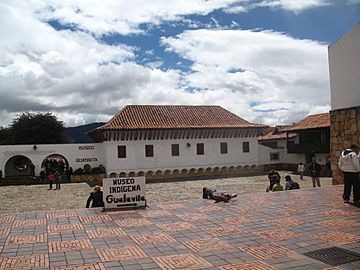
Central square of Guatavita
-
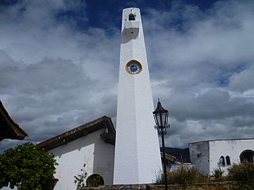
The Obelisk in Guatavita
-
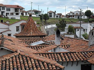
Typical white houses with red roofs
-
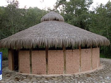
A reconstructed Muisca bohío (traditional house)


-
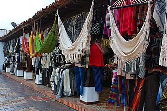
A vibrant crafts market in Guatavita
-
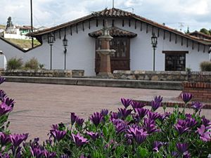
Beautiful flowers and a park area
-
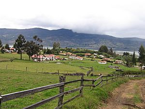
A view of the rural area around Guatavita
-
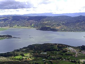
The Tominé Reservoir, which changed Guatavita
.jpg)


See also
 In Spanish: Guatavita para niños
