Gulkana River facts for kids
Quick facts for kids Gulkana River |
|
|---|---|

Gulkana River
|
|
|
Location of the mouth of the Gulkana River in Alaska
|
|
| Country | United States |
| State | Alaska |
| Census Area | Southeast Fairbanks, Valdez–Cordova |
| Physical characteristics | |
| Main source | Summit Lake Alaska Range, Southeast Fairbanks Census Area 3,806 ft (1,160 m) 63°14′29″N 145°28′03″W / 63.24139°N 145.46750°W |
| River mouth | Copper River 9 miles (14 km) northeast of Glennallen, Valdez–Cordova Census Area 1,302 ft (397 m) 62°13′15″N 145°23′34″W / 62.22083°N 145.39278°W |
| Length | 60 mi (97 km) |
| Basin features | |
| Basin size | 2,140 sq mi (5,500 km2) |
| Type: | Wild |
| Designated: | December 2, 1980 |
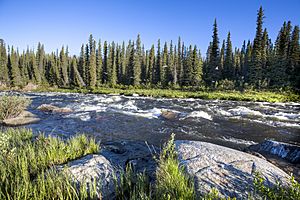
The Gulkana River is a beautiful river in Alaska, United States. It flows for about 60 miles (97 km). This river is a branch, or tributary, of the larger Copper River.
The Gulkana River starts near Summit Lake in the Alaska Range mountains. It then flows south. It joins the Copper River about 9 miles (14 km) northeast of Glennallen. The Richardson Highway and the Trans-Alaska Pipeline run close to the river. The river also passes under the Denali Highway near Paxson.
Contents
A Special "Wild" River
A large part of the Gulkana River and its smaller streams are very special. In 1980, about 181 miles (291 km) of these waterways were named "wild." This means they are part of the National Wild and Scenic Rivers System.
This special status helps protect the river's natural beauty. It also protects its amazing wildlife and plants. The Bureau of Land Management helps take care of these protected parts of the river.
Protected River Sections
The main part of the Gulkana River is protected for 47 miles (76 km). This section runs between Paxson Lake and a place called Sourdough. Other parts that are protected include:
- The north and south branches of the West Fork Gulkana River.
- The West Fork Gulkana River itself.
- The Middle Fork Gulkana River, from Dickey Lake to where it joins the main river.
Fun Things to Do on the Gulkana River
The Gulkana River area is a great place for outdoor adventures! It has many clear lakes and streams. It's known for having one of Alaska's best places to fish for grayling.
You can reach the river by car, plane, boat, or walking trails. The Gulkana River is home to many types of fish. These include:
The river flows through wild areas. You can see amazing views of the Wrangell Mountains. There are places to stay and services along the Richardson Highway.
Boating and Floating Adventures
The Gulkana River is popular for boating. People with different skill levels can enjoy it. Some parts of the river are easy to float. Others are very difficult. River difficulty is rated on a scale from Class I (easy) to Class IV (very difficult).
A trip down the main part of the Gulkana River can take four or five days. Trips starting on the smaller branches might take even longer. You can start or end your trip at several spots. These include Paxson Lake, Paxson Lake Campground, Sourdough Campground, Poplar Grove Campground, and the Richardson Highway Bridge at Gakona.
Floating the Middle Fork
Most trips on the Middle Fork Gulkana River start at the Delta National Wild and Scenic River Wayside. This is along the Denali Highway. These trips often include floating across lakes. You might also need to carry your boat over land in some spots. This is called a portage. You can also take a floatplane to Dickey Lake to start your adventure there.
Challenges on the West Fork
The West Fork Gulkana River and its two branches can also be floated. However, they are harder to reach and navigate. For example, the South Branch route has lakes and a part of the Tyone River. The portages on this route are very hard.
River Safety
When on the river, it's important to be safe. Some challenges you might face include:
- Canyon Rapids: These are on the main river and are rated Class III to IV (difficult to very difficult).
- Isolation: You might be far from help.
- Cold Water: The water is very cold.
- Logjams: Trees can block the river.
- Overhanging or Submerged Plants: Plants can get in the way.
- Portages: Carrying your boat can be tough.
- Powerboats: You might see powerboats on the lower part of the river.
Always be prepared and know the river conditions before you go!
 | Misty Copeland |
 | Raven Wilkinson |
 | Debra Austin |
 | Aesha Ash |


