Gundiah facts for kids
Quick facts for kids GundiahQueensland |
|||||||||||||||
|---|---|---|---|---|---|---|---|---|---|---|---|---|---|---|---|

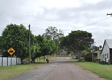
Main Street- looking towards the railway line. The Prince Alfred Hotel can be seen in the upper right.
|
|||||||||||||||
| Population | 89 (2021 census) | ||||||||||||||
| • Density | 1.604/km2 (4.15/sq mi) | ||||||||||||||
| Postcode(s) | 4650 | ||||||||||||||
| Area | 55.5 km2 (21.4 sq mi) | ||||||||||||||
| Time zone | AEST (UTC+10:00) | ||||||||||||||
| Location |
|
||||||||||||||
| LGA(s) | Fraser Coast Region | ||||||||||||||
| State electorate(s) | Gympie | ||||||||||||||
| Federal Division(s) | Wide Bay | ||||||||||||||
|
|||||||||||||||
Gundiah is a small country town in Queensland, Australia. It is located in the Fraser Coast Region. In 2021, only 89 people lived in Gundiah.
Contents
Where is Gundiah?
Gundiah is about 215 kilometers (134 miles) north of Brisbane. Brisbane is the capital city of Queensland.
The Mary River flows along Gundiah's western side. A mountain called Pine Mountain is also in the west. It rises to 123 meters (404 feet) above sea level.
The main railway line, called the North Coast railway line, runs through Gundiah. The town has its own train stop, called Gundiah railway station.
Most of the land in Gundiah is used for grazing. This means animals like cows eat the natural grass. Some areas also grow crops or have tree farms.
A Look at Gundiah's Past
The area where Gundiah is now was first known as "Gootchie". The name Gundiah comes from the Kabi language. It means goodbye.
The most important building in town is the Prince Alfred Hotel, which is a pub. The first hotel was built in 1868 but burned down. The pub you see today was built in 1947.
- The Gootchie Post Office opened in 1869.
- It changed its name to Gundiah Post Office in 1882.
- The post office closed in 1978.
- Gundiah railway station opened in 1882.
- Gundiah Provisional School first opened in 1886. It closed in 1895 but reopened in 1898.
- In 1909, it became Gundiah State School.
- The Gundiah Memorial Hall opened in 1922.
People Living in Gundiah
The number of people living in Gundiah has changed over the years:
- In 2006, there were 384 people.
- In 2016, the population was 123 people.
- In 2021, the population was 89 people.
What People Do in Gundiah
There are several large farms, called homesteads, in the Gundiah area:
- Banksia Ridge
- Evergreen
- Glencobie
- High View
- Ledsforth
Learning in Gundiah
Gundiah State School is a primary school for kids from Prep to Year 6. It is located at 23 Gundiah School Road.
- In 2017, 24 students went to the school. There were 3 teachers.
- In 2018, 28 students were enrolled. There were still 3 teachers.
There isn't a high school in Gundiah. Older students usually go to high schools in nearby towns. These include Maryborough State High School in Maryborough or James Nash State High School in Gympie.
 | Valerie Thomas |
 | Frederick McKinley Jones |
 | George Edward Alcorn Jr. |
 | Thomas Mensah |


