Hagen Peak facts for kids
Quick facts for kids Hagen Peak |
|
|---|---|

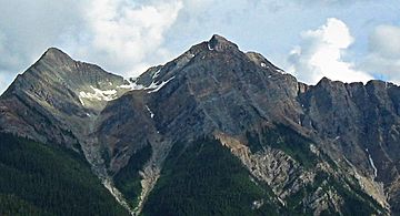
Hagen Peak, northwest aspect
|
|
| Highest point | |
| Elevation | 2,635 m (8,645 ft) |
| Prominence | 225 m (738 ft) |
| Geography | |
| Location | Yoho National Park British Columbia, Canada |
| Parent range | Park Ranges Canadian Rockies |
| Topo map | NTS 82N/10 |
| Geology | |
| Age of rock | Cambrian |
| Type of rock | Sedimentary |
Hagen Peak is a tall mountain in the Canadian Rockies, standing 2,635 meters (about 8,645 feet) high. It has a special feature called a double summit, meaning it has two main peaks close together. You can find this mountain on the western edge of Yoho National Park in British Columbia, Canada.
The mountain is located in the Blaeberry Valley, about 36 kilometers (22 miles) northeast of Golden. It's also less than 13 kilometers (8 miles) from the Continental Divide. The Continental Divide is like an imaginary line across North America where water on one side flows to the Pacific Ocean, and water on the other side flows to the Atlantic or Arctic Oceans.
Hagen Peak was named to honor a brave Canadian soldier, Alfred G. Hagen. He was from Field, British Columbia. Alfred Hagen was part of the 10th Canadian Infantry Brigade during World War II. Sadly, he died in 1944 while fighting to free Calais, France. The mountain officially received its name on July 5, 1961.
Mountain Weather
Hagen Peak experiences a subarctic climate. This means the area has very cold, snowy winters. Summers are usually mild, not too hot.
Temperatures on the mountain can drop below −20 °C (which is about -4 °F). With the wind, it can feel even colder, sometimes below −30 °C (-22 °F). Water from rain and melting snow, called precipitation runoff, flows in two main directions. Some water drains west into the Blaeberry River. Other water flows east into the beginning of the Amiskwi River.


