Haggart Lake (Cochrane District) facts for kids
Quick facts for kids Haggart Lake |
|
|---|---|
| Location | Cochrane District, Ontario |
| Coordinates | 49°13′18″N 81°43′28″W / 49.22167°N 81.72444°W |
| Type | lake |
| Part of | James Bay drainage basin |
| Primary inflows | Haggart Creek |
| Primary outflows | Haggart Creek |
| Basin countries | Canada |
| Max. length | 220 m (720 ft) |
| Max. width | 80 m (260 ft) |
| Surface elevation | 242 m (794 ft) |
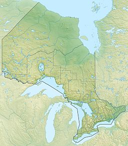
Haggart Lake is a small lake located in Ontario, Canada. It is found in the Cochrane District, which is in the northeastern part of the province. This lake is part of a very large area where all the water flows towards James Bay.
About Haggart Lake
Haggart Lake is a natural body of water. It is about 220 m (720 ft) long and 80 m (260 ft) wide. The lake sits at an elevation of about 242 m (794 ft) above sea level. It is located within Haggart Township.
Where is Haggart Lake?
The lake is in the Northeastern region of Ontario. This area is known for its many lakes and forests. Haggart Lake is a small part of Canada's vast natural landscape.
How Water Flows From Haggart Lake
Water is always moving, and Haggart Lake is no different. It has one main stream that both brings water in and takes water out. This stream is called Haggart Creek.
- Water flows into Haggart Lake from Haggart Creek at the south end.
- Water flows out of Haggart Lake through Haggart Creek at the north end.
After leaving Haggart Lake, Haggart Creek continues its journey. It flows into the Poplar Rapids River. From there, the water joins the Mattagami River. The Mattagami River then flows into the Moose River. Finally, the Moose River empties into James Bay. This whole system is called a drainage basin. It means all the rain and melted snow in this large area eventually ends up in James Bay.
 | Tommie Smith |
 | Simone Manuel |
 | Shani Davis |
 | Simone Biles |
 | Alice Coachman |


