
Hagåtña, Guam facts for kids
Quick facts for kids
Hagåtña
Agana / Agaña
|
|||
|---|---|---|---|
|
Village
|
|||

From top left: Nieves M. Flores Memorial Library; Skinner Plaza; Former Manuel F.L. Guerrero Administration Building (demolished in 2015); District Court of Guam; and Trinchera Beach on Agana Bay
|
|||
|
|||

Location of Hagåtña (Agana) within the Territory of Guam
|
|||

Hagåtña, Guam
Location in Guam
.svg)
Hagåtña, Guam
Location in Earth
|
|||
| Country | |||
| Territory | |||
| Area | |||
| • Total | 1 sq mi (3 km2) | ||
| Population
(2020)
|
|||
| • Total | 943 | ||
| Time zone | UTC+10 (ChST) | ||
| ZIP codes |
96910, 96932 (PO Box)
|
||
| Area code(s) | 671 | ||


Hagåtña (say "ha-GAHT-nya"), also known as Agana, is a village and the capital city of the United States territory of Guam. For a long time, from the 1700s to the mid-1900s, it was the biggest town on Guam.
Today, Hagåtña is the second smallest of Guam's 19 villages in both size and population. However, it is still a very important place. It is one of the island's main business areas and where the government of Guam is located.
Contents
Understanding the Name: Hagåtña
The name "Hagåt" means "blood" in the Chamorro language, which is spoken on Guam. The ending "-ña" can mean "his," "hers," or "its." It can also mean "more" or "better" in some cases.
People think that the first people in Hagåtña might have come from a nearby village called Agat. So, "Hagåtña" could mean "his or her blood," suggesting a connection to those people. It might also mean "more Hagåt," like an extension of that village, or even "better than Hagåt."
In 1998, the government of Guam changed the name back to its original Chamorro form, "Hagåtña." However, the nearby village of Agana Heights kept its original name.
Exploring Hagåtña's Geography
Hagåtña is on the west coast of Guam, right where the Hagåtña River meets the ocean. It's a small city, covering about 1 square mile (2.6 square kilometers). It is the westernmost capital city in the United States or its territories.
To the north, Hagåtña has sandy beaches along Agana Bay. To the east, you'll find the Hagåtña River and its wetlands. To the south, there's a cliff, and above it is the village of Agana Heights.
In the center of Hagåtña, there are several tall office buildings. The western part of the city, called Anigua, has more homes. Unlike many villages, central Hagåtña is set up in city blocks with many shops and small restaurants. Other villages like Mongmong-Toto-Maite, Sinajana, and Agana Heights are close by.
Hagåtña's Climate
Hagåtña has a tropical rainforest climate. This means it's warm all year round and gets a lot of rain. The rainiest months are usually from June to November. For example, in August 1997, it rained almost 3 feet (978 mm) in just one month! The year 2004 was the wettest ever, with over 11.5 feet (3539 mm) of rain.
A Look at Hagåtña's History
.jpg)
.jpg)
Hagåtña was an important village even before the Spanish came to Guam. In 1668, the first Spanish missionary, Padre San Vitores, arrived. The family of Chief Kepuha gave land in Hagåtña for San Vitores to build Guam's first church, the Dulce Nombre de Maria Cathedral-Basilica.
During Spanish rule, many native people from Guam and other Mariana Islands were made to move to Hagåtña. You can still see parts of old Spanish buildings in the Plaza de España, next to the main church. These include the remains of the Spanish Governor's Palace.
After Spain gave Guam to the United States in 1898, Hagåtña stayed the center of government. By 1940, about 10,000 people lived there, which was almost half of everyone on the island.
In December 1941, Japanese forces took over Guam. They renamed Guam "Ōmiya-jima" (Great Shrine Island) and Hagåtña "Akashi" (Bright Stone). During World War II, when the U.S. was taking Guam back in 1944, the city was badly damaged by naval bombs. After the war, many people who used to live in Hagåtña moved to other parts of Guam.
Today, even though only about 1,000 people live in Hagåtña, it is still the capital. Its historical sites are popular places for visitors to see. You can get to Hagåtña through the Antonio B. Won Pat International Airport in Tamuning and Barrigada.
Hagåtña's Culture and Celebrations
As Guam's historic center, many traditional events happen in Hagåtña.
- On December 8, people honor Santa Marian Kamalen, who is the patroness (special protector) of the Mariana Islands. A statue of her is pulled on a cart in a procession, with thousands of Catholics praying.
- Guam's most important patriotic holiday is Liberation Day on July 21. This day celebrates Guam's freedom from Japanese control in World War II. The annual Liberation Day Parade takes place on Marine Corps Drive in Hagåtña.
Besides the historic sites at the Plaza de España and the Basilica, you can also visit Latte Stone Park and the Chamorro Village shopping area to learn more about Guam's history and culture.
Learning in Hagåtña
Public Schools
The Guam Department of Education manages public schools across the island. Students living in Hagåtña usually go to:
- Carlos L. Taitano Elementary School (Sinajana)
- Jose L. G. Rios Middle School (Piti)
- John F. Kennedy High School (Tamuning)
For families connected to the military, Hagåtña is split into two school zones. If you live north of Guam Highway 4, you would go to Andersen Elementary and Andersen Middle School. If you live south of Guam Highway 4, you would go to McCool Elementary and McCool Middle School. Guam High School is the only high school for military families on the island.
Private Schools
Some private schools in or near Hagåtña include:
- Academy of Our Lady of Guam (a Catholic high school for girls in Hagåtña)
- Harvest Christian Academy (a Christian school in Mong Mong Toto Maite)
Public Libraries
The Guam Public Library System has the Nieves M. Flores Memorial Library in Hagåtña. It's located at 254 Martyr Street.
Places to See in Hagåtña


- Gregorio D. Perez Marina (also known as Agana Boat Basin)
- Agana Shopping Center
- Chamorro Village
- Chief Quipuha Park
- Dulce Nombre de Maria Cathedral Basilica
- Fort Santa Agueda
- Guam Congress Building
- Guam Museum
- Latte Stone Park
- Paseo Stadium
- Plaza de España
- Ricardo J. Bordallo Governor's Complex
- San Antonio Bridge (Tollai Achote)
- Sirena Park
Famous People from Hagåtña
- Sian Proctor, a commercial astronaut
- Jason Cunliffe, a Guam international footballer
- Ann Curry, a journalist
- Venancio Roberto, a former Governor of Guam
- Kimberley Santos, Miss World 1980
- Frank Camacho, a mixed martial artist
Images for kids
-
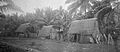
Village of Caroline Islands immigrants near Agana, 1899–1900.
-
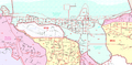
Census map of Hagåtña
.jpg)

See also
 In Spanish: Agaña para niños
