
Hale Creek facts for kids
Quick facts for kids Hale Creek |
|
|---|---|

Hale Creek in Los Altos, California.
|
|
| Country | United States |
| State | California |
| Region | Santa Clara County |
| Physical characteristics | |
| Main source | Foothills in Rancho San Antonio Open Space Preserve Los Altos Hills, California 950 ft (290 m) 37°20′46″N 122°08′08″W / 37.34611°N 122.13556°W |
| River mouth | Permanente Creek Mountain View, California 108 ft (33 m) 37°23′00″N 122°05′25″W / 37.38333°N 122.09028°W |
| Basin features | |
| Tributaries |
|
Hale Creek is a small stream that starts in the hills of Los Altos Hills, California, in Santa Clara County, California, United States. It begins in the Rancho San Antonio Open Space Preserve. The creek then flows about 4.6 miles (7.4 km) through the towns of Los Altos Hills, Los Altos, and Mountain View. Finally, it joins up with Permanente Creek.
Contents
History of Hale Creek

Hale Creek is named after Joseph P. Hale. He was a very large landowner in the western United States. He owned much of the land from the Rancho San Antonio area. Joseph Hale bought 2,000 acres of land from Juana Briones. He was one of the first big landowners in Los Altos.
In the 1930s, the Neary Rock Quarry was built on the upper part of Hale Creek. A quarry is a place where rocks are dug out of the ground. This quarry provided rocks for building Moffett Field. It also supplied crushed rock for Highway 101 and I280.
In 2006, the town of Los Altos Hills allowed a new neighborhood to be built. It was called Quarry Hills. This neighborhood included 22 fancy homes and a lake. The lake was made by building a dam where water flowed from the quarry into Hale Creek.
The Juan Prado Mesa Preserve is a special natural area in Los Altos Hills. It is located along Hale Creek, below the Neary Quarry. This preserve was created in 1970. It was named after Juan Prado Mesa, who was the first person to own the Rancho San Antonio land. A path called the Mary Stutz Path follows the creek through the preserve. You can enter this path from Stonebrook Road or Dawson Drive.
Hale Creek's Path and Water System


Hale Creek collects water from an area of about 5 square miles (13 square kilometers). It has three smaller streams that flow into it. These smaller streams are called tributaries. The creek starts at about 950 feet (290 meters) above sea level. This is just north of the Chamise Trail in the Rancho San Antonio Open Space Preserve. The water flows east into the north side of Neary Quarry.
The tributaries of Hale Creek are:
- Magdalena Creek (on the right side)
- Summerville Creek (on the left side)
- Loyola Creek (on the right side)
All these streams join Hale Creek before it reaches Interstate 280. Hale Creek ends when it meets Permanente Creek in Mountain View. This meeting point is near St. Joseph School and McKelvey Park.
The Santa Clara Valley Water District (SCVWD) has a plan for Hale and Permanente Creeks. It is called the Permanente Creek Flood Protection Project. This project aims to build special basins along the creeks. These basins will help catch floodwaters during heavy rains. This will protect homes, businesses, and schools downstream from flooding. The project also looks for ways to improve the environment around the creeks. This includes restoring the streams and creating new trails and open spaces.
Some parts of Hale Creek have been changed to a straight concrete channel. This helps move storm water faster. For example, at Marilyn Drive, the channel was built in 1952. At Arboleda Drive, it was built in 1960. In 2012, the SCVWD suggested making this concrete channel wider or deeper.
Animals and Plants of Hale Creek

Scientists studied the fish in Hale Creek in 1981. They did not find any Steelhead Trout (Oncorhynchus mykiss). However, Permanente Creek, which Hale Creek flows into, is known to have had trout. This suggests that steelhead trout might have used Hale Creek in the past.
Images for kids
-
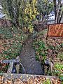
Hale Creek at Covington Road, Los Altos, after a rain in December 2021

