
Permanente Creek facts for kids
Quick facts for kids Permanente Creek |
|
|---|---|

California mule deer (Odocoileus hemionus) buck straddling perennial reach of Permanente Creek between Foothill Expressway and Interstate 280. Photo taken October 8, 2016.
|
|
| Other name(s) | Arroyo Permanente |
| Country | United States |
| State | California |
| Region | Santa Clara County |
| Cities | Los Altos, Mountain View |
| Physical characteristics | |
| Main source | Black Mountain in the Santa Cruz Mountains Los Altos 2,421 ft (738 m) 37°19′20″N 122°08′41″W / 37.32222°N 122.14472°W |
| River mouth | Mountain View Slough in southwest San Francisco Bay Mountain View 0 ft (0 m) 37°26′00″N 122°05′09″W / 37.43333°N 122.08583°W |
| Basin features | |
| Tributaries |
|
Permanente Creek is a stream about 13.3 miles (21.4 km) long in Santa Clara County, California. It starts on Black Mountain and flows north through Los Altos and Mountain View. The creek eventually reaches the southwest part of San Francisco Bay.
Early Spanish explorers called it Arroyo Permanente or Rio Permanente. This means "Permanent Creek" or "Permanent River" because it always had water flowing in it. The famous Kaiser Permanente health organization is named after this creek.
Contents
History of Permanente Creek
Early Inhabitants and Spanish Explorers
For over 3,000 years, the Ohlone people lived near Permanente Creek. They had a large village called Partacsi in this area. In March 1776, an expedition led by Colonel Juan Bautista de Anza traveled through here. He was finding the first land route from Monterey to San Francisco Bay.
Later that year, Mission Santa Clara de Asis was founded. Many local Ohlone people were brought to live there.
Ranchos and Land Ownership
In 1839, Governor Alvarado gave Rancho San Antonio de Padua to Juan Prado Mesa. This rancho was a large piece of land, about 440 acres (1.8 km2). It was located between Adobe Creek to the north and Stevens Creek to the south. Permanente Creek flowed through this rancho. On an old map from 1839, Permanente Creek is shown as Arroyo Permanente. Juan Prado Mesa was a soldier who had served at the Presidio of San Francisco and was known for his bravery. He passed away in 1845.
How Kaiser Permanente Got Its Name
Permanente Creek is also famous for being the namesake of Kaiser Permanente. This is a large health care company. Bess Kaiser and her husband, Henry J. Kaiser, had a lodge near the creek's source. This was above the big Permanente Quarry and Cement Plant. In 1945, Bess thought the creek's name, which means "permanent" and "dependable," would be perfect for their medical program. This program, which started in shipyards, later grew into Kaiser Permanente.
Permanente Creek Watershed
A watershed is an area of land where all the water drains into a single stream, river, or lake. The Permanente Creek watershed covers about 17.5 square miles (45 km2). The creek itself is about 13.3 miles (21.4 km) long.
Creek's Journey
Permanente Creek starts high up at 2,421 feet (738 m) on Black Mountain. This area is protected by the Midpeninsula Regional Open Space District. The creek flows down past the Permanente Quarry, which is now called the Lehigh Southwest Cement Plant and Quarry. For about five miles (8 km), it flows through undeveloped land. Then, it turns north and flows for another eight miles (13 km) across the valley floor.
Main Tributaries
Permanente Creek has two main streams that flow into it, called tributaries. They are the West Fork Permanente Creek and Hale Creek. The West Fork Permanente Creek and its Wildcat Canyon branch used to be known as Ohlone Creek.
The West Fork Permanente Creek starts on the east side of Ewing Hill. It flows east and forms High Meadow Pond. Below this pond, it joins Wildcat Canyon Creek. The West Fork then flows for about 3.2 miles (5.1 km) before joining the main Permanente Creek. This meeting point is about 0.5 miles (0.80 km) south of Interstate 280.
Water Flow in the Creek
The upper parts of Permanente Creek always have water flowing, which is called perennial flow. However, the parts of the creek on the valley floor often dry up, meaning their flow is ephemeral. There are two exceptions: the section of Permanente Creek between Foothill Expressway and Interstate 280, and the Hale Creek tributary, both have perennial flow.
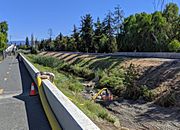
Permanente Creek Diversion Channel

Most of the upper Permanente Creek flows naturally for about 8 miles (13 km). However, when it reaches Portland and Miramonte Avenues, the creek enters a concrete channel. This channel was built by the Santa Clara Valley Water District (SCVWD).
This part of the creek becomes the Permanente Creek Diversion Channel. It was built in 1959 and runs for about 1.3 miles (2.1 km) to the east. It goes under Highway 85 and connects to Stevens Creek.
A special floodgate is closed every winter. This gate sends most of the winter water into Stevens Creek. This helps prevent floods in neighborhoods that are along the original creek path. Only during very big floods can some water go back into the original channel. This diversion means Permanente Creek now mostly ends at Stevens Creek, making it about 9.3 miles (15.0 km) long instead of 13.3 miles (21.4 km) to the Bay.
This connection to Stevens Creek is important for fish like steelhead trout. Even though steep drops in the diversion channel block fish from swimming upstream, changes could allow trout to reach the upper parts of Permanente Creek.
Lower Permanente Creek

The original creek channel, which now has much less water, flows north for another 1.5 miles (2.4 km). It meets Hale Creek near McKelvey Park. Then, Permanente Creek's original channel goes under U. S. Highway 101. It flows along the west side of the Google campus and out to the Bay at the Mountain View Slough. This area is just east of Shoreline Park.
Historically, this lowest part of the creek used to disappear into marshland before reaching the Bay. Its channel was extended to the Bay in the 1800s. The creek must have connected to the Bay during high winter flows. This allowed fish like steelhead to swim into Permanente Creek.
The Santa Clara Valley Water District has plans to dig deep basins to hold floodwaters. These basins would protect homes from big floods. One basin at McKelvey Park was finished in 2020. Another is planned for Rancho San Antonio Park.
Ecology of Permanente Creek
Animals in the Creek and Watershed
Permanente Creek is home to many animals. The California red-legged frog (Rana draytonii) is a federally threatened animal that lives in the upper parts of the creek. The US Fish and Wildlife Service wants to make sure there is enough habitat for these frogs to survive.
Other special wildlife species found near the quarry include:
- Dusky-footed woodrat (Neotoma fuscipes)
- White-tailed kite (Elanus leucurus)
- Olive-sided flycatcher (Contopus cooperi)
- Yellow warbler (Setophaga petechia)
- Grasshopper sparrow (Ammodramus savannarum)
Fish Life and Reproduction

Steelhead trout (a type of rainbow trout) used to live in Permanente Creek. While they can't swim up the creek anymore because of the diversion channel, some rainbow trout still live and reproduce there. Studies show that these trout are genetically unique. Removing barriers that block fish movement would help these trout thrive and increase their genetic diversity.
Other fish found in Permanente Creek include:
- Native fish: California roach (Lavinia symmetricus), Sacramento sucker (Catostomus occidentalis occidentalis), and threespine stickleback (Gasterosteus aculeatus).
- Non-native fish: Bluegill (Lepomis macrochirus), common carp (Cyprinus carpio), rainwater killifish (Lucania parva), and western mosquitofish (Gambusia affinis).
Trees Along the Creek

Many types of trees grow along Permanente Creek. One special tree is the State's tallest and third largest California bay laurel (Umbellularia californica). It is estimated to be over 200 years old!
Other trees found along the creek include:
- Willow ssp. (Salix ssp.)
- California sycamore (Platanus racemosa)
- white alder (Alnus rhombifolia)
- black cottonwood (Populus trichocarpa)
- Fremont cottonwood (Populus fremontii)
- bigleaf maple (Acer macrophyllum)
- California buckeye (Aesculus californica)
- California walnut (Juglans californica)
Burrowing Owls
The meadows in Shoreline Park, near where Permanente Creek meets the Bay, are important for the western burrowing owl (Athene cunicularia). These owls are a special concern in California because their numbers are decreasing in the Bay Area. In 2011, only three breeding pairs of owls raised ten young at Shoreline.
In 2003, the Stevens & Permanente Creeks Watershed Council was formed. This group helps protect and care for the creek areas.
Pollution in Permanente Creek
Mercury Pollution
The cement plant at the Permanente Quarry is a source of air pollution. It is responsible for a significant amount of mercury released into the air in the Bay Area. Mercury is a neurotoxin, which means it can harm the brain and nervous system. It can also build up in the food chain in water. Studies have shown higher levels of mercury in rain near the cement plant.
Selenium Discharges
Water from the quarry is pumped into Permanente Creek. This water can contain selenium, which is another pollutant. Selenium levels in the creek downstream from the quarry have been found to be much higher than safety standards. Selenium can bioaccumulate, meaning it builds up in the bodies of animals in the aquatic food web. This can be harmful to wildlife.
Sediment Discharges
Activities at the quarry and cement plant have caused a lot of sediment (like dirt and small rocks) to flow into Permanente Creek. The amount of sediment is much higher than what would naturally occur. This extra sediment can harm the rainbow trout that live in the creek.
Recreation Along Permanente Creek

Many parts of Permanente Creek are great for outdoor activities.
- Rancho San Antonio Park: A large section of the creek and its West Fork tributary are protected within Rancho San Antonio County Park and Rancho San Antonio Open Space Preserve. This area has over 23 miles (37 km) of hiking trails. You can walk about a mile from the main parking lot to visit the historic Deer Valley Farm on the West Fork Permanente Creek.
- Permanente Creek Trail: There is a trail that runs along the creek. It starts at the historic Rengstorff House in Shoreline Park and connects to the San Francisco Bay Trail. The Permanente Creek Trail goes south from there to West Middlefield Road.
Gallery
-
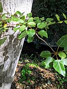
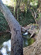
Native mature black cottonwood (Populus trichocarpa) in Permanente Creek between Foothill Expressway and Interstate 280. Note perennial flow October 8, 2016.
-
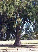
Giant California bay laurel by the creek in Rancho San Antonio County Park.
-
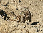
Family of burrowing owls.
-
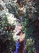
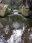
Perennial sections on the West Fork Permanente Creek persist through autumn in medium rainfall years, seen here in September 2011.
-
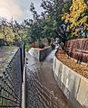
A weir on Permanente Creek in Los Altos roughly midway between Fremont Ave and Heritage Oaks Park.
-
Looking upstream at 1935 weir in Permanente Creek in Heritage Oaks Park.
-
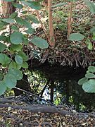
Mature (see dark exposed roots) native white alder (Alnus rhombifolia) in perennial section of Permanente Creek, October 8, 2016.
-
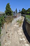
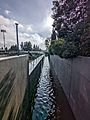
Below Fremont Avenue
-
Permanente Creek Diversion Channel behind Blach Middle School in Los Altos
-
In July, 2019, the entire flow of the creek is diverted through a hose for creekbed weed cleanout by the Google campus.
-
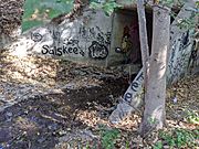
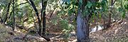
Permanente Creek as it exits Rancho San Antonio, flowing through the culvert beneath I-280, on the border of Los Altos.


Images for kids
-
The confluence of Hale Creek (right) and the reduced Permanente Creek (left) in Los Altos, viewed from Mountain View
-
Permanente Creek where it can overflow (to the left) into the McKelvey Park retention basin.


