
Adobe Creek (Santa Clara County) facts for kids
Quick facts for kids Adobe Creek |
|
|---|---|

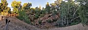
Fallen redwood in Adobe Creek. This large woody debris prevents erosion by slowing high flows and provides shelter for trout and other species
|
|

Location of the mouth of Adobe Creek in Palo Alto, California
|
|
| Other name(s) | Arroyo San Antonio (San Antonio Creek), Arroyo de las Yeguas (Yeguas Creek) |
| Country | United States |
| State | California |
| Region | Santa Clara County |
| Municipality | Los Altos Hills, Los Altos & Palo Alto, California |
| Physical characteristics | |
| Main source | Black Mountain in the Santa Cruz Mountains Los Altos Hills, California 2,600 ft (790 m) 37°19′12″N 122°09′19″W / 37.32000°N 122.15528°W |
| River mouth | Palo Alto Flood Basin in southwest San Francisco Bay Palo Alto, California 0 ft (0 m) 37°27′10″N 122°05′29″W / 37.45278°N 122.09139°W |
| Basin features | |
| Tributaries |
|
Adobe Creek is a stream about 14.2-mile-long (22.9 km) that flows north. It starts on Black Mountain in Santa Clara County, California, in the United States. The creek flows through the cities of Los Altos Hills, Los Altos, and Palo Alto. Long ago, Adobe Creek flowed all year round and was home to steelhead trout that swam up from the southwestern San Francisco Bay.


Contents
History of Adobe Creek
Early Inhabitants and Names
The Ohlone people were the first to live along Adobe Creek. A large mound of shells, which was once a village, was found near Adobe Creek in Palo Alto. In 1971, evidence of a smaller Ohlone settlement was found in Los Altos. This included a burial ground with skeletons and ceremonial beads, discovered during new construction near Adobe Creek. An old Ohlone basket was also found buried in the creek bank further north. Today, a historical marker stands at the O'Keefe site.
On an 1862 map, the upper part of the creek was called Arroyo San Antonio (San Antonio Creek). The lower part was called Arroyo de las Yeguas (Yeguas Creek). Yeguas means "mare" in Spanish. Mission Santa Clara named it this because they built a corral for mares along the creek's banks near the Bay. Later, Juan Prado Mesa renamed it San Antonio Creek when he received land in 1839. The name Adobe Creek first appeared on an official map in 1855, showing both the Adobe and San Antonio names for the creek.
Land and Settlements
In the 1830s, after the missions were closed, much of their land was given to important Californios (people of Spanish or Mexican descent living in California). Juan Prado Mesa, a soldier, built a large adobe house on his land. This house remained as a ruin for many years. Today, its site is on a hill near El Monte Avenue in Los Altos, California.
The upper part of Adobe Creek starts in the historic Rancho La Purísima Concepción. This land was given to Jose Gorgonio, an Indian from Mission Santa Clara, in 1840. He lived near Adobe Creek in Los Altos Hills. Much of the town of Los Altos Hills, California is on this old ranch land. In 1844, the ranch was sold to Juana Briones de Miranda. Her unique house, made of wood and adobe bricks, is at 4155 Old Adobe Road. It is a California State Historical Landmark. The house was damaged by the 1989 Loma Prieta Earthquake in 1989 but still stands today.
After 1831, Mexican ranch owners often built their homes near creeks. Adobe Creek was also used as a boundary between ranches. When Americans took over in 1850, much of this land was bought by people hoping to make money. It became large ranches for cattle and crops. Later, people realized that orchards and vineyards could grow there, which used more water. As the population grew, the land was divided into smaller pieces. This led to more wells being dug along Adobe Creek, causing the water level underground to drop significantly by the 1920s and 1930s.
Special Places and Names
The Trust for Hidden Villa is a non-profit group founded in 1924 by Frank and Josephine Duveneck. They bought most of the land where Adobe Creek begins. Hidden Villa became a place for learning and social change. They started the first Hostel on the Pacific Coast (1937) and the first multiracial summer camp (1945) there.
The software company Adobe Systems was named after Adobe Creek. Its founders lived next to the creek in Los Altos, California.
Paul Shoup, who founded Los Altos, chose a special spot on Adobe Creek for his home. His house, the Paul Shoup House, is the first property in Los Altos to be listed on the National Register of Historic Places.
Adobe Creek's Path
_Redwood_Grove_2011-06-25.jpg)


Adobe Creek drains an area of about 11 square miles (28 km2). It starts at 2,600 feet (790 m) on the side of Black Mountain in Los Altos Hills, California. Adobe Creek used to flow all year, which is why steelhead trout (a type of rainbow trout) lived there. Young trout need fresh water to survive. Old records show that people complained when the creek dried up because water was taken for farms. A lawsuit in 1919 mentioned that the creek used to flow "from Hidden Villa high in the hills... to the Santa Clara Valley and on to the sea." This confirms that Adobe Creek once flowed year-round. Today, parts of the creek still flow all year, especially above Hidden Villa and between Foothill Expressway and Interstate 280.
Creek Branches and Changes
Adobe Creek has several smaller branches. First, the Middle Fork Adobe Creek and the West Fork Adobe Creek (also called Letcher Creek) join it. Then, the North Fork Adobe Creek (also known as Bunny Creek) joins near the Duveneck's main house at Hidden Villa. The upper part of Adobe Creek is protected by Hidden Villa and the Midpeninsula Regional Open Space District.
Below these branches, three seasonal creeks join Adobe Creek in Los Altos Hills. These are Moody Creek (also called Silver Creek), named after a farmer who lived along it; Purisima Creek (historically Purissima Creek); and Robleda Creek. After this, Adobe Creek leaves the hills and flows through Los Altos, Mountain View, and Palo Alto for about 11 miles (18 km).
From 2003 to 2009, a part of Adobe Creek (between Foothill Expressway and West Edith Avenue) was improved. This project helped prevent floods and also made the creek better for wildlife. They removed concrete banks and planted native trees and shrubs, like California redwoods.
Further downstream, a bike path runs along the creek, following the Hetch Hetchy Aqueduct.
Some parts of Adobe Creek have been changed over time. For example, a straight concrete channel was built between El Camino Real and U.S. Highway 101 to help with drainage. In 1956, a developer redirected Adobe Creek into a new straight channel to prevent flooding. An 8-foot pipe was also built in 1975 to prevent flooding near Foothill College.
Before going under Highway 101, Adobe Creek is joined by Barron Creek. Barron Creek was once called Dry Creek. It used to flow into Matadero Creek but was later redirected back to Adobe Creek. Barron Creek is about 5.8 miles (9.3 km) long and has been changed a lot to control floods.
After passing under Highway 101, Adobe Creek flows into the Palo Alto Flood Basin. This basin helps control floodwaters from Adobe, Matadero, and Barron Creeks. The Flood Basin is kept a few feet below sea level to hold extra water. Adobe Creek joins Matadero Creek at the north end of Mayfield Slough. This area has a gate that lets fresh water flow into San Francisco Bay and some salt water come in with high tides.
In the 1800s, the Baylands marshes ended closer to Palo Alto. Old maps show Adobe Creek having two exits to the Bay: one into the marsh and another into San Francisquito Creek before it reached San Francisco Bay.
Watercourse gallery


-
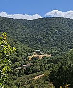
The headwaters above Hidden Villa, viewed from a hill above Moody Road in Los Altos Hills
-
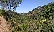
View from Rhus Ridge Trail, of the watershed of a branch, looking toward the main stem
-
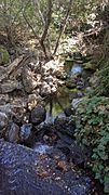
The creek takes a drop after it crosses under O'Keefe Lane, Los Altos.
-
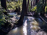
At high flow, a week after January 2017 rains, in Los Altos Redwood Grove
-
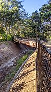
At the Los Altos–Palo Alto bike path along the Hetch Hetchy Aqueduct, with a fallen tree
-
At the Miller Avenue to Wilkie Way, Palo Alto, bicycle/pedestrian path
-
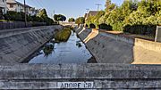
Looking north from East Meadow Drive, Palo Alto, in the dry season
-
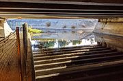
Under US Highway 101; during the dry season the underpass is used as a bicycle/pedestrian trail.


Wildlife and Plants


The creek flows through Redwood Grove, a 5.9-acre (24,000 m2) nature preserve in Los Altos. The city bought it in 1974. In 2009, efforts began to remove non-native plants and bring back native plants like redwoods and oaks. This helps create homes for wildlife. The coast redwoods (Sequoia sempervirens) were moved here from the Santa Cruz Mountains. You can also see native red willow (Salix laevigata) and arroyo willow trees. The historic Halsey House, built in the 1920s, is also in Redwood Grove. It used to hold a collection of Ohlone Indian artifacts found near the creek. In 2010, the city bought more land to connect Shoup Park and Redwood Grove with a safe path.
Native trees along the creek include willows (Salix species), California sycamore, White alder (Alnus rhombifolia), cottonwood, Bigleaf maple (Acer macrophyllum), California buckeye, California bay laurel, and California black walnut (Juglans californica).
Fish and Wildlife
Steelhead trout (a type of rainbow trout) used to live in Adobe Creek. An 1877 report mentioned trout in the creek, which means they were likely native and not introduced by humans. In 1893 and 1898, scientists collected steelhead trout from the creek. An old brochure from 1909 even promoted Los Altos for its "never-failing mountain trout stream." People who lived near the creek said that fish used to swim up to lay eggs. However, there are now many obstacles that make it hard for fish to travel up Adobe Creek. These include debris in fish ladders, drops above culverts, and long concrete channels.
Recently, four types of native fish have been found in Adobe Creek: California roach, Sacramento sucker, three-spined stickleback, and prickly sculpin. In 2007, other fish found in the lowest part of the creek included non-native common carp, rainwater killifish, and western mosquitofish. A 2011 survey found only native fish above El Camino Real, which is good news for the creek's health. However, further upstream, fewer fish are found because of barriers and less water due to diversions and wells.
Palo Alto Flood Basin

The Palo Alto Flood Basin was built in 1956 to prevent floods like the one in 1955. That year, a high tide stopped water from Matadero, Adobe, and Barron Creeks from flowing into San Francisco Bay. This caused severe flooding in Palo Alto. To control the water, a tidegate was placed where Adobe Creek, Matadero Creek, and the Bay meet. This gate keeps the flood basin about 2 feet below sea level, creating space for floodwaters. The tidegate has several small dams and one gate that can be opened to let tides in. This helps improve water quality and control mosquitoes.
Three groups manage the tidegates: Santa Clara Valley Water District, the City of Palo Alto, and Santa Clara County Vector Control. Because the gate and dams separate the basin from the Bay, large fish cannot easily swim between them unless the main gate is open. Also, the gates are set to keep the basin mostly fresh water. After a rainstorm, the tidegate is kept closed. This is exactly when steelhead trout would try to swim upstream. In 2002, a small opening was made in the gate for fish, but local fishermen haven't reported catching steelhead trout there in recent years.
In November 2002, about 100 striped bass, 5 bat rays, and 2 leopard sharks were found dead in the Flood Control Basin. This happened after the first big rainstorm washed a lot of leaves into the basin. This caused the water to have very low oxygen, which killed the fish.
Trails and Fun Activities
Adobe Creek Loop Trail
The San Francisco Bay Trail has a loop around the Palo Alto Flood Basin called the Adobe Creek Loop Trail. You can easily reach it from a parking lot at the end of San Antonio Road, just north of U.S. Highway 101. This trail is great for walking or mountain biking and offers amazing birdwatching. In winter, you can often see a large group of American white pelicans (Pelecanus erythrorhynchos).
The Adobe Creek Loop Trail starts by heading north along a raised path between Adobe Creek and Charleston Slough. Charleston Slough is a rich salt marsh with many shorebirds. At low tide, it looks like a salt pond, but it is connected to the tides. The trail then curves west, crossing over the tide gate of Mayfield Slough and entering the Palo Alto Baylands Nature Preserve. This preserve is a great place for birdwatching. The trail then heads back southwest, eventually connecting to the Bay Trail at East Bayshore Road.
Other Trails
Many people enjoy walking through Redwood Grove, where parts of the path are on a raised wooden boardwalk. In 1986, the city of Los Altos created a trail from Redwood Grove to the Manresa Lane Bridge.
Hidden Villa is the starting point for the Adobe Creek Trail, an easy two-mile hike upstream through a cool, wooded area. Two other trails connect Hidden Villa to the Black Mountain Trail at Ewing Hill. The Black Mountain Trail then continues up a challenging 3 miles (4.8 km) to the 2,800-foot (850 m) top of Black Mountain.
Another "Adobe Creek Trail" is in the Monte Bello Open Space Preserve. This is an easy to moderate 1.4-mile hike that starts on Montebello Road. It goes through the upper parts of the West Fork Adobe Creek and a large meadow with views of the South Bay.
