
Matadero Creek facts for kids
Quick facts for kids Matadero Creek |
|
|---|---|

Matadero Creek at Ross Road, Palo Alto
|
|
| Other name(s) | Arroyo del Matadero, Crosby's Creek, Madera Creek |
| Country | United States |
| State | California |
| Region | Santa Clara County |
| Physical characteristics | |
| Main source | Foothills of the Santa Cruz Mountains Los Altos Hills, California 640 ft (200 m) 37°22′01″N 122°09′04″W / 37.36694°N 122.15111°W |
| River mouth | Palo Alto Flood Basin, then Mayfield Slough, then southwest San Francisco Bay Palo Alto, California 0 ft (0 m) 37°25′27″N 122°08′01″W / 37.42417°N 122.13361°W |
| Basin features | |
| Tributaries |
|
Matadero Creek is a small stream that starts in the hills of the Santa Cruz Mountains in Santa Clara County, California. It flows about 8 miles (13 km) northeast. The creek eventually reaches the Palo Alto Flood Basin, where it joins Adobe Creek. From there, it flows into the San Francisco Bay. Matadero Creek runs through Los Altos Hills, Stanford University land, and Palo Alto.
Contents
A Look Back: The History of Matadero Creek


Matadero Creek has had a few different names over time. On old maps from the 1830s and 1840s, it was called Arroyo del Matadero. In Spanish, matadero means slaughtering place. This name likely came from a nearby cattle ranch.
Later, in 1862, a map by George F. Allardt called it Crosby's Creek. This was named after Elisha Crosby, who bought land nearby in 1853. By 1863, maps started calling it Matadero Creek again. In 1899, a map called it Madera Creek. Madera means timber or wood in Spanish, suggesting the area once had valuable trees.
In the late 1800s, important people bought land near the creek. In 1875, Peter Coutts bought over a thousand acres and called his property Ayrshire Farm. He built a tall brick tower near the creek, which probably marked the edge of his land. Later, in 1882, Leland Stanford, who founded Stanford University, bought Ayrshire Farm for his horse farm.
A famous writer named Wallace Stegner lived near Matadero Creek in Los Altos Hills. He was a professor at Stanford University. Stegner cared a lot about nature. In 1962, he helped start the Committee for Green Foothills. This group works to protect the hills, forests, creeks, and wetlands around the San Francisco Peninsula. Stegner's famous Wilderness Letter from 1960 helped create the Wilderness Act in 1964. This law protects wild areas in the United States. A pathway in Los Altos Hills is named the Stegner Pathway in his honor.
Where the Water Flows: Matadero Creek's Watershed


A watershed is an area of land where all the water drains into a single stream, river, or lake. Matadero Creek's watershed covers about 14 square miles (36 km2). Most of this area is hilly, with some flatter valley land.
Matadero Creek starts in Los Altos Hills. It has two main smaller streams, called tributaries, that flow into it:
- Arastradero Creek starts in Palo Alto and flows into Matadero Creek near Page Mill Road. Part of this creek is protected by the Arastradero Preserve.
- Deer Creek also starts in Los Altos Hills and joins Matadero Creek south of Foothill Expressway.
Another small stream, Santa Rita Creek, used to flow into marshlands. But it was later connected to Matadero Creek by a channel called the "Stanford Channel."
Near the lower parts of Matadero Creek, especially from Highway 101 to El Camino Real, the creek has been changed a lot. It flows through a wide concrete channel. This was done to help prevent floods.
Sometimes, during very heavy rains, water from Barron Creek can be sent into Matadero Creek through a special channel. This helps manage floodwaters in the area.
In 2012, the creek's water level suddenly dropped in some parts. This might have been related to the removal of polluted groundwater. Even so, the creek still flows all year long in Bol Park.
Amazing Animals: Ecology of Matadero Creek

_Matadero_Creek_Bill_Leikam_06-20-2011.jpg)

Matadero Creek is home to many interesting animals. Recently, gray foxes have been seen near where the creek meets the bay. Gray foxes are special because they are the only type of fox in North America that can climb trees! Their numbers have grown because efforts have been made to control non-native red foxes, which prey on endangered birds like the California clapper rail.
Historically, steelhead trout lived in Matadero Creek. These fish are a type of rainbow trout that migrate from the ocean to freshwater to lay their eggs. People reported seeing steelhead in the creek as recently as the late 1980s. In 1905, a scientist named John Otterbein Snyder found steelhead in what was then called "Madera Creek." Even though the creek sometimes didn't connect directly to the bay in the past, very high water levels during floods likely allowed the steelhead to reach it. Today, Matadero Creek is connected to the Palo Alto Flood Basin, which links to the bay.
In 1980, a harmful substance was accidentally dumped into the creek. This caused a big problem for the local Pacific tree frogs. Before this, the sound of tree frogs along the creek was very loud during warmer months. After the spill, most of them disappeared. Even with efforts to bring them back from other creeks, their numbers are still much lower than they used to be.
A group called Acterra helps monitor the health of the creek by studying the insects that live there. Insects can act as "indicator species," meaning their presence or absence can tell us how clean and healthy the stream is.
Controlling Floods: The Palo Alto Flood Basin

The Palo Alto Flood Basin was built in 1956 to stop floods. Before it was built, heavy rains in 1955 caused Matadero, Adobe, and Barron Creeks to overflow. This happened because a high tide in the San Francisco Bay stopped the water from flowing out of the creeks.
To prevent this, a special gate was built where Matadero and Adobe Creeks meet the San Francisco Bay. This gate helps control the water level in the flood basin. The basin is usually kept about 2 feet below sea level. This creates space to hold extra water during heavy rains, preventing floods upstream.
The gate has several small dams (weirs) and a larger gate that can be opened and closed. This allows some tidal water from the bay to enter the basin. This helps keep the water clean and controls mosquitoes. Three different groups work together to manage these gates: the Santa Clara Valley Water District, the City of Palo Alto, and Santa Clara County Vector Control.
Because of the gates, large fish from the bay cannot easily swim into the basin unless the main gate is open. Also, the gates are set to keep the basin mostly freshwater, not salty like the bay. After a rainstorm, the gate is kept closed. This can be a problem for steelhead trout, as they need to swim upstream during this time to lay their eggs.
In 2002, many fish, including about 100 striped bass, 5 bat rays, and 2 leopard sharks, died in the flood basin. This happened after the first big rainstorm of the season. It's thought that a lot of leaves and other plant material washed into the basin. This caused the water to lose oxygen, which fish need to breathe. The fish that died were all large, meaning they needed more oxygen, which supports this idea.
Images for kids
-
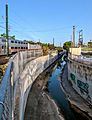
After crossing to the north of Lambert Ave in Palo Alto, Matadero Creek makes a turn to the southeast along the Caltrain tracks before crossing under them.
-
Matadero Creek at Hillview Avenue, Palo Alto, with Great Blue Heron


