
Black Mountain (near Los Altos, California) facts for kids
Quick facts for kids Black Mountain |
|
|---|---|

View of the Santa Cruz Mountains from the summit of Black Mountain on a cloudy day
|
|
| Highest point | |
| Elevation | 2,812 ft (857 m) NAVD 88 |
| Geography | |
| Location | Santa Clara County, California United States |
| Parent range | Santa Cruz Mountains |
| Topo map | USGS Mindego Hill |
Black Mountain is a tall hill in the Santa Cruz Mountains in west Santa Clara County, California. It's located south of Los Altos and Los Altos Hills, and west of Cupertino. Even though it's inside the Palo Alto city limits, it's far from the busy parts of the city.
This mountain sits right on the edge of two nature areas: Rancho San Antonio Open Space Preserve and Monte Bello Open Space Preserve. The very top of the mountain is in Rancho San Antonio. Early Spanish explorers often named dark-looking hills "Loma Prieta," which means "dark hill." They also called the middle part of the Santa Cruz Mountains "Sierra Morena," meaning "brunette mountain range." There are actually over 100 mountains named "Black Mountain" in California!
Contents
Mountain History
After a lot of trees were cut down in the 1800s, Italian farmers and winemakers moved to the slopes of Montebello Ridge. Dairies in the Santa Cruz Mountains provided milk for San Francisco and the nearby Peninsula. There was a big dairy farm near what is now the Montebello Open Space Preserve. Cattle used to roam freely on Black Mountain.
Oseo Perrone, a doctor from Italy, bought a large ranch on Black Mountain in 1885. He and his nephew started making wine there in 1892. This winery is now known as Ridge Vineyards.
George Morell, who started the Palo Alto Times newspaper, bought the Black Mountain Ranch in 1940. He loved the wild nature of the area. Morell later gave his land to Stanford University.
In 1975, the Midpeninsula Regional Open Space District (MROSD) bought the Black Mountain Ranch lands from Stanford. At that time, about 100 people lived there in a community called "The Land." They built homes among the oak trees and canyons. They had a large building for meals, workshops, and a food store. The community members grew their own food and enjoyed artistic activities.
Three important creeks start on Black Mountain and flow towards San Francisco Bay. Each creek has an interesting story!
Creek Stories
Stevens Creek begins on the west side of Black Mountain. It flows south, then north to the Bay. Spanish explorer Juan Bautista de Anza camped by this creek in 1776. He called it Arroyo San José de Cupertino. Anza was the first to travel by land to San Francisco Bay. He saw the bay from a hill near Rancho San Antonio County Park. The creek was later renamed for Elijah Stephens, a blacksmith who settled there in 1848. Stephens was famous for leading the first wagon train to cross the Sierra Nevada mountains.
Adobe Creek flows down the north side of Black Mountain to the Bay. It was first called Yeguas Creek. The people who started Adobe Systems, a software company, lived near this creek in Los Altos. They named their company after it! The upper part of Adobe Creek is protected by Hidden Villa. This is a special place started in 1924 by Frank and Josephine Duveneck. They wanted it to be a place for learning and new ideas. Hidden Villa had the first hostel on the Pacific Coast and the first summer camp for kids of all backgrounds.
Permanente Creek flows down the east side of Black Mountain. Early Spanish explorers called it Río Permanente because it always had water. This creek also gave its name to Kaiser Permanente. Bess Kaiser and her husband, Henry Kaiser, had a lodge near the creek. In 1945, Bess thought the creek's name would be perfect for their medical program. That program grew into Kaiser Permanente.

Nature and Animals
Black Mountain gets about 40 inches of rain each year. This is much more than the Santa Clara Valley below it, which is in the mountain's rain shadow (meaning it gets less rain).
The mountain's dark name suggests it was once covered in forests. Today, it's mostly grasslands and oak trees. But there's still a Coast Douglas-fir forest in the Stevens Creek valley. In the 1800s, loggers used oxen to drag huge fir and oak trees down the "Skid Road Trail." "Skids" were logs covered in water to make it easier to slide the cut trees. After 1975, when the area became an open space, new Douglas-fir trees started growing across the mountain.
The grasslands on Monte Bello ridge have many colorful wildflowers. These include California poppy, checker mallow, and blue-eyed grass. Large animals like coyotes, bobcats, deer, badgers, and mountain lions live here. You can also see many birds of prey, such as red-tailed hawks and northern harriers. Owls like great horned owls and barn owls also live on the mountain.
Mountain Geology
The geology of Black Mountain is quite special. The San Andreas Fault runs along the base of Monte Bello Ridge. Black Mountain is the highest point on this ridge. West of the fault, the land is on the Pacific Plate. It has old granite rocks, like those in the Sierra Nevada mountains. East of the fault, the land is on the North American Plate. Here, the rocks are different, including sandstone and basalt.
Right at the top of Black Mountain, you can find Calera limestone rocks. These rocks are quite rare in the Bay Area. Tiny fossils in the limestone show that the mountain was once a seamount (an underwater mountain) in the tropical Pacific Ocean. It moved here over millions of years! Calera is Spanish for 'limekiln', which is where limestone was heated to make lime for building. The summit is also higher than the hills to its west. This means you can sometimes see the ocean on a clear day.
Small amounts of gold and mercury were once mined here. There's even a legend about a "lost mine" where a Native American found gold. But its location is now unknown.
Black Mountain Today

Black Mountain is a popular spot for people who love to hike and mountain bike. The easiest way to reach the top is from the Monte Bello parking area on Page Mill Road. This path is about 2.5 miles (4 km) long. You can also reach the summit from the Rancho San Antonio entrance in Los Altos Hills. This route is about 5 miles (8 km) long and is a challenging hike.
Montebello Road also goes most of the way to the summit. This road is open to cars, but it's not usually very busy. On the summit, there are two broadcasting stations. One is for Stanford University, and the other belongs to the Federal Aviation Administration.
You can also find several wineries along Montebello Road. These include Ridge Vineyards, Fellom Ranch Vineyards, and Picchetti Brothers Winery.
Images for kids
-
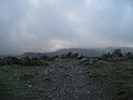
View of the Santa Cruz Mountains from the summit of Black Mountain on a cloudy day
-
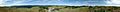
Panorama from the summit of Black Mountain
-
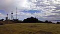
View from the highest point of the trail connecting Montebello Road and Page Mill Road.
