Haleakalā National Park facts for kids
Quick facts for kids Haleakalā National Park |
|
|---|---|
|
IUCN Category II (National Park)
|
|
 |
|
| Location | Maui County, Hawaii, United States |
| Nearest city | Pukalani |
| Area | 33,265 acres (134.62 km2) |
| Established | July 1, 1961 |
| Visitors | 1,087,616 (in 2022) |
| Governing body | National Park Service |
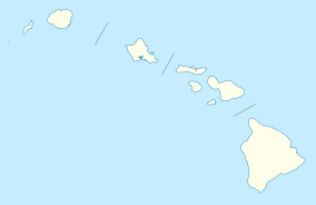
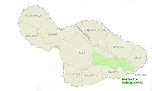
Haleakalā National Park is a special place in the United States. It is a national park located on the beautiful island of Maui, in Hawaii. The park gets its name from Haleakalā, a huge, sleeping volcano that is inside its borders. This amazing park covers about 33,265 acres (which is about 135 square kilometers). A large part of this area, about 24,719 acres, is a protected wilderness area. The land officially became a national park in 1976. Its boundaries were made even bigger in 2005 to protect more of its unique nature.
Discovering Haleakalā's Past
Haleakalā National Park has a rich history. It was first part of a larger park called Hawaii National Park, created in 1916. This bigger park also included the famous volcanoes of Mauna Loa and Kilauea on the island of Hawaiʻi. Later, in 1961, Hawaiʻi Volcanoes National Park became its own separate park. Haleakalā National Park was then established on its own.
In 1980, the park was recognized as an International Biosphere Reserve. This means it's a special place where people work to protect nature and learn about it. The name Haleakalā comes from the Hawaiian language. It means "house of the sun." An old Hawaiian story tells how the demigod Maui once captured the sun here. He did this to make the days longer for his people.
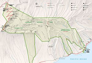
The park is home to the sleeping Haleakalā (East Maui) Volcano. This volcano last erupted a long time ago, between 1480 and 1600 AD. The park is split into two main parts. There's the high summit area and the beautiful coastal Kipahulu area.
Exploring the Haleakalā Summit
To reach the summit, you drive up a very winding but well-kept road. The summit area includes the amazing Haleakalā Crater. This is the very top of the volcano and the land around it. You can get to this part of the park using Hawaii State Road 378.
Near the top, there's a visitor center with parking and restrooms. At the highest point, there's another parking lot and a simple observatory.
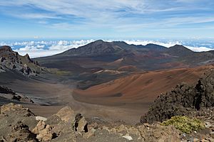
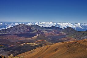
The most famous part of this area is the Haleakalā Crater. Even though it's called a crater, it was actually formed by erosion over time. It's huge, about 7 miles (11 kilometers) across and 2 miles (3 kilometers) wide. It's also very deep, about 2,600 feet (792 meters). Inside the crater, you'll see many volcanic features, like large cinder cones.
Two main trails let you hike into the crater from the summit. These are the Halemau'u and Sliding Sands trails. Both are known as National Recreation Trails. If you hike deep into the crater, you can even stay overnight in one of three cabins.
Many visitors love to come to the volcano's summit to watch the sunrise or sunset. The views are truly breathtaking!
Another interesting spot is Hosmer's Grove. This is a special forest with trees from all over the world. You can find deodar trees from the Himalayas, sugi from Japan, and eucalyptus from Australia. There are also pines, spruces, and firs from North America. Native Hawaiian plants grow here too, but they sometimes struggle. The taller, non-native trees can block their sunlight.
The park is famous for its volcanic landscapes and long, scenic drives. It also offers incredibly clear views of the night sky. Haleakalā is one of the best places in the United States for looking at stars. Many local shops rent binoculars and telescopes.
You might also spot Nēnē, which are Hawaiian geese, in their natural home inside Haleakalā Crater. These geese once disappeared from the park. But in 1946, they were brought back with help from the Boy Scouts. The Scouts carried young birds into the crater in their backpacks!
Haleakalā's Diverse Climates
The climate in Haleakalā National Park changes a lot depending on how high you are. Near the ocean, at the lowest parts, it feels like a tropical rainforest climate. This means it's warm and rainy. As you go higher up the mountain, the climate changes. It becomes more like an oceanic climate or even a Mediterranean climate. At the very top of Haleakalā, it's an alpine climate. This means it can be quite cold, like in the mountains.
Protecting Haleakalā's Environment
Haleakalā National Park faces some challenges in protecting its unique environment.
Impact of Feral Animals
Wild animals like deer, goats, and pigs that are not native to Hawaii can cause problems. They graze on plants and dig up the ground. This destroys native plants and causes the soil to wash away. This harms the variety of life in the park and can affect the water supply.
Saving Endangered Species
Keeping the Park Maintained
Keeping a national park in good shape requires a lot of work. As of 2018, the park needed about $24 million for repairs and upkeep. A big part of this was for unpaved roads. Other costs included trails, water systems, buildings, and campgrounds. To help with this, a group called the Haleakalā friends organizes monthly volunteer trips. They help clean cabins, remove harmful plants like thistles, and improve the habitat for the Nēnē geese.
Exploring the Coastal Kipahulu Area
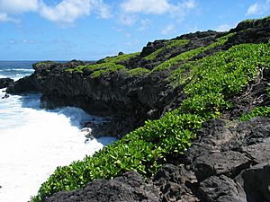
The second part of the park is the beautiful Kipahulu section. You can't drive directly here from the summit. Instead, you take a winding road along the coast. This area is in the lower part of Kipahulu Valley. The upper part of the valley separates it from the summit area. This upper valley is a special place called the Kipahulu Valley Biological Reserve. It's closed to visitors to protect the rare plants and animals that live in this delicate rainforest.
This coastal section is famous for its more than two dozen pools. These pools are along Palikea Stream in a gulch called ʻOheʻo. These pools are home to rare native freshwater fish. Visitors can swim in some of these pools. You can also hike a trail that leads to the base of the stunning Waimoku Falls.
Amazing Plants and Animals of Haleakalā
Haleakalā National Park is home to more endangered species than any other national park in the United States. When more people started visiting this island, some native species were harmed.
One example is the ʻāhinahina, also known as the Haleakalā silversword. This unique plant once covered Haleakalā Mountain so much that it looked like snow! Other endangered plants include the Haleakalā schiedea. Overall, more than 850 types of plants grow in the park. There are also four types of geraniums found only here.
The park is also home to tiny creatures called tardigrades, or "water bears." These amazing animals can survive in the extreme conditions near the mountain summit. In the 1980s, a biologist named Sam Gon III found 31 different tardigrade species here. He called Haleakalā "the richest place on Earth for tardigrades"!
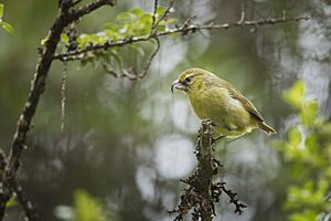
You can also find three types of Hawaiian Honeycreepers that live only on East Maui. These include the Maui Alauahio, the Akohekohe, and the Critically Endangered Kiwikiu. There are only about 200 Kiwikiu left, making them very rare.
Native invertebrates like insects, spiders, and snails also live in the park. The insects and spiders live in the rainforests and shrublands. Snails are mostly found in the park's rainforests, especially in the Kipahulu valley. Many of the park's rarest snails belong to the Partulina group. In Hawaiian, they are called Kāhuli.
Looking at the Stars from Haleakalā Observatory
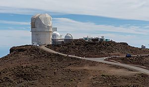
The Haleakalā Observatory is a special place for looking at space. It's located near the visitor center. This observatory is above the clouds, which means it has excellent viewing conditions and very clear skies. For over 40 years, the University of Hawaiʻi Institute for Astronomy has managed this site. They do important experiments about stars and space here.
One of its jobs is the Maui Space Surveillance System (MSSS). This system tracks satellites and space junk orbiting Earth. The observatory buildings are on a private road just past the summit. They are not actually inside the park's official boundary.
Images for kids
See also
 In Spanish: Parque nacional Haleakalā para niños
 | Emma Amos |
 | Edward Mitchell Bannister |
 | Larry D. Alexander |
 | Ernie Barnes |


