Hardwick (CDP), Vermont facts for kids
Quick facts for kids
Hardwick, Vermont
|
|
|---|---|

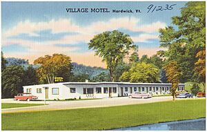
Village Motel of Hardwick, 1930-1945
|
|
| Country | United States |
| State | Vermont |
| County | Caledonia |
| Town | Hardwick |
| Area | |
| • Total | 1.59 sq mi (4.11 km2) |
| • Land | 1.57 sq mi (4.07 km2) |
| • Water | 0.02 sq mi (0.04 km2) |
| Elevation | 850 ft (260 m) |
| Population
(2020)
|
1,269 |
| Time zone | UTC-5 (Eastern (EST)) |
| • Summer (DST) | UTC-4 (EDT) |
| ZIP Code |
05843
|
| Area code(s) | 802 |
| FIPS code | 50-31750 |
| GNIS feature ID | 2586636 |
Hardwick is a small village in the state of Vermont, United States. It's located in Caledonia County. In 2020, about 1,269 people lived in the village part of Hardwick. The whole town of Hardwick had about 2,920 people.
Where is Hardwick?
Hardwick village is in the western part of Caledonia County, Vermont. It sits in the southern area of the larger town of Hardwick.
Roads and Rivers
Two main roads, Route 14 and Route 15, go through the village. They join up and follow Wolcott Street north from the center of Hardwick.
- Route 15 goes southeast for about 12 miles to U.S. Route 2 in West Danville. It also goes northwest for about 14 miles to Morrisville.
- Route 14 travels north for about 25 miles to Irasburg. It also goes south for about 19 miles to East Montpelier.
The Lamoille River flows right through the middle of Hardwick. This river then continues northwest until it reaches Lake Champlain, which is north of Colchester.
See also
- Hardwick (condado de Caledonia) para niños (in Spanish)

All content from Kiddle encyclopedia articles (including the article images and facts) can be freely used under Attribution-ShareAlike license, unless stated otherwise. Cite this article:
Hardwick (CDP), Vermont Facts for Kids. Kiddle Encyclopedia.


