Hazelwood, Minnesota facts for kids
Quick facts for kids
Hazelwood
|
|
|---|---|

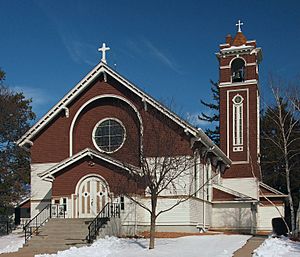
The Church of the Annunciation in Hazelwood
|
|
| Country | United States |
| State | Minnesota |
| County | Rice County |
| Township | Webster Township |
| Elevation | 1,047 ft (319 m) |
| Time zone | UTC-6 (Central (CST)) |
| • Summer (DST) | UTC-5 (CDT) |
| ZIP code |
55057
|
| Area code(s) | 952 |
| GNIS feature ID | 644811 |
Hazelwood is a small community in Minnesota, United States. It's called an unincorporated community because it doesn't have its own local government like a city or town. Instead, it's part of a larger area called Webster Township in Rice County.
Contents
Finding Hazelwood
You can find Hazelwood where two roads, Rice County Roads 3 and 46, meet. It's also close to a big highway called Interstate 35. Hazelwood is about 15 miles north of a city named Faribault.
Nearby Places
A small stream called Dutch Creek flows through the community. Other towns and cities nearby include Lonsdale, Elko New Market, and Northfield.
Postal Codes in the Area
The area around Hazelwood uses a couple of different ZIP codes. These are 55088, which is for Webster, and 55057, which is for Northfield. These two ZIP codes meet right near Hazelwood.
A Look Back: Hazelwood's Post Office
Hazelwood once had its very own post office. This post office was open for many years, from 1857 until 1905. It was run out of a general store owned by a man named John J. McCabe, who was also the postmaster.
 | Frances Mary Albrier |
 | Whitney Young |
 | Muhammad Ali |


