Heathwood, Queensland facts for kids
Quick facts for kids HeathwoodBrisbane, Queensland |
|||||||||||||||
|---|---|---|---|---|---|---|---|---|---|---|---|---|---|---|---|

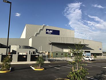
Asahi Beverages in the industrial estate, 2017
|
|||||||||||||||
| Population | 4,944 (2021 census) | ||||||||||||||
| • Density | 989/km2 (2,560/sq mi) | ||||||||||||||
| Established | 1975 | ||||||||||||||
| Postcode(s) | 4110 | ||||||||||||||
| Area | 5.0 km2 (1.9 sq mi) | ||||||||||||||
| Time zone | AEST (UTC+10:00) | ||||||||||||||
| Location | 29.9 km (19 mi) SW of Brisbane CBD | ||||||||||||||
| LGA(s) | City of Brisbane (Calamvale Ward) |
||||||||||||||
| State electorate(s) |
|
||||||||||||||
| Federal Division(s) | Oxley | ||||||||||||||
|
|||||||||||||||
Heathwood is a suburb located in the outer south-western part of Brisbane, Queensland, Australia. It's part of the City of Brisbane. In 2021, about 4,944 people lived there.
Contents
About Heathwood's Location
Heathwood is about 30 kilometers (18.6 miles) southwest of the main post office in Brisbane City. It's not a very big area. However, it is known for its many new and large houses.
How the Suburb is Divided
The Logan Motorway is a major road that runs through Heathwood. It splits the suburb into two main parts. The northern part is mostly for homes, where people live. The southern part is mainly for businesses and factories (industrial areas). Some parts of the south-eastern area are still undeveloped.
Heathwood's Boundaries
Heathwood has clear borders. To the north-east, it's bordered by Portree Crescent, Blunder Road, and Wadeville Street. To the south-west, it's next to Oxley Creek. Johnson Road forms the southern border, and Old Blunder Road is to the west.
Street Names in Heathwood
A cool fact about Heathwood is that all its streets are named after native Australian plants and trees.
Heathwood's History
Heathwood officially became its own suburb in 1970. Before that, it was part of Acacia Ridge. The suburb was named after an early settler who lived in the area a long time ago.
Who Lives in Heathwood?
The number of people living in Heathwood has grown quite a lot over the years.
- In 2011, there were 1,820 people living there. The average age was 32 years old.
- Most people (54.2%) were born in Australia. Other people came from countries like New Zealand, Vietnam, England, India, and South Africa.
- About 63.3% of people spoke only English at home. Other languages spoken included Vietnamese, Hindi, and Mandarin.
- By 2016, the population had increased to 2,794 people.
- In 2021, the population grew even more, reaching 4,944 people.
Schools Near Heathwood
There are no schools directly inside Heathwood itself.
- The closest primary school for younger students is Pallara State School. It's located in Pallara, right on the border with Heathwood.
- For older students, the nearest high school is Forest Lake State High School, which is in the nearby suburb of Forest Lake.
Getting Around Heathwood
Heathwood is well-connected to Brisbane CBD (the city center) and other areas.
Road Connections
You can reach Brisbane City using different roads like the Centenary Highway (through Forest Lake), the Ipswich Motorway (through Oxley), and the Logan Motorway.
Bus Services
Transport for Brisbane runs two bus routes that serve Heathwood:
- Route 118: This bus goes to Brisbane City. It travels through Forest Lake and along the Logan Motorway.
- Route 460: This bus also goes to Brisbane City. It stops at Forest Lake Shops, Richlands Station, and Indooroopilly along the way.
 | Aaron Henry |
 | T. R. M. Howard |
 | Jesse Jackson |


