
Heintzleman Ridge facts for kids
Quick facts for kids Heintzleman Ridge |
|
|---|---|

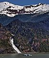
Heintzleman Ridge, south aspect
|
|
| Highest point | |
| Elevation | 3,940 ft (1,200 m) |
| Prominence | 690 ft (210 m) |
| Isolation | 2.76 mi (4.44 km) |
| Parent peak | Bullard Mountain |
| Geography | |

Heintzleman Ridge
Location in Alaska
|
|
| Location | Tongass National Forest Juneau Borough Alaska, United States |
| Parent range | Coast Mountains Boundary Ranges Juneau Icefield |
| Topo map | USGS Juneau B-2 |
| Climbing | |
| Easiest route | Hiking 3 mile trail |
Heintzleman Ridge is a mountain ridge in Alaska, United States. It stands about 3,940 feet (1,201 meters) tall. This ridge is about seven miles long. It stretches from Gastineau Channel to Nugget Mountain.
You can find Heintzleman Ridge about eight miles (13 km) north of Juneau. It is part of the Tongass National Forest. The Juneau International Airport is located near the ridge's southwest end. Even though it's not super high, the ridge rises sharply from sea level. It sits between Lemon Creek and Mendenhall Valley. The closest taller mountain is Bullard Mountain, about 2.75 miles (4.4 km) north.
Heintzleman Ridge is named after B. Frank Heintzleman (1888–1965). He was a forester who became the Governor of Alaska Territory from 1953 to 1957. He admired this ridge for its beauty. He once said he hoped "that ridge" would be named after him. The United States Board on Geographic Names officially adopted the name in 1966.
Climate and Weather
Heintzleman Ridge has a subarctic climate. This means it has cold, snowy winters. Summers are usually mild. Weather systems from the Gulf of Alaska hit the Coast Mountains. This causes a lot of rain and snow. Temperatures can drop very low, sometimes below -20 °C. The wind can make it feel even colder. This climate helps support the Juneau Icefield nearby. The best time to visit and hike the ridge is in July.
Images for kids
-
Heintzleman Ridge and Nugget Falls

