Hermantown, Minnesota facts for kids
Quick facts for kids
Hermantown
|
|
|---|---|
| Motto(s):
The City of Quality Living
|
|

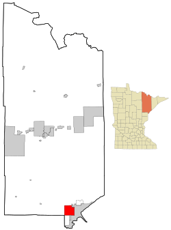
Location of the city of Hermantown
within Saint Louis County, Minnesota |
|
| Country | United States |
| State | Minnesota |
| County | Saint Louis |
| Incorporated | December 31, 1975 |
| Area | |
| • Total | 34.38 sq mi (89.05 km2) |
| • Land | 34.36 sq mi (89.00 km2) |
| • Water | 0.02 sq mi (0.06 km2) |
| Elevation | 1,365 ft (416 m) |
| Population
(2020)
|
|
| • Total | 10,221 |
| • Estimate
(2022)
|
10,126 |
| • Density | 297.45/sq mi (114.85/km2) |
| Time zone | UTC-6 (Central) |
| • Summer (DST) | UTC-5 (CDT) |
| ZIP codes |
55811, 55810
|
| Area code(s) | 218 |
| FIPS code | 27-28682 |
| GNIS feature ID | 0660490 |
Hermantown is a city in Saint Louis County, Minnesota, United States. In 2020, about 10,221 people lived here. It is a suburb of Duluth.
Hermantown has grown a lot. Many homes and businesses have been built here. This is why its population has increased. The city is located near the tip of Lake Superior.
The eastern part of Hermantown has many homes with large, green yards. It looks like a quiet neighborhood where people live and travel to work in a nearby city. The "Miller Hill area" of Duluth, which has many shops, has expanded into Hermantown. The western part of Hermantown is more like the countryside. It reminds people of the city's farming past. Hermantown's motto is "The City of Quality Living."
Wayne Boucher is the mayor of Hermantown. He won the election in 2008. He ran again in 2012 and was elected for a second term.
Contents
History of Hermantown
The first people to live in this area were Native Americans. They lived in the land "up over the hill" from Duluth.
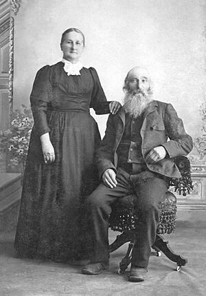
In 1867, two friends, August Kohlts and Lambert "Pat" Acker, claimed land here. They were both from Prussia, a country in Europe. Acker came to America when he was about five years old. Kohlts and his wife, Emilie, moved to America in 1860. Both families lived near Buffalo, New York, for some years.
Later, the Kohlts and Acker families traveled west. They went to Michigan to work in copper mines. Then, the Kohlts family moved to Minnesota. They were looking for free land under the Homestead Act. This law gave land to settlers who would farm it.
By 1870, the Kohlts family was living in Duluth. The Ackers arrived in Duluth in 1871. In 1872, August Kohlts started a farm outside Duluth. He and Acker were the first settlers in the area now called Hermantown. The area was named after a German leader known as Arminius or Herman.
Kohlts and Acker worked in Duluth and cleared their land. They traveled between Duluth and their farms on a Native American trail. This trail later became Piedmont Avenue and Hermantown Road.
The Jackson Project
Hermantown's population grew before World War II. This was because of a special government project. During the Great Depression, many people were poor. The government built "subsistence homestead" projects. These projects helped people move from cities to new homes in the countryside. Hermantown was chosen for one of these projects in Minnesota.
The Jackson Project was finished in 1937. It is a unique part of Hermantown's history. Many "Jackson Homes" can still be seen on some roads. These homes were built during the Depression. They were meant to help families grow their own food.
Each of the 84 homes had a brick farmhouse. Half of them also had a garage and barn. Each family received five or ten acres of land. They also got a pig, a cow, and 35 chickens. The idea was that families could raise their own food. They could sell extra food to pay off their debt to the government. The homes were sold at a low price, about $2,687.40.
The Jackson Project homes were built later than others. This meant they were better quality. All homes had plumbing and electricity. This project changed Hermantown. With 84 new homes, it started to become more suburban.
Hermantown officially became a city on December 31, 1975. The community of Adolph is located in Hermantown's southwest corner.
Geography and Location
Hermantown covers an area of about 34.37 square miles (89.05 square kilometers). Most of this area is land. Only a small part is water.
Main Roads and Waterways
Several important roads pass through Hermantown. These include U.S. Highway 53, State Highway 194 (MN 194), and County Road 13 (Midway Road). Other key roads are Maple Grove Road, Haines Road, and Arrowhead Road.
Many creeks and rivers flow through Hermantown. Miller Creek flows through the northeast. Keene Creek flows through the southeast. Kingsbury Creek enters the south-central part. Merritt Creek enters the southeast corner. Rocky Run flows through the northwest and west-central parts.
The Midway River starts in Hermantown. It flows southwest through the city. Then it goes into Midway Township. The Midway River eventually flows into the Saint Louis River.
Nearby Areas
Hermantown shares its borders with several other places. Seville Road runs along its northern border with Canosia Township. Solway Road runs along its western border with Solway Township. Saint Louis River Road runs along its southern border with Midway Township. Haines Road runs along its eastern border with Duluth.
Duluth International Airport is just northeast of Hermantown. The Pike Lake Business District is northwest of the city. The city of Proctor is directly south. The Bayview Heights, Piedmont Heights, and Duluth Heights neighborhoods of Duluth are all east or southeast of Hermantown.
Population Information
| Historical population | |||
|---|---|---|---|
| Census | Pop. | %± | |
| 1980 | 6,759 | — | |
| 1990 | 6,761 | 0.0% | |
| 2000 | 7,448 | 10.2% | |
| 2010 | 9,414 | 26.4% | |
| 2020 | 10,221 | 8.6% | |
| 2022 (est.) | 10,126 | 7.6% | |
| U.S. Decennial Census 2020 Census |
|||
2010 Census Details
In 2010, Hermantown had 9,414 people living in 3,355 households. A household is a group of people living in the same home. There were 2,351 families. The city had about 274 people per square mile.
Most of the people living in Hermantown were White (93.1%). Other groups included African American (2.4%), Native American (1.2%), and Asian (1.2%). About 2.2% of the population was Hispanic or Latino.
About 33.1% of households had children under 18. Most households (58.4%) were married couples. Some households had a female head (7.5%) or a male head (4.2%) without a spouse. About 29.9% were non-family households.
The average age in Hermantown was 40.1 years old. About 22.6% of residents were under 18. About 13.9% were 65 or older. The population was 54.0% male and 46.0% female.
Transportation
Public Transit
- Duluth Transit Authority provides bus services.
Major Highways
See also
 In Spanish: Hermantown (Minnesota) para niños
 | Emma Amos |
 | Edward Mitchell Bannister |
 | Larry D. Alexander |
 | Ernie Barnes |


