
Higuera facts for kids
Quick facts for kids
Higuera
Higuera de Albalat
|
|||
|---|---|---|---|
 |
|||
|
|||

Higuera
Location in Extremadura
|
|||
| Country | |||
| Community | |||
| Province | |||
| Comarca | Campo Arañuelo | ||
| Area | |||
| • Total | 40.54 km2 (15.65 sq mi) | ||
| Elevation | 480 m (1,570 ft) | ||
| Population
(2018)
|
|||
| • Total | 102 | ||
| • Density | 2.516/km2 (6.52/sq mi) | ||
| Demonym(s) | Higuereño/a | ||
| Postal code |
10359
|
||
.svg)
.svg)
Higuera, also known as Higuera de Albalat, is a small town in Spain. It is a municipality located in the Province of Cáceres. This province is part of Extremadura, which is one of Spain's autonomous communities. The town covers an area of about 40.54 square kilometers. In 2011, it had a population of 115 people.
Contents
Higuera's History
The name Higuera comes from an old Arab city called Makhada Albalat. This name means "way" or "road". An archaeological site with ruins of this ancient city is located next to Higuera.
Ancient Structures in Higuera
Among its historical sights, Higuera has the remains of an Islamic watchtower. It also has parts of its citadel, which was like a small fortress. These structures date back to the 10th or 11th centuries. You can find them on Castil Oreja mountain.
Geography of Higuera
Higuera is part of the judicial district of Navalmoral de la Mata. This means it's in an area served by a specific court. The town is located inside the beautiful Monfragüe National Park.
Rivers and Borders
The Tagus river, one of the longest rivers in the Iberian Peninsula, flows through the northern part of Higuera. The municipality shares its borders with several other towns. These include Almaraz, Campillo de Deleitosa, Casas de Miravete, Deleitosa, Romangordo, and Valdecañas de Tajo.
Distance to Other Cities
Higuera is not far from many important Spanish cities. It is about 55 kilometers from Trujillo and 79 kilometers from Plasencia. It's 82 kilometers from Guadalupe and 100 kilometers from Cáceres. The distance to Mérida is 141 kilometers, and to Madrid, the capital of Spain, it's 216 kilometers.
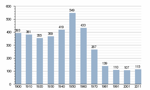
Higuera's Population Over Time
The study of how populations change is called demographics. The chart below shows how the number of people living in Higuera has changed over many years. You can see the population for different years, from 1900 to 2011.
See also
 In Spanish: Higuera de Albalat para niños
