
Hilda Peak facts for kids
Quick facts for kids Hilda Peak |
|
|---|---|

Hilda Peak (center) with Mount Athabasca (left)
|
|
| Highest point | |
| Elevation | 3,058 m (10,033 ft) |
| Prominence | 238 m (781 ft) |
| Parent peak | Mount Athabasca (3491 m) |
| Listing | Mountains of Alberta |
| Geography | |

Hilda Peak
Location in Alberta

Hilda Peak
Location in Canada
|
|
| Location | Alberta, Canada |
| Parent range | Canadian Rockies |
| Topo map | NTS 83C/03 |
| Climbing | |
| First ascent | 1938 E. Brooks, H. Brooks, R. Cross, W. Marples |
| Easiest route | Scramble |
Hilda Peak is a tall mountain in Canada, standing at 3,058 meters (about 10,033 feet) high. It's located in the northern part of Banff National Park in Alberta, which is a province in Canada. This mountain is part of the amazing Canadian Rockies mountain range.
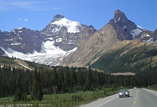
You can see Hilda Peak very clearly from the Icefields Parkway, a famous scenic road. It's near Sunwapta Pass. The mountain has two glaciers nearby: the Hilda Glacier to its south and the Boundary Glacier to its west. The closest taller mountain is Mount Athabasca, which is about 2 kilometers (1.2 miles) away.
Contents
Discovering Hilda Peak's History
The first people to climb Hilda Peak were E. Brooks, H. Brooks, R. Cross, and W. Marples. They reached the top in 1938. The mountain was given the name Hilda Peak in the same year.
The name "Hilda Peak" was officially accepted in 1985. This happened when the Geographical Names Board of Canada approved it.
How Hilda Peak Was Formed
Like other mountains in Banff National Park, Hilda Peak is made of sedimentary rock. This type of rock forms from layers of sand, mud, and tiny bits of sea creatures that settle over millions of years.
These rock layers were laid down during ancient times, from the Precambrian to the Jurassic periods. Imagine shallow seas covering this area long, long ago.
Later, during an event called the Laramide orogeny, huge forces pushed these rock layers. This caused them to fold and break, pushing older rock up and over younger rock. This process created the towering mountains we see today, like Hilda Peak.
Hilda Peak's Climate and Weather
Hilda Peak is located in a subarctic climate zone. This means it has very cold, snowy winters and mild summers. Temperatures can often drop below -20 °C (which is -4 °F). With the wind chill, it can feel even colder, sometimes below -30 °C (-22 °F).
The water from melting snow and ice on Hilda Peak flows east. It drains into Hilda Creek, then into Nigel Creek. These creeks are part of the North Saskatchewan River system.
Gallery
-
Hilda Peak (right) seen from the Icefields Parkway

