
Hinkhouse Peak facts for kids
Quick facts for kids Hinkhouse Peak |
|
|---|---|

North aspect (Okanogan County side)
|
|
| Highest point | |
| Elevation | 7,566 ft (2,306 m) |
| Prominence | 760 ft (232 m) |
| Isolation | 1.74 mi (2.80 km) |
| Parent peak | Early Winters Spires (7,807 ft) |
| Geography | |

Hinkhouse Peak
Location in Washington (state)

Hinkhouse Peak
Location in the United States
|
|
| Country | United States |
| State | Washington |
| County | Okanogan / Chelan |
| Parent range | Cascade Range North Cascades Okanogan Range |
| Protected area | Okanogan–Wenatchee National Forest |
| Climbing | |
| First ascent | Lage Wernstedt in 1925 or 1926 |
| Easiest route | Mountaineering |
Hinkhouse Peak is a mountain summit in Washington state. It stands tall at 7,566 feet (2,306 meters) above sea level. This peak is located right on the border between Okanogan County and Chelan County.
Hinkhouse Peak is part of the Okanogan Range. This range is a smaller part of the larger North Cascades mountain system. The peak is found within the Okanogan–Wenatchee National Forest. It's about 1.5 miles (2.4 km) north of Liberty Bell Mountain, which is a taller neighbor. Hinkhouse Peak is also near Washington Pass. It sits at the eastern end of a high ridge that connects to Cutthroat Peak. Another ridge goes northeast towards Constitution Crags.
Most of the water that runs off Hinkhouse Peak flows into Early Winters Creek. This creek then joins the Methow River. However, water from the south side of the peak drains into a stream that feeds the Chelan River. The mountain rises very steeply, climbing almost 3,200 feet (975 meters) from Early Winters Creek in just about one mile (1.6 km).
Contents
History of Hinkhouse Peak
This mountain is named in honor of Jimmy D. Hinkhouse. He was a mountaineer from Washington state. Jimmy Hinkhouse also worked as an economist for the Boeing Corporation in Seattle. He founded a group called One Step at a Time.
Sadly, Jimmy Hinkhouse passed away at age 52 while climbing Denali, a very tall mountain. The name "Hinkhouse Peak" was officially chosen in 2001. This decision was made by the United States Board on Geographic Names. Before 2001, the peak had other names. Some of these included State Crag, Towers of the Throat Gripper, Fickle Peak, and Washington Pass Peak.
Climate Around Hinkhouse Peak
Hinkhouse Peak is in a marine west coast climate zone. This means its weather is strongly influenced by the Pacific Ocean. Most weather systems start over the Pacific Ocean and move northeast. When these weather systems reach the North Cascades, the mountains force the air upward. This process is called orographic lift.
As the air rises, it cools down and drops its moisture. This causes a lot of rain or snow to fall on the Cascades. The western side of the North Cascades gets a lot of precipitation. This is especially true during the winter months, when heavy snowfall occurs. Because of the ocean's influence, the snow tends to be wet and heavy. This can create a high risk of avalanches. The North Cascades Highway, which is east of Washington Pass, is known for having many avalanche paths.
During the winter, the weather is often cloudy. But in the summer, high-pressure systems over the Pacific Ocean become stronger. This often leads to clear skies and sunny weather.
Geology of the North Cascades
The North Cascades mountains have very rugged and dramatic landscapes. You can see sharp peaks, long ridges, and deep valleys carved by glaciers. These unique features and big changes in elevation were created by geological events that happened millions of years ago. These events also led to the different climates found across the Cascade Range.
The formation of the Cascade Mountains began millions of years ago. This was during a time called the late Eocene Epoch. The North American Plate was slowly moving over the Pacific Plate. This movement caused many periods of volcanic activity. Also, small pieces of land, called terranes, came together. These pieces of oceanic and continental land formed the North Cascades about 50 million years ago. Hinkhouse Peak itself is mostly made from a type of granite. This granite comes from a large body of rock called the Golden Horn batholith.
About two million years ago, during the Pleistocene period, large sheets of ice called glaciers moved across the land. These glaciers advanced and then retreated many times. As they moved, they carved out the landscape. They left behind deposits of rock and debris. The U-shaped valleys you see today were formed by these recent glaciers. The combination of land being pushed up (orogeny) and cracks in the Earth's crust (faulting), along with glaciation, created the tall peaks and deep valleys of the North Cascades area.
Gallery
-
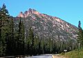
Hinkhouse Peak seen from Highway 20
-
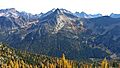
Hinkhouse Peak from PCT
-
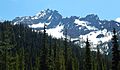
Hinkhouse Peak seen from the Cutthroat Lake Trailhead


See also
- Geography of Washington (state)
- Geology of the Pacific Northwest
