
Costa Mesa, California facts for kids
Quick facts for kids
Costa Mesa, California
|
|||
|---|---|---|---|

|
|||
|
|||
| Motto(s):
"City of the Arts"
|
|||

Location of Costa Mesa in Orange County, California
|
|||

Costa Mesa, California
Location in the Los Angeles metropolitan area

Costa Mesa, California
Location in California

Costa Mesa, California
Location in the United States
|
|||
| Country | United States | ||
| State | California | ||
| County | Orange | ||
| Incorporated | June 29, 1953 | ||
| Government | |||
| • Type | Council-manager | ||
| Area | |||
| • Total | 15.81 sq mi (40.96 km2) | ||
| • Land | 15.81 sq mi (40.94 km2) | ||
| • Water | 0.01 sq mi (0.02 km2) 0.29% | ||
| Elevation | 98 ft (30 m) | ||
| Population
(2020)
|
|||
| • Total | 111,918 | ||
| • Rank | 8th in Orange County 63rd in California |
||
| • Density | 7,080.73/sq mi (2,733.85/km2) | ||
| Demonym(s) | Costa Mesan | ||
| Time zone | UTC−8 (PST) | ||
| • Summer (DST) | UTC−7 (PDT) | ||
| ZIP Codes |
92626–92628
|
||
| Area code(s) | 714/657/949 | ||
| FIPS code | 06-16532 | ||
| GNIS feature IDs | 1652692, 2410239 | ||


Costa Mesa is a city in Orange County, California. Its name means "coastal tableland" in Spanish. This describes its location on a flat area near the coast.
Since it became a city in 1953, Costa Mesa has grown a lot. It started as a small farming town. Now, it's a busy urban area. It's known for its shops, businesses, and light manufacturing. The city is home to some of the tallest buildings in Orange County. In 2020, about 111,918 people lived there.
Contents
History of Costa Mesa

Long ago, the Tongva and Acjachemen Native American groups lived here. They had villages along the Santa Ana River thousands of years ago.
In 1769, Spanish explorers arrived. They named the area "Vallejo de Santa Ana," which means "Valley of Saint Anne." Later, in 1776, Mission San Juan Capistrano was built. This was the first permanent European settlement in the area.
In 1801, the Spanish Empire gave a large piece of land to Jose Antonio Yorba. He called it Rancho San Antonio.
After the Mexican-American War, California became part of the United States. American settlers moved in. In the 1880s, they started a town called Fairview.
Another community, Harper, grew up nearby. It was named after a local rancher. This town was successful because of its farms. On May 11, 1920, Harper changed its name to Costa Mesa. This new name, meaning "coastal tableland," describes the city's flat land near the ocean.
Costa Mesa's population grew quickly during and after World War II. Many soldiers trained at Santa Ana Army Air Base nearby. After the war, many of them returned with their families. The city's population grew five times larger in just 30 years.
Geography and Climate
Costa Mesa is about 37 miles (60 km) southeast of Los Angeles. It is also about 87 miles (140 km) northwest of San Diego. The city covers about 16 square miles (41 km2). Its southern border is only about 1 mile (1.6 km) from the Pacific Ocean.
Costa Mesa has a mild climate all year round. It's a semi-arid climate, which means it's usually dry. Most of the rain falls in the winter months. Summers are very dry with almost no rain.
Population and People
| Historical population | |||
|---|---|---|---|
| Census | Pop. | %± | |
| 1960 | 37,550 | — | |
| 1970 | 72,660 | 93.5% | |
| 1980 | 82,562 | 13.6% | |
| 1990 | 96,357 | 16.7% | |
| 2000 | 108,724 | 12.8% | |
| 2010 | 109,960 | 1.1% | |
| 2020 | 111,918 | 1.8% | |
| U.S. Decennial Census | |||
Costa Mesa has grown steadily over the years. In 1960, about 37,550 people lived here. By 2020, the population had grown to 111,918.
The city is a diverse place. Many different groups of people live here. In 2020, about 48% of the people were White. About 36% of the population was Hispanic or Latino. There are also significant numbers of Asian and Mixed race residents.
Economy and Jobs
Costa Mesa's economy mainly focuses on shopping and services. The biggest shopping area is South Coast Plaza. It's a huge shopping center with over 270 stores. It brings in more than $1 billion in sales each year. This makes it one of the busiest shopping centers in the country.
The area around South Coast Plaza is called South Coast Metro. It's a busy place with businesses, cultural spots, and homes.
Some companies also make things in Costa Mesa. These are often electronics, medicines, and plastics. Experian, a big business services company, has its North American headquarters here. It's the largest employer in the city.
Many well-known companies have their main offices in Costa Mesa. These include El Pollo Loco, Vans, and Volcom. The local newspaper, the Daily Pilot, is also published here.
Costa Mesa has 26 parks and a city golf course. It also has 26 public schools and two libraries.
Major Employers in Costa Mesa
Here are some of the biggest employers in the city:
| # | Employer | # of employees |
|---|---|---|
| 1 | EPL Intermediate, Inc. | 3,998 |
| 2 | Experian | 3,700 |
| 3 | Coast Community College District | 2,900 |
| 4 | Orange Coast College | 1,900 |
| 5 | Automobile Club of Southern California | 1,773 |
| 6 | Anduril Industries | 1,100 |
| 7 | Deloitte & Touche LLP | 700 |
| 8 | FileNet | 600 |
| 9 | Vans | 550 |
| 10 | Vanguard University | 319 |
Arts and Culture
Annual Events
The Orange County Fair happens every July in Costa Mesa. Over a million people visit the fair each year. It's a very popular event!
The Annual Scarecrow & Pumpkin Festival started in 1938. After a long break, it was brought back in 2013.
Arts Facilities

Next to the fairgrounds is the Pacific Amphitheatre. Many famous music artists have performed here.
The Segerstrom Center for the Arts and South Coast Repertory Theater are also in Costa Mesa. These places offer plays, concerts, and other cultural events.
Football Training
Costa Mesa has been home to the training camp for NFL teams. Since 2024, the Las Vegas Raiders have trained here. Before that, the Los Angeles Chargers used the facility from 2017 to 2024.
The training center is called the Jack Hammett Sports Complex. It used to be an office building. The teams changed it to have special rooms for players and coaches.
Education in Costa Mesa
Costa Mesa has several colleges. These include Orange Coast College and Vanguard University.
The city also has two public high schools: Costa Mesa High School and Estancia High School. There are two public middle schools: TeWinkle Middle School and Costa Mesa Middle School. TeWinkle Middle School is named after Costa Mesa's first mayor.
There are also alternative high schools like Back Bay High School and Monte Vista High School. These schools are part of the Newport-Mesa Unified School District.
Transportation
Most people in Costa Mesa travel by car. The city has several major highways. California State Route 55 (Costa Mesa Freeway) and California State Route 73 (Corona del Mar Freeway) both end in Costa Mesa. The San Diego Freeway (Interstate 405) also goes through the city.
The Orange County Transportation Authority (OCTA) provides bus services in Costa Mesa.

City Services
Civic Center
The Costa Mesa Civic Center is a large area where the city government works. The main city hall building has five floors. It's where most of the city's important tasks are done. The Civic Center also has the Police facility and Fire Station No. 5.
Emergency Services
The Costa Mesa Fire Department provides fire protection for the city. The Costa Mesa Police Department is in charge of law enforcement. Emergency medical services are handled by the Fire Department and Care Ambulance Service.
Sister City
Costa Mesa has a "sister city" relationship with:
- Wyndham, Australia
Images for kids
-
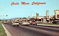
Newport Boulevard in the 1950s

See also
 In Spanish: Costa Mesa para niños
