
Horrenbach-Buchen facts for kids
Quick facts for kids
Horrenbach-Buchen
|
||
|---|---|---|
|
||

Horrenbach-Buchen
Location in Switzerland

Horrenbach-Buchen
Location in Canton of Bern
|
||
| Country | Switzerland | |
| Canton | Bern | |
| District | Thun | |
| Area | ||
| • Total | 20.4 km2 (7.9 sq mi) | |
| Elevation | 1,000 m (3,000 ft) | |
| Population
(Dec 2020 )
|
||
| • Total | 226 | |
| • Density | 11.08/km2 (28.69/sq mi) | |
| Postal code |
3623
|
|
| Surrounded by | Beatenberg, Eriz, Homberg, Oberlangenegg, Sigriswil, Teuffenthal, Unterlangenegg | |

Horrenbach-Buchen is a small community located in the beautiful Canton of Bern, Switzerland. It's a municipality within the Thun administrative district. This area is known for its stunning mountain views and quiet, rural life.
Contents
A Glimpse into Horrenbach-Buchen's Past
Long ago, the small farming villages that make up Horrenbach-Buchen were part of a territory called Herrschaft (which means "lordship" or "rule"). This area was controlled by a powerful family known as the House of Kyburg.
However, things changed in 1384. After a conflict called the Burgdorferkrieg, the Kyburg family lost most of their lands, including Horrenbach-Buchen, to the city of Bern. Under Bern's rule, Horrenbach-Buchen became part of the Steffisburg court, which was under the Thun District.
For a long time, the people of Horrenbach-Buchen went to church in Steffisburg. But in 1693, they joined the Schwarzenegg parish. Later, a church was built right in Buchen in 1928, and it became their own parish church in 1935.
In the past, most people here were farmers. They practiced seasonal alpine herding, meaning they moved their animals to different pastures depending on the season. Today, many residents travel to Thun for work, while others work in tourism, helping visitors enjoy the area.
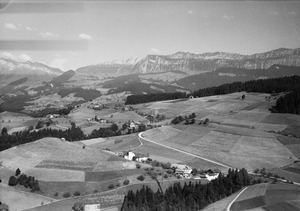
Exploring Horrenbach-Buchen's Geography
Horrenbach-Buchen covers an area of about 20.37 square kilometers (about 7.86 square miles). A large part of the land, about 50%, is used for farming. Forests cover another 39.4% of the area, making it a very green place.
Only a small part of the municipality, about 1.3%, has buildings or roads. About 1.2% is covered by rivers or lakes. The remaining 7.9% is unproductive land, meaning it's too rocky or has too much vegetation to be used for farming or building.
The municipality is nestled in the mountains, on the left side of the Zulg river valley. It's not one big town but rather a collection of scattered hamlets (small villages) and individual houses. A stream called the Teuffenbach divides the municipality into two main parts: Buchen in the west and Horrenbach in the east.
In 2010, the old district of Amtsbezirk Thun was dissolved. Horrenbach-Buchen then joined the new Verwaltungskreis Thun district.
Understanding the Coat of Arms
A coat of arms is like a special symbol or emblem for a town or family. The coat of arms for Horrenbach-Buchen has a red background. It features a silver stripe going across it diagonally, with three green beech leaves on the stripe. There are also two silver stars, one on each side of the stripe.
Who Lives in Horrenbach-Buchen?
Horrenbach-Buchen has a population of about 256 people (as of December 2012). A very small number, about 1.2%, are people from other countries living there. Most of the people (100% in 2000) speak German as their main language.
In 2008, the population was slightly more male (55.5%) than female (44.5%). Most residents were born either in Horrenbach-Buchen itself or elsewhere in the Canton of Bern.
When looking at age groups (as of 2012), children and teenagers (0–19 years old) make up about 21.5% of the population. Adults (20–64 years old) are the largest group at 61.7%, and seniors (over 64 years old) make up 16.8%.
How People Make a Living
In 2011, Horrenbach-Buchen had a very low unemployment rate of just 0.31%. This means almost everyone who wanted a job had one.
The economy of Horrenbach-Buchen is divided into three main parts:
- Primary Sector: This includes jobs directly related to natural resources, like farming. In 2011, 60 people worked in this sector, mostly in agriculture.
- Secondary Sector: This involves manufacturing and construction. There were 14 people working in this sector, with 4 businesses.
- Tertiary Sector: This covers services, like shops, hotels, restaurants, and healthcare. 19 people worked in this sector, with 6 businesses.
Many residents of Horrenbach-Buchen travel to other towns for work. In 2000, 62 people commuted out of the municipality for their jobs, while only 12 commuted in. This means more people leave Horrenbach-Buchen to work than come in. About 47.6% of workers used a private car to get to work.
The local and cantonal tax rates in Horrenbach-Buchen are quite low compared to other places in the canton. This means residents pay less in taxes.
Religious Life
According to the 2000 census, most people in Horrenbach-Buchen, about 90.5%, belonged to the Swiss Reformed Church. A smaller number, about 3.6%, were Roman Catholic. Some people belonged to other Christian churches, and a few did not belong to any church.
Learning and Education
Education is important in Horrenbach-Buchen. About 40.5% of the population has completed non-mandatory upper secondary education, which is like high school. A smaller group, 5.4%, has gone on to higher education, such as a university or a specialized college (a Fachhochschule).
In 2000, there were 26 students attending school within the municipality. Most of these students (25) also lived in Horrenbach-Buchen. At the same time, 11 residents went to schools outside the municipality.
See also
 In Spanish: Horrenbach-Buchen para niños
