
Sigriswil facts for kids
Quick facts for kids
Sigriswil
|
||
|---|---|---|

Sigriswil village
|
||
|
||

Sigriswil
Location in Switzerland

Sigriswil
Location in Canton of Bern
|
||
| Country | Switzerland | |
| Canton | Bern | |
| District | Thun | |
| Area | ||
| • Total | 55.41 km2 (21.39 sq mi) | |
| Elevation | 810 m (2,660 ft) | |
| Population
(Dec 2020 )
|
||
| • Total | 4,847 | |
| • Density | 87.475/km2 (226.56/sq mi) | |
| Postal code |
3655
|
|
| Localities | 11 villages (Aeschlen ob Gunten, Gunten, Meiersmaad, Merligen, Ringoldswil, Schwanden, Sigriswil, Tschingel ob Gunten, Wiler, Endorf, Reust); Justistal | |
| Surrounded by | Beatenberg, Heiligenschwendi, Horrenbach-Buchen, Krattigen, Leissigen, Oberhofen am Thunersee, Spiez, Teuffenthal | |
| Twin towns | Lutry (Switzerland), Villa General Belgrano (Argentina) | |

Sigriswil is a small town, also called a municipality, in Switzerland. It is located in the canton of Bern, near the city of Thun.
Contents
History of Sigriswil
Sigriswil was first written about in documents between 1222 and 1223. It was called Sigriswile back then.
Who lived in Sigriswil first?
Long, long ago, about 5,000 years ago, people lived in the Sigriswil area. This was during the Late Neolithic (New Stone Age) and Bronze Age. The first modern people to settle here were likely from the Alamanni tribes. They arrived around the 5th century A.D. and lived near Thun lake. Later, between the 8th and 10th centuries, they moved higher up into the mountains.
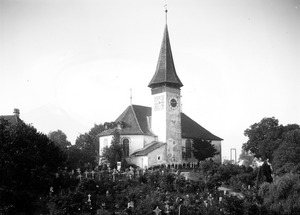
The Sigriswil Church
The village church, named after St. Gallus, was first mentioned in 1222-23. It was one of twelve churches around Lake Thun. However, it was probably built much earlier, between the 10th and 12th centuries. In the 13th century, the Interlaken Monastery gained special rights over the church and the nearby Justistal area.
How Sigriswil Gained Freedom
In 1347, the people of Sigriswil bought their freedom. They paid 300 "Thun Pennies" to Count Eberhard. He was a noble from the House of Kyburg who needed money. By 1384, the Bern government ruled the municipality. But the people of Sigriswil could still govern themselves.
Changes to the Church and Religion
In 1467, the old church was taken down, and a new one was built. In 1528, Bern adopted the Protestant Reformation. This meant all monasteries, including Interlaken Monastery, were closed. The rights over the church then went to Bern. The Justistal area also became part of the municipality. The church you see today was built in 1678-79, after the second one was taken down.
Sigriswil in Modern Times
After the French invaded Switzerland in 1798, Sigriswil became part of a new area called the Canton of Oberland. When that area ended in 1803, Sigriswil rejoined the Canton of Bern.
For a long time, people in Sigriswil fished in Lake Thun. They also grew crops and vineyards in the valley. In the summer, they raised cattle in the high mountain meadows. They would then bring the cattle down for winter. By 1914, the wine industry in Sigriswil ended. This was due to diseases, competition from imported wine, and the start of World War I.
In the late 1800s and early 1900s, steamboats and better roads brought tourists to Sigriswil. Hotels and restaurants opened near the lake and on the slopes. Today, Sigriswil is a peaceful farming village and a popular place for tourists to visit.
The famous US statistician George Gallup had a summer home in Tschingel ob Gunten, a village in Sigriswil. He passed away there in 1984.
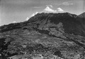
Geography of Sigriswil
_164.JPG)
Sigriswil covers an area of about 55.34 square kilometers. A large part of this land is used for farming (39.3%) or is covered by forests (47.1%). About 4.7% of the area has buildings or roads. Rivers and lakes make up 0.5%, and 8.3% is land that can't be used for farming or building.
What is the landscape like?
Sigriswil is located along the right side of Lake Thun. It includes the area where the Zulg river flows. It also has two mountain ranges: the Güggisgrat and the Sigriswilgrat.
Villages in Sigriswil
The municipality of Sigriswil is made up of eleven villages. These include Gunten, Merligen am See, Aeschlen, Sigriswil, Endorf, Ringoldswil, Tschingel, Schwanden, Meiersmaad, Reust, and Justistal. There are also smaller groups of houses called hamlets.
Coat of Arms
The coat of arms for Sigriswil shows a silver grape tub with golden hoops. It is filled with blue grapes and green leaves. This sits on three green hills.
Population and People
_132.JPG)
Sigriswil has a population of about 4,679 people (as of December 2012). About 10.1% of the people living here are from other countries.
Languages Spoken in Sigriswil
Most people in Sigriswil speak German as their main language (95.0%). A smaller number of people speak Portuguese (0.9%) or French (0.7%).
Where do people come from?
About 41.2% of the people living in Sigriswil in 2000 were born there. Another 31.6% were born in the same canton (Bern). About 13.5% were born elsewhere in Switzerland, and 9.8% were born outside of Switzerland.
Age Groups in Sigriswil
As of 2012, children and teenagers (0–19 years old) make up 15.9% of the population. Adults (20–64 years old) are 56.5%, and seniors (over 64 years old) are 27.6%.
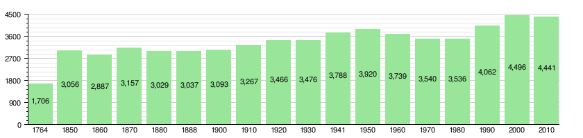
Population Changes Over Time
The chart below shows how the population of Sigriswil has changed throughout history:
Economy of Sigriswil

In 2011, Sigriswil had a low unemployment rate of 1.5%. Many people work in the municipality. There are 1,639 people employed here.
What kind of jobs are there?
Jobs in Sigriswil are divided into three main groups:
- Primary sector: This includes jobs that get raw materials from nature. In Sigriswil, this means agriculture (farming), forestry (working with trees), and fishing. There are 333 people working in this sector.
- Secondary sector: This involves making things. In Sigriswil, this includes manufacturing (making products) and construction (building things). There are 167 people working here.
- Tertiary sector: This involves providing services to people. This is the largest sector in Sigriswil, with 1,138 people working in areas like sales, transportation, hotels, restaurants, healthcare, and education.
Many people who live in Sigriswil also work there. In 2000, 1,018 workers both lived and worked in the municipality. Most people (54.2%) use a private car to get to work, while 14% use public transportation.
Taxes in Sigriswil
The tax rates in Sigriswil are among the lowest in the canton of Bern. This means people living and working here pay less in local and cantonal taxes compared to many other places.
Places to See
The entire hamlet of Wiler is a special place. It is recognized as an important part of Swiss heritage. You can also visit the Sternwarte Sirius observatory in Schwanden.
Religion in Sigriswil

According to the 2000 census, most people in Sigriswil (76.3%) belong to the Swiss Reformed Church. About 8.7% are Roman Catholic. A smaller number of people belong to other Christian churches. Some people are Muslim (1.13%). About 6.56% of the population do not belong to any church.
Education in Sigriswil
In Sigriswil, many adults have completed higher education. About 57.6% have finished non-mandatory high school, and 16.6% have gone on to university or a technical college.
School System
The school system in the Canton of Bern starts with one year of optional Kindergarten. After that, students attend six years of Primary school. Then, there are three years of mandatory lower Secondary school. Students are grouped based on their abilities. After secondary school, students can continue their education or start an apprenticeship (learning a trade on the job).
Schools in Sigriswil Today
During the 2012-13 school year, 360 students attended schools in Sigriswil. There are 7 active primary schools. The only secondary school is in Sigriswil village.
The municipality also has a public library called Gemeindebibliothek Sigriswil. In 2008, it had 5,522 books and other items. It loaned out over 16,000 items that year.
Images for kids
-
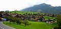
Houses in the mountains in Sigriswil
-
Aerial view of Sigriswil (1952)

See also
 In Spanish: Sigriswil para niños
