
Huaraz facts for kids
Quick facts for kids
Huaraz
San Sebastián de Huaraz
|
|||
|---|---|---|---|
|
City
|
|||
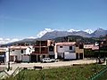
      Top: White mountain range, Second left: La Soledad neighborhood, Second right: Gamarra Avenue, Third left: Residential street in Huarupampa suburb, Third right: Building development, Bottom: Cultural Center and Municipal Theater
|
|||
|
|||
| Motto(s):
The noble and generous City, Capital of International Friendship, Natural Paradise of the World
|
|||

Huaraz
Location in Peru
|
|||
| Country | |||
| Region | Ancash | ||
| Province | Huaraz | ||
| Founded | 20 January 1574 | ||
| Government | |||
| • Type | Democracy | ||
| Area | |||
| • Total | 370.03 km2 (142.87 sq mi) | ||
| Elevation | 3,052 m (10,013 ft) | ||
| Population
(2017)
|
|||
| • Total | 118,836 | ||
| • Estimate
(2015)
|
127,041 | ||
| • Density | 321.152/km2 (831.781/sq mi) | ||
| Time zone | UTC-5 (PET) | ||
| • Summer (DST) | UTC-5 (PET) | ||
| Area code(s) | 43 | ||
| Website | www.munihuaraz.gob.pe | ||


Huaraz (pronounced wah-RAHS) is a vibrant city in Peru. Its name comes from the Quechua word Waraq, meaning "dawn." Huaraz is the capital of the Ancash Region and the main city of Huaraz Province.
The city sits in the middle of the beautiful Callejón de Huaylas valley, right next to the Santa River. It's about 3,050 meters (10,000 feet) above sea level. Huaraz is home to about 120,000 people, making it the second-largest city in the central Peruvian Andes.
Huaraz is a major hub for business, trade, and tourism in the Ancash region. It's especially famous for adventure sports and winter activities. People from all over the world come here to enjoy climbing, hiking, mountain biking, and snowboarding. They also visit the amazing glaciers and mountains of the Cordillera Blanca, including Huascarán, the tallest mountain in the tropics. These natural wonders are part of Huascarán National Park, which is a UNESCO World Heritage site.
The city has a long history, dating back to before the Inca Empire. It was officially founded by the Spanish in 1574. During Peru's fight for independence, Huaraz strongly supported the army, earning it the title "Noble and Generous City" from Simón Bolívar. In 1970, a powerful earthquake destroyed most of the city, and about 25,000 people lost their lives. Many countries helped Huaraz rebuild, which is why it's also called the "Capital of International Friendship."
Today, Huaraz's main activities are farming, trade, and tourism. It's the perfect starting point for exploring the stunning Ancash Highlands and visiting ancient sites like Chavín de Huantar.
Contents
What Does the Name Huaraz Mean?
The name Huaraz comes from the Quechua word "Waraq," which means "sunrise." Long ago, the people living here worshipped a god called "Waraq quyllur," meaning "morning star" or the planet Venus. This star is the first one you see at sunrise.
Exploring Huaraz's Geography
Where is Huaraz Located?


Huaraz is in north-central Peru, about 420 kilometers (260 miles) north of Lima. It sits at an altitude of about 3,052 meters (10,013 feet). The city is the biggest town in the important farming valley called the Callejón de Huaylas.
This valley runs north to south and is surrounded by two mountain ranges. To the east is the Cordillera Blanca, known for its permanent white snowcaps and glaciers. To the west is the Cordillera Negra, which has no permanent snow. The Cordillera Blanca includes Huascarán, Peru's highest mountain at 6,768 meters (22,205 feet). On clear days, you can clearly see Huascarán and the nearby peak Huandoy from Huaraz.
The Santa River flows north through Huaraz. It's a cold, rocky river fed by glaciers. It's not used for boats but provides the city with good water. The river flows north through the valley and then rushes through a narrow canyon called Cañón del Pato (Duck Canyon) before reaching the Pacific Ocean.
A creek flows into the Santa River on the north side of Huaraz. This creek has caused devastating floods in the past, especially after earthquakes.
How Earthquakes Shaped Huaraz
In 1941, a flood and avalanche destroyed much of Huaraz's north side and city center. This happened when a reservoir dam burst due to an avalanche of glacier ice, likely caused by a small earthquake. A huge wave of water, mud, and rocks crashed down the creek valley, wiping out the city's modern suburb and damaging the northern half of Huaraz. About 4,000 people died.
On May 31, 1970, another powerful earthquake (magnitude 7.9) struck. The same reservoir dam burst again, sending another avalanche of icy mud and rocks down the creek valley. This disaster destroyed almost every building in the city center and the northern half of Huaraz. Only about 91 people survived within the city. The old, traditional houses were turned into rubble. After this, the city was rebuilt with wider, more modern streets.
Mountains and Rivers Around Huaraz

Huaraz is located in the Santa River basin, in the Callejón de Huaylas valley. It's surrounded by the towering Cordillera Blanca and Cordillera Negra mountains. The main river is the Santa River, which flows through the city from south to north. The Qillqay River also crosses the city from east to west, joining the Santa River.
The land around Huaraz is very mountainous and uneven, with slopes that vary in steepness.
Huaraz City Layout
Huaraz started with round houses, but these were later replaced by square houses and narrow streets in a grid pattern. The main square used to be large and was the center of the city. It was surrounded by the Big Cathedral, the city hall, and the jail.
After the 1970 earthquake, 95% of the city was destroyed. The old, traditional buildings disappeared, except for José Olaya street, which was saved and is now a national heritage site.
When the city was rebuilt, it was planned with a modern look, including wide streets and avenues with central gardens. Even though it was planned, the city has grown in some unplanned ways. Huaraz is a busy commercial center with high-quality tourist services.
Huaraz Neighborhoods
The city of Huaraz includes two main areas: Huaraz District and Independencia District. These are further divided into neighborhoods. Most of the older, traditional neighborhoods like La Soledad, Belén, Huarupampa, and San Francisco are in the Huaraz District. These areas are mostly home to middle-class families.
Other neighborhoods have grown without much planning. In the Independencia District, you'll find middle- and upper-class areas. Centenario is the largest area in the city, where many people from rural areas have settled. The city is growing mostly towards the north-east.
Huaraz Weather and Climate
Huaraz has a warm, moderate mountain climate. It's usually sunny and dry in the mornings, and cooler in the evenings. Temperatures typically range between 11 and 17 degrees Celsius (52 to 63 degrees Fahrenheit), but can sometimes go above 21 degrees Celsius (70 degrees Fahrenheit).
The rainy season is from December to March, with a lot of rainfall. The dry season, from April to November, is also known as the "Andean summer" because it's sunnier.
| Climate data for Huaraz (Santiago Antunez De Mayolo), elevation 3,079 m (10,102 ft), (1991–2020) | |||||||||||||
|---|---|---|---|---|---|---|---|---|---|---|---|---|---|
| Month | Jan | Feb | Mar | Apr | May | Jun | Jul | Aug | Sep | Oct | Nov | Dec | Year |
| Mean daily maximum °C (°F) | 22.2 (72.0) |
21.8 (71.2) |
21.5 (70.7) |
22.1 (71.8) |
22.7 (72.9) |
23.0 (73.4) |
23.4 (74.1) |
24.2 (75.6) |
24.3 (75.7) |
23.6 (74.5) |
23.0 (73.4) |
22.1 (71.8) |
22.8 (73.1) |
| Mean daily minimum °C (°F) | 8.2 (46.8) |
8.4 (47.1) |
8.6 (47.5) |
8.2 (46.8) |
6.8 (44.2) |
5.0 (41.0) |
4.3 (39.7) |
4.7 (40.5) |
6.1 (43.0) |
7.2 (45.0) |
7.0 (44.6) |
7.8 (46.0) |
6.9 (44.4) |
| Average precipitation mm (inches) | 100.7 (3.96) |
124.4 (4.90) |
150.9 (5.94) |
94.1 (3.70) |
33.5 (1.32) |
3.8 (0.15) |
2.5 (0.10) |
2.5 (0.10) |
20.0 (0.79) |
66.5 (2.62) |
69.9 (2.75) |
133.7 (5.26) |
802.5 (31.59) |
| Source: National Meteorology and Hydrology Service of Peru | |||||||||||||
Huaraz's Rich History
Ancient Times in Huaraz

People have lived in the Huaraz area for a very long time, since about 10,000 B.C. Back then, they were hunters and gatherers. We know this from findings in the Guitarrero Cave. Over time, people started farming in the area.
Later, the Chavín culture had a big influence on the region. During the Early Intermediate period, the Recuay culture developed here. Then, the powerful Wari culture took over, building important sites like Wilcahuain and Waullac.
Before the Incas arrived, Huaraz was an important town in the kingdom of Huaylas. The Inca Empire conquered this area during the reign of Emperor Pachacuti. Huaraz became the main town for the Lower Huaylas region. The Incas also made changes to Pumacayan, a special religious site for the Huaylas people.
In 1533, the Spanish explorer Hernando Pizarro was the first European to describe Huaraz. He noted its fertile land and many animals.
Huaraz During Colonial Rule
Francisco Pizarro, the Spanish conqueror of Peru, gave the right to collect taxes in the Huaraz area to Sebastián de Torres in 1538. On January 20, 1574, Alonso de Santoyo founded a Spanish-Indigenous settlement called Pampa Huarás de San Sebastián.
The Spanish quickly started mining the region's rich silver, lead, and tin deposits. Hundreds of native Quechua speakers were forced to work in these mines. The Spanish also took over or destroyed native farming systems. Many people were forced to move from their homes. To identify them, native people had to wear special clothing from their home regions. These traditional clothes are now a source of pride for many Andean people.
Huaraz in Modern Times

After the devastating 1970 earthquake, Huaraz was rebuilt with wider, more modern streets. The city attracted many people from rural areas in the region. In the 1990s, the Pierina gold mine opened nearby, bringing even more people to settle in Huaraz.
The main language spoken in Huaraz is Spanish. A smaller number of people, especially in rural areas, speak Quechua.
| Historical population | |||||||||||||||||||||||||||||||
|---|---|---|---|---|---|---|---|---|---|---|---|---|---|---|---|---|---|---|---|---|---|---|---|---|---|---|---|---|---|---|---|
|
|
||||||||||||||||||||||||||||||
| Source: INEI | |||||||||||||||||||||||||||||||
Huaraz's Economy
Mining and Industry

Today, mining is a very important part of Huaraz's economy, especially since the Pierina gold mine opened in 1996. The city also has many small and medium-sized companies that make food products like soft drinks, beer, cheese, and milk products. Building and housing companies are also active in the area.
Trade and Services
About half of the working population in Huaraz is involved in trade and services. Since the 1990s, many small and medium businesses have started up. Huaraz has always been the main center for business, trade, and finance in the Callejón de Huaylas. It's also a key supplier of farm products for the region.
Tourism in Huaraz
Tourism is a huge part of Huaraz's economy. It's one of Peru's top tourist spots, welcoming about 200,000 visitors each year. Huaraz has many hotels, restaurants, and pubs to serve tourists. Visitors often come to explore Huascarán National Park, which is a biosphere reserve, and historical sites like Chavín de Huantar.
The mountains around Huaraz have been used by climbers to train for expeditions to the Himalayas. Huaraz is a great base for exploring the Cordillera Blanca and the Huayhuash mountain range.
In the local markets, you can find handmade products like ponchos and alpaca textiles (sweaters, carpets). There's also jewelry made from local metals like tin, copper, and silver. You can buy delicious local foods like cuarteados (a dessert from Caraz), manjarblanco, cheese, honey, and smoked hams.
Huaraz is sometimes called the 'Switzerland of the South' because of the beautiful snow-capped mountains you can see from the city center. Many people enjoy trekking on ancient pre-Inca trails, some of which even use llamas to carry gear!
Sports and Fun in Huaraz
Soccer is very popular in Huaraz, with many fields around the city. Basketball and volleyball are also widely played, especially by women.
Adventure sports and mountaineering are a big draw, especially for young people and tourists. These include trekking, rock climbing, trail running, and mountain biking. Short walks to viewpoints like Rataquenua and Pukaventana hills are also common.
Huaraz Sports Teams

Just like in the rest of Peru, soccer is the most loved sport in Huaraz. The Rosas Pampa Stadium is the main place for soccer games. It can hold 20,000 people. The city's most well-known soccer team is Sport Ancash. This team played in Peru's top soccer league from 2005 to 2009.
Getting Around Huaraz
Roads Connecting Huaraz
Huaraz is connected to Peru's Pacific coast by three main highways. These roads climb up into the mountains and then wind down to the desert coast.
One road goes west, climbing over the Cordillera Negra at about 4,000 meters (13,100 feet). It then goes down to the coastal city of Casma.
Another road goes south from Huaraz for about 40 kilometers (25 miles), then turns west. It climbs to about 4,300 meters (14,000 feet) over the southern part of the Cordillera Negra. From there, it descends to the town of Huarmey on the coast, connecting to the Pan-American Highway.
The third road goes north along the Rio Santa. It splits into two branches. One goes steeply up to the old town of Huaylas and then down to the coast. The main highway goes north through the Cañón del Pato, passing through many tunnels and winding down thousands of meters to the town of Huallanca. From Huallanca, one fork goes west to the coastal city of Chimbote, connecting to the Pan-American Highway.
Traveling by road from Huaraz to Lima or Chimbote usually takes about seven to eight hours.
Public Transport in Huaraz

Public transportation in Huaraz is run by private companies. It includes vans and buses that follow organized routes. People also use their private cars. Taxis are available at special stops and are usually cheaper than in other big Peruvian cities. There are also colectivos (shared taxis) that follow bus routes and can be shared with other passengers.
Air Travel to Huaraz
Less than 40 minutes north of Huaraz is the Comandante FAP Germán Arias Graziani Airport in Anta. This airport mostly serves small planes from the two largest mining companies in the region.
Things to See and Do in Huaraz


From the city center of Huaraz, you can see beautiful prairies, forests, and snow-capped mountains. But there are also many interesting places to visit within Huaraz itself.
Historical and Cultural Sites
- Lord of Soledad Chapel: In the La Soledad neighborhood, you can find this chapel, which holds a statue of the crucified Christ from colonial times.
- Wilcahuain Ruins: About 3 miles (5 km) from the city, these are ancient stone palaces built by the Wari culture.
- Waullac Ruins: Just 1 mile (1.6 km) from Huaraz, these ruins are surrounded by large prairies with great views of the snowy peaks.
- Archaeological Museum of Ancash: Located across from the main square, this museum has many valuable pieces from the Recuay culture. It also has the Monolithic Park, which is one of the largest stone parks in America.
- Cultural Center of Huaraz: Opened in 2012, this is a new arts center and one of Peru's biggest theaters.
Relaxation and Nature
- Monterrey Baths: About 8 miles (13 km) north of Huaraz, these hot springs have medicinal properties. It's a lovely natural area surrounded by forests, with lodges and upscale hotels.
- Huascarán National Park: This park is a UNESCO Biosphere Reserve and a top destination for adventure and winter sports.
Delicious Huaraz Food

Huaraz is known for its delicious food, which is considered some of the best in the Peruvian Andes. Here are some popular dishes:
- Picante de Cuy: Roasted guinea pig in a red spice sauce, served with boiled potatoes.
- Llunca de gallina: A chicken soup made with boiled wheat and yellow spices.
- Charqui de Chancho and res: Roasted pork and beef that have been salted and dried.
- Pachamanca: A special dish cooked in the ground with hot stones. It includes different meats like beef, chicken, and pork, along with baked corn and potatoes.
- Pataska: A hot soup made with boiled corn and pork or beef skin.
- Ceviche de Chocho: Raw fish marinated in lemon juice, served with chocho (a local bean).
- Jamón Huaracino: Salty and dried ham.
For desserts, try Api de Calabaza (a sweet cream made from mashed pumpkin). A popular drink is Chicha de Jora (a sour yellow corn drink).
Media in Huaraz
Huaraz has several local newspapers and three local television channels that broadcast in the mornings. Most media offices are near the main square. There are also many printing companies. The national post service is located on the Plaza de Armas. Channels three and thirteen are the local TV channels.
Newspapers in Huaraz
You can buy national newspapers like El Comercio, Peru 21, and Correo early in the morning, as they are flown in from Lima. Local newspapers published in Huaraz include Diario Ya and Prensa Regional.
English Language Newspaper
From April 2012, Huaraz also had a free English language newspaper called The Huaraz Telegraph. It was popular with students learning English and tourists.
See also
 In Spanish: Huaraz para niños
Images for kids
-
La Soledad neighborhood in the central district
