
Cordillera Huayhuash facts for kids
Quick facts for kids Huayhuash |
|
|---|---|

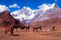
View of the range with Yerupajá in the center
|
|
| Highest point | |
| Peak | Yerupajá |
| Elevation | 6,635 m (21,768 ft) |
| Dimensions | |
| Length | 30 km (19 mi) N-S |
| Geography | |

Location in Peru
|
|
| Country | Peru |
| State/Province | Áncash, Huánuco, Lima |
| Range coordinates | 10°18′S 76°54′W / 10.3°S 76.9°W |
| Parent range | Andes |
The Huayhuash is a stunning mountain range in Peru. It is part of the mighty Andes mountains. The name might come from Quechua words. These words mean "weasel" or "squirrel." This special area became a protected zone in 2002. This helps keep its amazing nature safe. The range stretches across three regions: Ancash, Lima, and Huánuco.
Contents
Discover the Huayhuash Mountains

The Huayhuash mountain range is about 30 kilometers long. It runs from north to south. It has seven peaks that are over 6,000 meters high. One of these is Yerupajá, Peru's second-highest peak. It stands tall at 6,617 metres (21,709 ft).
Another famous peak is Siula. It is 6,344 metres (20,814 ft) high. This peak became well-known from the book Touching the Void. Mountaineer Joe Simpson wrote this book.
Compared to the nearby Cordillera Blanca, Huayhuash has narrower valleys. It also has higher mountain passes. Many smaller peaks surround the ice-covered ones. Several passes here are over 5,000 meters high. Even the valley floors are often higher than 3,000 meters. The green areas of the range are part of the Central Andean wet puna ecoregion.
Few people live in this area. There are only small villages, usually below 4,000 meters. The snowline is around 4,800 meters. The closest villages are Chiquián (3,400 m) and Cajatambo (3,375 m). Some mining used to happen here. A road to the north goes up to 4,750 meters. In 2002, the Peruvian government made Huayhuash a "reserved zone." This stopped new mining and other activities.
Tallest Peaks of Huayhuash


Here are some of the highest peaks in the Huayhuash range:
- Yerupajá, 6,617 metres (21,709 ft)
- Siula, 6,344 metres (20,814 ft)
- Sarapo, 6,127 metres (20,102 ft)
- Jirishanca, 6,094 metres (19,993 ft)
- Yerupaja Chico, 6,089 metres (19,977 ft)
- Rasac, 6,017 metres (19,741 ft)
- Carnicero, 5,960 metres (19,554 ft)
- Rondoy, 5,870 metres (19,259 ft)
- Seria N, 5,860 metres (19,226 ft)
- El Toro, 5,830 metres (19,127 ft)
- Tsacra (or Sacra), 5,774 metres (18,944 ft)
- Mituraju, 5,750 metres (18,865 ft)
- Jurau, 5,674 metres (18,615 ft)
- Trapecio, 5,653 metres (18,547 ft)
- Huacshash, 5,644 metres (18,517 ft)
- Suerococha, 5,625 metres (18,455 ft)
- Huacrish, 5,622 metres (18,445 ft)
- Ninashanca, 5,607 metres (18,396 ft)
- Quesillo, 5,600 metres (18,373 ft)
- Pariauccro, 5,572 metres (18,281 ft)
- Mitopunta, 5,571 metres (18,278 ft)
- Seria Punta, 5,567 metres (18,264 ft)
- Ancocancha, 5,560 metres (18,241 ft)
- Auxilio, 5,560 metres (18,241 ft)
- Cuyoc, 5,550 metres (18,209 ft)
- Huaraca, 5,537 metres (18,166 ft)
- Pumarinri, 5,465 metres (17,930 ft)
- Jirishanca Chico, 5,446 metres (17,867 ft)
- Sueroraju, 5,439 metres (17,844 ft)
- Rajucollota, 5,427 metres (17,805 ft)
- Puscanturpa, 5,400 metres (17,717 ft)
- Jullutahuarco, 5,400 metres (17,717 ft)
- Sarapococha, 5,370 metres (17,618 ft)
- Alcay, 5,300 metres (17,388 ft)
- Paria, 5,190 metres (17,028 ft)
- Suerococha (Ancash), 5,100 metres (16,732 ft)
- Suerococha (Cajatambo), 5,000 metres (16,404 ft)
- Julcán, 4,900 metres (16,076 ft)
- Gasha, 4,880 metres (16,010 ft)
Trekking Adventures in Huayhuash
The Huayhuash range is famous for trekking. The Huayhuash Circuit is a challenging hike. It is much harder than the famous Inca Trail in southern Peru. Fewer people trek here than in the nearby Cordillera Blanca. The circuit usually takes 10 to 14 days. The time depends on the route you choose.
Most of the trek and campsites are above 4,000 meters. This is above the tree line. So, the landscape looks rugged and mountainous. You get amazing views over huge areas. The region is known for its beautiful glacial lakes. You can also find hot springs at Viconga Campsite. You might see Condors, llamas, alpacas, and viscachas.
Trekking is best done in the dry winter months. This is from May to September. The cities of Huaraz and Caraz are good places to start. They are over 100 km away. You can organize your trip and get supplies there. Chiquián used to be the main starting point. But now, buses go deeper into the mountains. They go to the village of Llamaq (3,300 m). Private transport can go as far as Cuartelwain camp. These are now the new starting points for treks.
A more difficult option is the Alpine Circuit. This route goes closer to the peaks. It involves some rock climbing and glacier travel. It takes about 8–10 days to finish.
There are several beautiful lakes in the area. These include Solteracoha (or Solterococha), Siula, Jahuacocha, Carhuacocha, and Sarapococha.
-
Mitucocha camp and Jirishanca (6094 m)
-
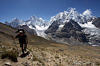
Hiking the Alpine Circuit in the Waywash mountain range. In the background are (L to R) Rasac, Yerupaja, Siula Grande and Sarapo.


Safety in the Huayhuash Range
In the past, the Huayhuash range had some safety concerns. This was due to a group called the Shining Path. They used the area as a remote base until 1992. There were a few incidents involving trekkers. For example, in 2004, some hikers were attacked.
However, things have changed a lot. Local communities now charge a small fee to pass through their lands. This fee helps fund safety measures. Because of this, the area is now generally considered safe for visitors. You can still see the remains of an old Shining Path camp near Lake Viconga. It includes a shooting range and barracks.
Amazing Wildlife and Plants
The Huayhuash area protects high mountain grasslands. It also has patches of special forests. Some native trees here are the Andean alder and trees from the Polylepis family.
Many cool animals live here too. You might spot the giant conebill, a bird with a big beak. There's also the tit-like dacnis and the torrent duck. On land, you might see the Andean mountain cat and the taruca, a type of deer. High in the sky, look for the majestic Andean condor and the fast peregrine falcon. You might also see the giant coot, a large water bird.
See also
 In Spanish: Cordillera Huayhuash para niños
