
Santa River facts for kids
Quick facts for kids Santa River |
|
|---|---|

Satellite image showing the mouth of the Santa River near Chimbote
|
|

Location of mouth
|
|
| Country | Peru |
| Region | Ancash Region |
| Physical characteristics | |
| Main source | 4,050 m (13,290 ft) 10°07′42″S 77°16′59″W / 10.12833°S 77.28306°W |
| River mouth | Pacific Ocean Santa, Peru 8°57′57″S 78°38′05″W / 8.965844°S 78.634712°W |
| Length | 347 km (216 mi) |
| Basin features | |
| Tributaries |
|
The Santa River (Spanish: Río Santa) is an important river in the South American Andes mountains. It flows through the Ancash Region in northwest central Peru.
Contents
River's Journey
Starting Point: Lake Conococha
The Santa River begins at Lake Conococha. This lake is very high up, about 4,050 meters (13,287 feet) above sea level. Small streams from the Cordillera Negra mountains to the west and the snowy Cordillera Blanca mountains to the east feed into Lake Conococha.
The main stream flowing into the lake is the Tuco River. It starts even higher, near Lake Tuco, which is about 5,000 meters (16,404 feet) above sea level. This area is close to the glaciers of Mount Tuco.
Flowing North: Callejón de Huaylas
From Lake Conococha, the Santa River flows north for about 200 kilometers (124 miles). It runs between two mountain ranges: the Cordillera Negra on its west side and the Cordillera Blanca on its east side. This area is known as the fertile Callejón de Huaylas. It's a beautiful valley where many people live and farm.
Turning West: Cañon del Pato
After flowing north, the river changes direction. At about 2,000 meters (6,562 feet) above sea level, it turns west. Here, the river squeezes through a very narrow and impressive gorge called Cañon del Pato, which means "duck's canyon." After this, it breaks through the mountains closer to the coast.
Water Use and the River Mouth
During the dry season, from June to November, the Santa River has less water. But it's still very important! Its water is used for farming (irrigation), for people to drink, and to create electricity using hydroelectric power plants. To help manage the water flow, especially during dry times, some water reservoirs have been built.
The Santa River travels a total of 347 kilometers (216 miles). It finally reaches the Pacific Ocean near a town called Santa. This is about 10 kilometers (6 miles) north of the coastal city of Chimbote. In 1984, tiny bits of gold were found near the river's mouth. This discovery caused a lot of excitement among the local people!
Towns Along the River
Many towns are located along the Santa River, from its start at Lake Conococha to where it meets the ocean. Here are some of them and their approximate elevations:
- 0 km: Conococha (4,050 m elevation)
- 62 km: Recuay (3,400 m)
- 88 km: Huaraz (3,090 m)
- 126 km: Carhuaz (2,650 m)
- 153 km: Yungay, Peru (2,500 m)
- 163 km: Caraz (2,290 m)
- 205 km: Huallanca (1,820 m)
- 215 km: Yuracmarca (1,420 m)
- 343 km: Santa (20 m)
For most of its journey, a paved road runs right alongside the Santa River. This makes it easy to travel through the valley.
Natural Challenges in the Valley
The Santa Valley has faced many natural disasters over the years. Since 1702, when the first flood caused by a glacier was recorded, the valley has seen repeated damage and loss.
In 1941, a big flood destroyed a large part of the city of Huaraz, causing great harm to many people. Later, in 1962 and 1970, huge avalanches of ice and rocks crashed down from the western side of Huascarán mountain. These avalanches roared down the river valley, causing the Santa River to rise by eight meters (26 feet). These events caused widespread destruction and affected thousands of people.
Such powerful landslides will always be a risk in this region. They can happen when large pieces of glacial ice break off. This can cause lakes that are blocked by ice to suddenly drain, sending a mix of mud, ice, and large rocks rushing down the narrow valleys.
Gallery
-
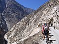
Cañon del Pato

See also
 In Spanish: Río Santa para niños
