Hurricane Francine facts for kids

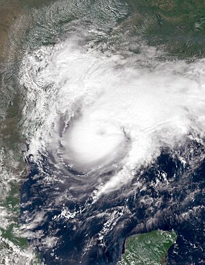
Francine near peak intensity while approaching Louisiana on September 11
|
|
| Meteorological history | |
|---|---|
| Formed | September 9, 2024 |
| Remnant low | September 12, 2024 |
| Dissipated | September 14, 2024 |
| Category 2 tropical cyclone | |
| 1-minute sustained (SSHWS/NWS) | |
| Highest winds | 105 mph (165 km/h) |
| Lowest pressure | 972 mbar (hPa); 28.70 inHg |
| Overall effects | |
| Fatalities | None |
| Damage | $1.3 billion (2024 USD) |
| Areas affected | Eastern Mexico, Gulf Coast of Mexico (particularly Mississippi and Louisiana) |
|
Part of the 2024 Atlantic hurricane season |
|
Hurricane Francine was a powerful tropical cyclone that brought a lot of rain and flooding to parts of the Gulf Coast of Mexico. It especially affected Louisiana in September 2024. Francine was the sixth named storm and fourth hurricane of the 2024 Atlantic hurricane season. Its formation ended a quiet period for storms in the Atlantic Ocean.
Francine started as a tropical wave in the central Atlantic in late August. It slowly became more organized as it moved. By September 7, it was near the Yucatán Peninsula and entered the Bay of Campeche. On September 9, it officially became Tropical Storm Francine. The storm grew stronger and became a Category 2 hurricane. It hit Louisiana on September 11 with winds of 105 miles per hour (169 km/h). This caused significant damage in Louisiana and Mississippi. Francine then quickly weakened into a tropical storm and later a tropical depression. It completely disappeared by September 14.
Heavy rain from Francine caused flooding in parts of northeastern Mexico. Oil and natural gas production in the Gulf of Mexico was also stopped for a time. About 500,000 homes in Louisiana, Mississippi, and Alabama lost electricity. This happened because Francine knocked down many power lines and trees. In Louisiana, strong winds and falling trees damaged hundreds of buildings. The most rain, 14.61 inches (371 mm), fell near Navarre, Florida. Experts estimated that Francine caused about $1.3 billion in damage.
Contents
Understanding Hurricane Francine
How Francine Formed and Moved
Hurricane Francine began as a tropical wave that moved off the coast of Africa on August 25. This wave slowly traveled across the Atlantic Ocean. As it moved, it sometimes had disorganized clouds and thunderstorms. By September 2, the wave reached the Lesser Antilles. It then sped up as it moved across the Caribbean Sea.
On September 7, the northern part of the wave moved over the Yucatan Peninsula and into the Bay of Campeche. Here, a new area of low pressure formed. This system quickly gained strength. On September 8, it was named Potential Tropical Cyclone Six. The next day, it became Tropical Storm Francine. It was located southeast of the mouth of the Rio Grande.
A weather system over Florida guided Francine slowly northwestward. This brought heavy rain to northern Mexico and southern Texas. On September 10, the storm turned sharply northeast. It was moving ahead of another weather system over the southern United States.
On September 11, Francine became a hurricane. It was over warm waters and had light winds high in the atmosphere. The hurricane sped up and developed an eye as it got closer to Louisiana. Hurricane Francine made landfall in Louisiana at 22:00 UTC on September 11. It hit about 25 miles (40 km) southwest of Morgan City, Louisiana, as a Category 2 hurricane. Its winds were 105 miles per hour (169 km/h).
After hitting land, Francine quickly weakened. It became a tropical storm by the time it reached Lake Pontchartrain on September 12. Later that day, it weakened further into a tropical depression over central Mississippi. By September 14, Francine had completely disappeared over southeastern Arkansas.
Getting Ready for the Storm
Mexico's Preparations
As Francine approached, parts of Mexico prepared for the storm. Tropical storm watches were put in place along the coast from Barra del Tordo to the mouth of the Rio Grande. Other areas in northeastern Mexico received tropical storm warnings. The state of Tamaulipas closed schools in Matamoros, San Fernando, and Valle Hermoso.
United States Prepares
Companies like ExxonMobil and Shell stopped their work in the Gulf of Mexico. They moved their employees to safety. Amtrak changed or stopped train services to New Orleans from September 11 to 18.
Louisiana's Response
Hurricane warnings were issued for the Louisiana coast from Sabine Pass to Morgan City. The governor declared a state of emergency. This allowed the state to use emergency resources. The governor also sent 2,300 members of the Louisiana National Guard to help in areas expected to be hit. Many school districts in Louisiana closed.
Some areas, like Grand Isle, Lafitte, and Barataria, had mandatory evacuations. This meant people had to leave their homes for safety. Other areas, including Lafourche, Terrebonne, and Washington Parishes, set curfews. St. Mary and Terrebonne Parishes closed their floodgates to prevent flooding. Iberia Parish and Baton Rouge gave out sandbags to help residents protect their homes.
Louis Armstrong International Airport canceled all flights. Five USPS locations also closed. Port Fourchon, an important port for offshore oil, and the Louisiana Offshore Oil Port were shut down. Two national historic parks in southern Louisiana also closed as the hurricane got closer.
Other States' Actions
South Texas was under a tropical storm warning. Galveston County raised its emergency alert level. Governor Greg Abbott sent water rescue teams to help.
The coasts of Mississippi and Alabama also received tropical storm warnings. The Governor of Mississippi Tate Reeves declared a state of emergency. Jackson, Mississippi, opened a shelter for people needing a safe place. Several schools in Mississippi closed because of Francine.
Francine's Effects and Damage
Impact in Mexico
In Matamoros, Mexico, several areas flooded due to 200 millimeters (7.9 inches) of rain. This caused schools to close. The Mexican Government provided aid to the affected areas. Water pumps were used across the city to remove floodwaters.
| State | Total rainfall |
|---|---|
| Alabama | 13.65 in (347 mm) |
| Florida | 14.61 in (371 mm) |
| Georgia | 7.69 in (195 mm) |
| Louisiana | 11.93 in (303 mm) |
| Mississippi | 8.63 in (219 mm) |
| Missouri | 3.47 in (88 mm) |
| Oklahoma | 6.58 in (167 mm) |
| Tennessee | 9.16 in (233 mm) |
| Texas | 7.44 in (189 mm) |
|
|
|
Damage Across the United States
The National Centers for Environmental Information estimated that Francine caused about $1.3 billion in damage across the United States. The storm also stopped 39% of oil and natural gas production in the Gulf of Mexico. This reduction caused crude oil prices to increase by 2% on September 11.
Texas Experiences Flooding
By September 9, Port O'Connor was already experiencing flooding. Winds gusted up to 38 miles per hour (61 km/h) in Brownsville. The highest rainfall in Texas was 7.44 inches (189 mm) in Brownsville. Flooding made the SpaceX Starbase difficult to reach.
Louisiana's Major Challenges
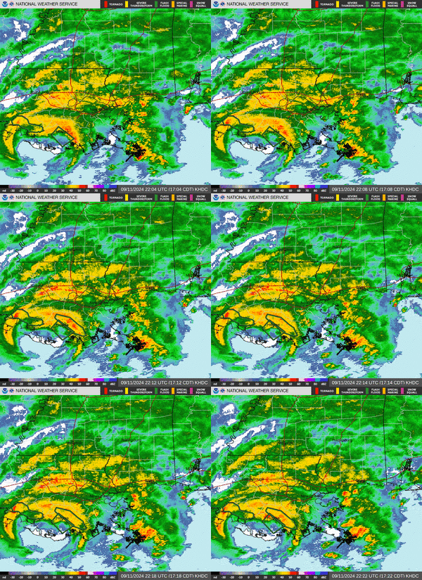
Francine hit Southern Louisiana with strong winds of 105 miles per hour (169 km/h). The storm surge, which is when sea level rises above normal, was about 8 feet (2.4 meters). Livingston saw a storm surge of 2 feet (0.61 meters) from Lake Maurepas. A tornado warning was issued for Plaquemines Parish. The New Orleans area received 7 inches (180 mm) of rain.
About 450,000 people lost power, mostly due to fallen trees and power lines. Around 500 people went to emergency shelters. Many roads were blocked by fallen trees and debris. Heavy rainfall caused widespread street flooding. More than 500 homes in Jefferson Parish were damaged. In Iberville Parish, 352 waterways were blocked. New Orleans's wastewater system had problems, and people were asked to limit their water use. Several rivers in Saint Tammany Parish overflowed.
Rescue teams helped many people trapped by rising floodwaters. For example, in Lafourche Parish, the Sheriff’s Office rescued residents, including children, from flooded homes. A brave person in New Orleans rescued another individual from a sinking truck during the flooding. Two other people were injured by falling trees. Francine also caused many fish to die in canals and bayous because the water lost too much oxygen.
The federal government approved a FEMA declaration to help with recovery. Damage estimates ranged from $1.5 billion to over $9 billion. As of early 2025, the damage was estimated at US$1.3 billion. After the storm, new pumping systems were planned for Morgan City to help prevent future flooding.
Mississippi's Storm Experience
Strong winds hit the Mississippi Coast on September 12. The Jackson County Office of Emergency Services reported minor damage. This included power outages, downed trees, and flooded streets. As Francine moved north and weakened, it brought heavy rain to Jackson and central Mississippi. Southern Mississippi faced significant flooding. Other parts of the state also had fallen trees and power lines. On the morning of September 12, 60,000 customers in Mississippi lost power. About 500 people stayed in state shelters. One person was injured in Jones County. The strongest wind gust was 49 miles per hour (79 km/h) in Gulfport. The most rain was 3.98 inches (10.1 cm) in Madison County.
Effects in Other Areas
In Alabama, 39,000 power outages were reported. Trees and power lines also fell in the western part of the state. Winds reached 44 miles per hour (71 km/h) in Bon Secour. Danville received 13.65 inches (347 mm) of rain.
The Florida Panhandle also experienced tropical storm conditions. Winds reached 44 miles per hour (71 km/h) at Pensacola Beach, with gusts up to 51 miles per hour (82 km/h). The highest rainfall in Florida was 14.61 inches (371 mm) in Navarre. Tennessee also had several days of rainstorms.
Learn More About Storms
- Weather of 2024
- Tropical cyclones in 2024
- Timeline of the 2024 Atlantic hurricane season
- List of Category 2 Atlantic hurricanes
- List of Louisiana hurricanes (2000–present)
- Hurricane Zeta (2020) – followed a similar track
- Hurricane Nicholas (2021) – followed a similar track


