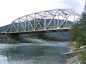
Illecillewaet River facts for kids
Quick facts for kids Illecillewaet River |
|
|---|---|
| Country | Canada |
| Province | British Columbia |
| Physical characteristics | |
| Main source | Illecillewaet Glacier Glacier National Park |
| River mouth | Columbia River Revelstoke 50°58′55″N 118°12′25″W / 50.98194°N 118.20694°W |
| Length | 62 km (39 mi) |
| Basin features | |
| Basin size | 1,202 km2 (464 sq mi) |
The Illecillewaet River is a river in British Columbia, Canada. It is like a long stream that flows into the bigger Columbia River. This river starts high up at the Illecillewaet Glacier in Glacier National Park. It flows for about 62 kilometers (38 miles) to the southwest. Eventually, it joins the northern part of Upper Arrow Lake near the town of Revelstoke. The area that drains into this river is about 1,202 square kilometers (464 square miles).
History of the Illecillewaet River
The Illecillewaet River has been very important for a long time. In 1881, people discovered a way to cross the Selkirk Mountains by following this river. This path is now known as Rogers Pass. A surveyor named Albert Bowman Rogers found this pass while working for the Canadian Pacific Railway.
This pass became the route for Canada's first transcontinental railway. This railway connected the country from one side to the other. Later, in 1962, the Trans-Canada Highway was built. It also followed the Illecillewaet River west of Rogers Pass.
Natural History and Parks
The land around the Illecillewaet River was quickly seen as very special for its natural environment. Because of this, Glacier National Park was created in the area in 1886. Later, Mount Revelstoke National Park was also established in 1914. These parks help protect the unique plants and animals that live in the river's watershed.
See also
 In Spanish: Río Illecillewaet para niños
 | Charles R. Drew |
 | Benjamin Banneker |
 | Jane C. Wright |
 | Roger Arliner Young |


