Illecillewaet Glacier facts for kids
Quick facts for kids Illecillewaet Glacier |
|
|---|---|
| Great Glacier | |
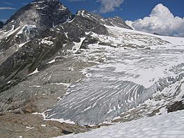
Northern terminus of glacier in July 2006
|
|
| Type | Alpine |
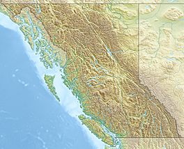
| Location | Selkirk Mountains, British Columbia, Canada |
| Coordinates | 51°14′12″N 117°26′30″W / 51.23667°N 117.44167°W |
| Area | 8.83 square kilometres (3.41 sq mi) |
| Status | Retreating |
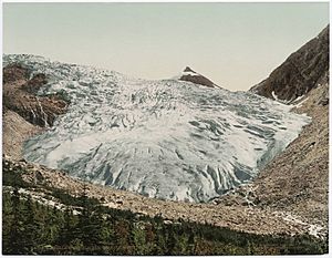
The Illecillewaet Glacier is a large ice mass found in British Columbia, Canada. It is located within Glacier National Park. This park is part of the Selkirk Mountains, which are a section of the larger Columbia Mountains.
After a railway was built nearby, and a hotel opened, the glacier became a popular spot for tourists. It was easy to reach by road and train. This made it one of the most studied glaciers in North America. Scientists have carefully recorded how much it has shrunk over the last 100 years.
Contents
What Makes the Glacier Special?
The Illecillewaet Glacier is located south of Mount Sir Donald. This is in the Selkirk Mountains, west of Rogers Pass. Water flowing from the glacier forms the start of the Illecillewaet River.
The glacier's main snowfield, called a névé, also feeds three other glaciers. These are the Asulkan, Geikie, and Deville glaciers. In 2002, the area where snow builds up (the accumulation area) was about 4.92 square kilometres (1.90 sq mi). The area where ice melts (the ablation area) was about 3.91 square kilometres (1.51 sq mi). This makes the total size of the glacier about 8.83 square kilometres (3.41 sq mi).
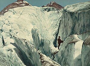
Scientists estimate its average depth is about 100 metres (330 ft). Its highest point is around 2,800 metres (9,200 ft). You can see how the glacier has pulled away pieces of rock (a process called glacial plucking) on the bedrock below its end.
A Look Back in Time: The Glacier's History
Railways and Hotels: Early Tourism
Even though First Nations people lived in nearby valleys, no signs of their settlements have been found right around the Illecillewaet area. The first European to visit the glacier was Major A.B. Rogers. He was a railway surveyor who explored the area in 1882 and 1883. He was looking for a good path for a railway.
When the Canadian Pacific Railway (CPR) finished its transcontinental line through Rogers Pass in 1885, the glacier became a top tourist spot. Glacier National Park was created in 1886. That same year, a small hotel called Glacier House was built near the glacier's end. The hotel grew bigger in 1892 and 1904. By 1907, people called the Illecillewaet the "most visited glacier in the Americas."
At first, the CPR called it the "Great Glacier." The name "Illecillewaet" comes from the Okanagan First Nations word for "big water." This name was first used for the river, then for the glacier. It slowly replaced "Great Glacier" and was officially adopted by Parks Canada in the 1960s.
Many visitors came to the glacier, including mountain climbers and glaciologists. Glaciologists are scientists who study glaciers. The first recorded climb of the glacier was in 1901 by A. O. Wheeler, Edward Feuz, and Charles Clarke. Wheeler and the Alpine Club of Canada built a hut nearby for climbers. Edward Feuz was one of several Swiss guides hired by the CPR. They helped visitors explore the glacier and climb nearby mountains.
The Vaux Family: Early Glacier Scientists
The Vaux family was a wealthy family from Pennsylvania. They first visited Glacier House and the Illecillewaet Glacier in 1887. On a later trip, they noticed the glacier's end had clearly moved back.
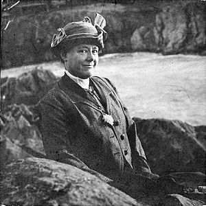
The Vaux children, William, George Jr., and Mary (who later became Mary Vaux Walcott), loved photography. They started studying the glacier by taking pictures from the same spots each time. William and George Jr. shared their findings with the National Academy of Sciences in the U.S. Their study was seen as a big step forward in the new field of glaciology. Mary Vaux continued to visit the area every summer until she passed away in 1940.
The Vaux family took many careful photos of the glacier and the area around it. They first used glass plates for their cameras, which were heavy to carry. Later, they used more modern cameras. Their photos and scientific measurements showed how the glacier was changing. George Vaux Jr.'s grandson, Henry Vaux Jr., also a photographer, noted how little the mountain area had changed over time. The biggest differences between then and now are the glacier's retreat and the presence of the Trans-Canada Highway. He saw trees that his grandfather had photographed from the same spot, showing how much the glaciers had shrunk.
The Trans-Canada Highway: A New Era
In 1916, the CPR built the Connaught Tunnel. This tunnel bypassed the Glacier House area. Because of this, fewer visitors came, and the hotel closed in 1925. It was torn down in 1929. For about 30 years, the once-popular glacier was mostly forgotten.
Then, in 1962, the new Trans Canada Highway was finished. Its route followed the old CPR line closely. Once again, the Illecillewaet Glacier was connected to a major travel route. Parks Canada started to improve things for visitors. The Illecillewaet campground opened, and new trails were built. These trails helped people reach the glacier, which was now much farther away. In the later half of the century, more studies were done as the glacier's shrinking became more obvious.
Studying the Glacier's Changes
While there have been more studies of European glaciers, the research on Illecillewaet is very detailed for North America. The first scientific study was done by the Vaux family from 1887 to 1912. George, William, and Mary Vaux, along with others, measured how much the glacier was shrinking. They mostly used annual photos taken from fixed points.
During World War I and the Great Depression, fewer observations were made. The closing of Glacier House in 1925 greatly reduced the number of visitors. A government agency called the Dominion Water and Power Bureau started measuring the glacier in 1945. They did yearly studies from 1945 to 1950, and then every two years until 1960. No measurements were taken from 1960 to 1972. After that, Parks Canada began surveying again.
In 1996, a study began that looked at rock lichen to figure out how much the glacier had retreated. Satellite imagery has also been used to measure the glacier's size from space.
The Glacier is Shrinking
Since scientists began studying it in the late 1800s, the Illecillewaet Glacier has been shrinking. There have been short times when it grew a little, but mostly it has gotten smaller. Between 1887 and 1962, the end of the glacier moved back almost 1.5 km (0.93 mi).
Parks Canada research shows that it advanced about 100 m (330 ft) between 1972 and 1986. However, overall, the glacier retreated a total of 1,433 m (4,701 ft) from 1887 to 1984. By 1951, the glacier had lost about 28% of its total mass. It only gained back about 1% by 1986.
 | Jewel Prestage |
 | Ella Baker |
 | Fannie Lou Hamer |


