Mount Sir Donald facts for kids
Quick facts for kids Mount Sir Donald |
|
|---|---|

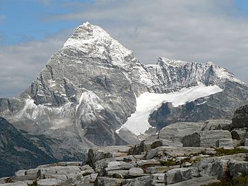
Mount Sir Donald from Abbott Ridge
|
|
| Highest point | |
| Elevation | 3,284 m (10,774 ft) |
| Prominence | 874 m (2,867 ft) |
| Parent peak | Mount Dawson |
| Geography | |
| Parent range | Selkirk Mountains |
| Topo map | NTS 82N6 |
| Climbing | |
| First ascent | Emil Huber, Carl Sulzer, Harry Cooper, 1890 |
Mount Sir Donald is a tall mountain in British Columbia, Canada. It stands 3,284 meters (about 10,774 feet) high. You can find it in Glacier National Park, near Rogers Pass. This park is part of the Selkirk Mountains.
The mountain looks a bit like the famous Matterhorn mountain. Its strong rocks make it a favorite spot for rock climbers. A climbing path called the Northwest Arete is very well-known. It is even in a famous book called Fifty Classic Climbs of North America.
Mountain's Name
Mount Sir Donald was first called Syndicate Peak. This name honored the group of people who helped pay for the Canadian Pacific Railway. This railway was a huge project that connected Canada from east to west.
Later, the mountain was renamed. It got its new name from Donald Smith, 1st Baron Strathcona and Mount Royal. He was the leader of the group that funded the railway.
First Climbers
The first people to climb Mount Sir Donald reached its top in 1890. These climbers were Emil Huber and Carl Sulzer from Switzerland. They were joined by a porter named Harry Cooper. A porter is someone who helps carry supplies.
By the 1910s, about three or four groups climbed the mountain each year. This shows how popular it was even back then.
Weather and Water
Mount Sir Donald has a subarctic climate. This means it has very cold, snowy winters. The summers are usually mild, not too hot. Temperatures can drop below -20 °C (which is -4 °F). With wind chill, it can feel even colder, below -30 °C (-22 °F).
Rain and melting snow from the mountain flow in two directions. Some water drains west into the Illecillewaet River. Other water flows east into the Beaver River.
 | Isaac Myers |
 | D. Hamilton Jackson |
 | A. Philip Randolph |


