
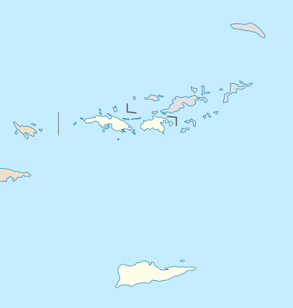
Image: USA Virgin Islands location map

Size of this PNG preview of this SVG file: 570 × 599 pixels. Other resolution: 228 × 240 pixels.
Original image (SVG file, nominally 787 × 827 pixels, file size: 51 KB)
Description: Location map of the United States Virgin Islands, USA
Title: USA Virgin Islands location map
Credit: own work, using United States National Imagery and Mapping Agency data U.S. Geological Survey (USGS) data
Author: NordNordWest
Usage Terms: Creative Commons Attribution-Share Alike 3.0
License: CC BY-SA 3.0
License Link: https://creativecommons.org/licenses/by-sa/3.0
Attribution Required?: Yes
Image usage
The following 32 pages link to this image:
- Buck Island National Wildlife Refuge
- Buck Island Reef National Monument
- Capella Island
- Carvel Rock (United States Virgin Islands)
- Cas Cay
- Christiansted National Historic Site
- Cinnamon Cay
- Flanagan Island
- Fort Frederik
- Great Saint James, U.S. Virgin Islands
- Green Cay National Wildlife Refuge
- Henley Cay
- Inner Brass, U.S. Virgin Islands
- Kalkun Cay, United States Virgin Islands
- Leduck Island
- Outer Brass, U.S. Virgin Islands
- Protestant Cay
- Ramgoat Cay, United States Virgin Islands
- Ruth Island
- Saba Island, United States Virgin Islands
- Saint Croix
- Saint John, U.S. Virgin Islands
- Saint Thomas, U.S. Virgin Islands
- Savana Island, U.S. Virgin Islands
- Shark Island, United States Virgin Islands
- Steven Cay, United States Virgin Islands
- Thatch Cay, U.S. Virgin Islands
- Trunk Cay, United States Virgin Islands
- Turtledove Cay, United States Virgin Islands
- Virgin Islands National Park
- Water Island, U.S. Virgin Islands
- Whistling Cay, United States Virgin Islands

All content from Kiddle encyclopedia articles (including the article images and facts) can be freely used under Attribution-ShareAlike license, unless stated otherwise.