Inchgarvie facts for kids
| OS grid reference | NT138795 |
|---|---|
| Coordinates | 56°02′N 3°14′W / 56.03°N 3.23°W |
| Physical geography | |
| Island group | Firth of Forth |
| Area | 0.83 hectares (89,340 sq ft) |
| Highest elevation | 19 metres (62 ft) |
| Administration | |
| Sovereign state | United Kingdom |
| Country | Scotland |
| Council area | City of Edinburgh |

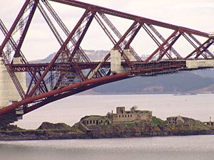
Inchgarvie is a small, empty island in the Firth of Forth. It's famous because four large concrete structures, called caissons, sit on the rocks around it. These caissons are the strong foundations for the huge Forth Bridge.
Long ago, before modern roads, boats were the main way to cross the Firth of Forth. Inchgarvie was right on the busy path between North Queensferry in Fife and South Queensferry in Lothian. This made it a very important place for defence. Even though no one lives there now, people have lived on Inchgarvie at different times in history, starting in the late 1400s.
From far away, Inchgarvie looks a bit like a small warship because of its shape and colour. It even had guns to protect the coast from 1901 to 1906, and again from 1908 until the 1930s.
Contents
What's in a Name?
The name Inchgarvie comes from the Gaelic language. It probably means "rough island" or "island of the rough place."
There's an older idea that the name comes from the Scots word "garvie," which is another name for a small fish called a sprat. People used to fish for sprats in the inner Forth until it was stopped in 1983.
Island History
Some old records mention Danish attacks on nearby islands like Inchcolm, and also on the areas of Fife and Lothian. This might mean Inchgarvie was used by the Danes in some way a long time ago.
Building a Fort
In 1491, King James IV gave permission for a man named John Dundas to build a fort on the island. But John Dundas didn't build it. So, in 1513, King James IV himself ordered a strong tower to be built there.
After the king died, Margaret, the widow of William Dundas, helped finish the fort in 1514. A man named Charles Dennison was the captain of Inchgarvie. He managed a large team of builders, including masons and labourers. They even had two boats to help with the work. By 1515, the island had guns and a "blawing horne," which was like a signal horn. There was also a small chapel on the island.
Captured and Destroyed
In 1544, during an attack on Edinburgh, an English ship captured the fort on Inchgarvie. It was then torn down a week later. The English commander, Lord Hertford, thought it would be useful to keep the fort, but his orders from King Henry VIII didn't allow it. A few years later, in 1547, other nearby islands were fortified by the English. Inchgarvie might have been fortified then too.
Prison and Defence
From 1519 to 1671, the castle on Inchgarvie was used as a prison. In 1580, Inchkeith and Inchgarvie were even used as places to send people who had the plague, to keep them away from others. Inchgarvie also had a hospital for quarantine and a prison. Later, Oliver Cromwell ordered it to be torn down.
During the time of King Charles II, the island was still kept up for defence. King Charles II even visited it in 1651. But after his army lost a battle, the island fell into disrepair.
In 1707, the island was rented out. Then, in 1779, the island's defences were rebuilt again. This was because of a threat from John Paul Jones, an American Naval Commander who was bothering British ships from a base in the Forth. Luckily, these new defences were never actually used in a battle.
During the time of Napoleon, more gun batteries were added in 1806 because of the danger from the sea.
The Forth Bridge Connection
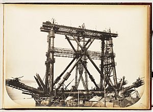
In 1878, work began on the foundations for an earlier design of the Forth Bridge by Thomas Bouch. These foundations are still on Inchgarvie. However, after the terrible Tay Bridge disaster, these plans were stopped.
Later, the west side of Inchgarvie was extended with a pier. This became the foundation for one of the giant cantilever sections of the current Forth Bridge. Because it was so close to the bridge construction, Inchgarvie was also used as an office for the project. The old castle buildings were re-roofed and used as homes for the workers. Some of the stone from the old castle was even used to help build the caissons for the Forth Bridge.
Modern Defence Operations
Inchgarvie became important for protecting the Firth of Forth again in the early 1900s. In 1901, it was armed with two 12-pounder guns. These guns worked with other gun positions on the mainland to the north and south. Even though the island's guns were removed in 1906, they were put back in 1908. By the start of the First World War, the number of guns was increased to four.
The guns were removed from the Forth's approved defences in the early 1930s. They might have been used for practice until the start of the Second World War. During the Second World War, the island was only armed with machine guns. The island's defences were meant to cover a controlled minefield across the river. Later, they were designed to stop fast torpedo boats trying to enter the naval base or damage the lock gates at Rosyth Dockyard.
Island's Rocks
Inchgarvie was formed by volcanic rock and is partly made of a type of rock called picrite. Studies of the seabed around the island show that the part of Inchgarvie we see is just the top of a larger "crag and tail" shape. This shape was created by glaciers moving across the land long ago, similar to how Edinburgh Castle and the Royal Mile were formed.
 | Calvin Brent |
 | Walter T. Bailey |
 | Martha Cassell Thompson |
 | Alberta Jeannette Cassell |


