
Independence, Wisconsin facts for kids
Quick facts for kids
Independence, Wisconsin
|
|
|---|---|
 |
|

Location of Independence in Trempealeau County, Wisconsin.
|
|
| Country | |
| State | |
| County | Trempealeau |
| Area | |
| • Total | 4.22 sq mi (10.93 km2) |
| • Land | 4.16 sq mi (10.78 km2) |
| • Water | 0.06 sq mi (0.14 km2) |
| Elevation | 781 ft (238 m) |
| Population
(2020)
|
|
| • Total | 1,498 |
| • Density | 359.8/sq mi (138.9/km2) |
| Time zone | UTC-6 (Central (CST)) |
| • Summer (DST) | UTC-5 (CDT) |
| Area code(s) | 715 & 534 |
| FIPS code | 55-36800 |
| GNIS feature ID | 1583429 |
Independence is a city in Trempealeau County, Wisconsin, United States. In 2020, about 1,498 people lived there. The city is located where two waterways, Elk Creek and the Trempealeau River, meet.
Contents
History of Independence
The story of Independence comes from a local history book published in 1976. This book was created for the city's 100th birthday.
Independence is located in the Town of Burnside. This area was set up under a land law from 1785. Around 1863, many settlers from Europe and the Eastern United States began to arrive.
How Independence Started
.jpg)
The city of Independence exists thanks to a railroad and a man named David M. Kelly. A railroad line, the Green Bay and Western Railroad, runs near the Trempealeau River. This line was planned to go from Green Bay, Wisconsin to Wabasha, Minnesota. David M. Kelly really wanted a train station, called a depot, built in Burnside.
There was a lot of disagreement about where to put the depot. Finally, the railroad company agreed to build it if the local people could raise $5,000. The money was raised, and Kelly bought the land for the depot in 1876. He then started a village on this land. He named it Independence to celebrate the United States' 100th birthday. The village officially became a village in 1885 and then a city in 1942.
The Railroad's Role
The train depot that was once central to Independence is no longer there. The train line started in Green Bay but ended up reaching Winona, Minnesota instead of Wabasha. Carrying passengers by train was never very profitable. As more people started using cars, passenger train service ended in 1949. However, freight trains still use the line today to carry goods.
Geography of Independence

Independence covers about 4.22 square miles (10.93 square kilometers). Most of this area, about 4.16 square miles (10.78 square kilometers), is land. A small part, about 0.06 square miles (0.14 square kilometers), is water. The city is located in the Driftless Zone of the Midwest. This area was not flattened by glaciers during the last Ice Age.
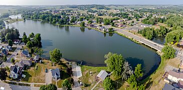
Bugle Lake and Dam
Just upstream from where Elk Creek and the Trempealeau River meet is a dam. This dam creates Bugle Lake. The current dam was built in 1935 as part of a government project called the Works Progress Administration. It replaced an older dam built by a resident named W.S. Newton. Bugle Lake is a peaceful place for canoeing. There is also a small park on an island in the lake.
Population and People
| Historical population | |||
|---|---|---|---|
| Census | Pop. | %± | |
| 1880 | 365 | — | |
| 1890 | 382 | 4.7% | |
| 1900 | 630 | 64.9% | |
| 1910 | 664 | 5.4% | |
| 1920 | 805 | 21.2% | |
| 1930 | 866 | 7.6% | |
| 1940 | 1,036 | 19.6% | |
| 1950 | 1,088 | 5.0% | |
| 1960 | 954 | −12.3% | |
| 1970 | 1,036 | 8.6% | |
| 1980 | 1,180 | 13.9% | |
| 1990 | 1,041 | −11.8% | |
| 2000 | 1,244 | 19.5% | |
| 2010 | 1,336 | 7.4% | |
| 2020 | 1,498 | 12.1% | |
| U.S. Decennial Census | |||
The United States Census Bureau collects information about people living in cities. This helps us understand how the population changes over time.
2020 Census Information
According to the census of 2020, Independence had 1,498 people. This means there were about 359.8 people per square mile. There were 681 homes in the city.
The census also looks at the different groups of people living in the city.
- About 68.6% of the people were White.
- About 1.8% were Native American.
- About 1.0% were Black or African American.
- About 0.3% were Asian.
- About 17.4% were from other races.
- About 10.9% were from two or more races.
- About 32.3% of the population identified as Hispanic or Latino.
2010 Census Information
In the census of 2010, there were 1,336 people living in Independence. There were 606 households, which means groups of people living together in one home. About 352 of these were families.
The average age of people in the city was 37.7 years.
- About 22.3% of residents were under 18 years old.
- About 10.4% were between 18 and 24 years old.
- About 25.6% were between 25 and 44 years old.
- About 25% were between 45 and 64 years old.
- About 16.7% were 65 years or older.
The city had slightly more males (51.9%) than females (48.1%).
Notable People from Independence
Some important people have come from Independence:
- Grover L. Broadfoot: He was a chief justice, which is a top judge, for the Wisconsin Supreme Court.
- Leo Ferdinand Dworschak: He was a Roman Catholic Bishop for the Roman Catholic Diocese of Fargo.
- George H. Markham: He served as a Wisconsin State Representative.
- William H. Markham: He served as a Wisconsin State Senator.
Gallery
-
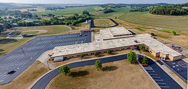
Independence schools
-
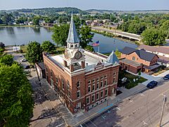
Independence City Hall and library
-
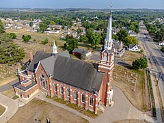
Independence Church SS Peter & Paul Catholic Church
-
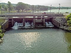
Bugle Lake dam
-
Bugle Lake


See also
 In Spanish: Independence (Wisconsin) para niños
