
Independence Rock facts for kids
|
Independence Rock
|
|
 |
|

Location in Wyoming

Location in the United States
|
|
| Location | 60 mi (97 km) SW of Casper on WYO 220, Natrona County, Wyoming |
|---|---|
| Area | 170 acres (69 ha) |
| NRHP reference No. | 66000757 |
Quick facts for kids Significant dates |
|
| Added to NRHP | October 15, 1966 |
| Designated NHL | January 20, 1961 |
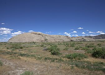
Independence Rock is a huge granite rock in Wyoming. It stands about 130 feet (40 m) tall. It is also 1,900 feet (580 m) long and 850 feet (260 m) wide. You can find it in southwestern Natrona County, Wyoming.
This rock was a very important landmark in the 1800s. It guided pioneers traveling west. These travelers used trails like the Oregon Trail, Mormon Trail, and California Trail. Many people carved their names into the rock. An explorer named Father Pierre-Jean De Smet called it the Register of the Desert in 1840.
Today, Independence Rock is a National Historic Landmark. It became one on January 20, 1961. It is now part of the Independence Rock State Historic Site. The state of Wyoming owns and takes care of it.
Contents
What is Independence Rock?
Independence Rock is a giant, rounded rock. It is made of granite, a very hard stone. This type of rock is common in the Granite Mountains. The rock looks a bit like Uluru in Australia, but it is smaller.
It sits in a high, flat area in central Wyoming. The Sweetwater River is nearby. You can visit the rock from Wyoming Highway 220. It is about 20 miles (32 km) from Muddy Gap. It is also about 60 miles (97 km) southwest of Casper.
History of Independence Rock
Why is it called Independence Rock?
The rock got its name because of its location on the Emigrant Trail. Pioneer families traveled in wagons. They usually left the Missouri River in spring. Their goal was to reach the rock by July 4th. This date is Independence Day in the United States. Reaching the rock by then meant they could get to their new homes before winter snows. The name was likely used before 1830.
Famous Visitors and Carvings
John C. Frémont was an explorer. He camped near the rock on August 1, 1843. He wrote about the many names carved on it. He noted that names of famous people were there. Scientists and traders had also left their mark.
Frémont himself carved a large cross into the rock. But on July 4, 1847, many pioneers gathered there. They blasted off the cross. Some people at the time saw the cross as a symbol of the Pope. Frémont was actually a member of the United States Episcopal Church.
A Special Meeting Place
On July 4, 1862, Independence Rock hosted a special event. It was the site of Wyoming's first Masonic Lodge meeting. This shows how important the rock was to early settlers.
Gallery
-
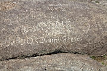
Names carved on Independence Rock, including R. McCord in 1850.
-
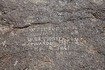
More names carved on Independence Rock, like W.R.R. Thompson and J. Ware from 1861.
-
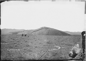
Independence Rock as it looked in 1870.
-
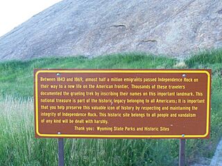
A sign at Independence Rock explaining its history, taken in 2011.
-
Independence Rock in 2015.


