Indian Brook Road Historic District facts for kids
Quick facts for kids |
|
|
Indian Brook Road Historic District
|
|

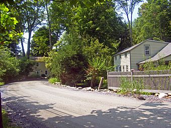
"The Bend", near west end of district, 2008
|
|
| Location | Garrison, NY |
|---|---|
| Nearest city | Peekskill |
| Area | 30 acres (12 ha) |
| Built | 1783-1940 |
| NRHP reference No. | 93000853 |
| Added to NRHP | August 19, 1993 |
The Indian Brook Road Historic District is a special area located near Garrison, in New York State. It's found where Indian Brook Road meets US 9. This district covers about 30 acres (12 hectares) and has 15 buildings. Most of these buildings are important because they help tell the story of the area's past.
For a long time, from the late 1700s to the mid-1900s, this area was a small country village. It was first known as Warrens, and later as Nelson's Corner. Unlike many other small villages, this one has kept its original layout and most of its old buildings. It survived big changes like the growth of factories and the invention of cars. In 1993, this special area was officially named a historic district. It was then added to the National Register of Historic Places, which is a list of places important to American history.
Contents
Exploring the District's Location
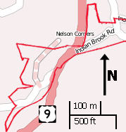
The Indian Brook Road Historic District is made up of two main parts. These parts are connected by a small section of Route 9. The boundaries of the district show how big Nelson's Corner was when it was busiest in the late 1800s. It includes ten different land plots.
Nature and Buildings in the District
The land in the district has many tall trees that shade the buildings. Most of the buildings are wooden houses and other structures, usually no taller than two stories. The Indian Brook, which flows into the Hudson River, runs very close to the road. Part of the brook is even considered a historic feature because of an old mill pond that was once there. The whole area is surrounded by the smaller hills of the Hudson Highlands.
Important Spots on Route 9
On the east side of US 9, the district includes a small part of Old Albany Post Road. This road is very old and important for local transportation. It's one of the oldest dirt roads still used in the United States. At this spot, you'll find the Bird and Bottle Inn. This inn was an old tavern from the early days of Nelson's Corner. It still has a small part of its original building. The district also stretches west to a former intersection called "The Bend." It includes a large piece of land that goes up the slopes of Cat Hill.
A Look Back in Time: The District's History
The 1800s: From Rest Stop to Hamlet
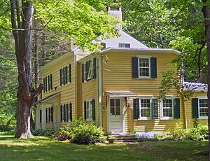
Around the time of the American Revolution, Samuel Warren's home became a well-known place for travelers to stop and rest. It was along the Albany Post Road, and the area even appeared on maps as "Warrens." In the early 1800s, Samuel's son, John Warren, rented a large farm of 411 acres (166 hectares). This farm included the entire area of the current historic district. John's house, which is now the Bird and Bottle Inn, also served as a tavern for travelers. Samuel's other son, Samuel Jr., built a house for his family just west of the highway. Both of these houses are important parts of the district. They were built in a simple, traditional style common for people of English descent in America at that time.
In 1804, a new road called the Highlands Turnpike opened. It was a flatter way to travel than the Post Road and is now mostly followed by US 9. In the village, this new road went slightly differently. It followed Indian Brook down to a four-way crossing called "The Bend." From there, an old, unused road went south over the brook.
John Warren couldn't actually buy his land until 1821. This was after a problem was solved with the heirs of Frederick Philipse, a local landowner. Philipse's land had been taken by the state because he supported the British during the Revolution. The deal meant that all rented lands had to be sold.
Sometime in the early 1800s, John Warren built a dam on Indian Brook. This created a mill and a pond. It helped make his property more valuable. This was the start of the farm becoming a small village, not just a rest stop. The three other houses in the district were built during this time. They show the influence of the Federal style, which was popular in the new United States. Samuel Warren's house was also made bigger during this period. Parts of the brook nearby were changed to help control flooding.
The Warren brothers both passed away in the mid-1830s. After some changes in ownership, John's property returned to the family by 1854. It was then owned by his son-in-law, John Nelson. Samuel's home stayed in his family for another 40 years.
John Nelson closed the tavern. This was because trains had become popular and took many travelers away from the Post Road. He used the building as his family home. Maps at this time started calling the area Nelson's Corner. John continued to run the mill. A school was built in 1844. However, not much else changed in the village in the late 1800s. The economy had shifted, and factories were becoming more important.
The 1900s: Cars Bring New Life
In the early 1900s, another change in transportation brought travelers back to the village. Cars became more common, and people started driving on old country roads to find interesting places like Nelson's Corner. Route 9 was officially named and paved in 1912. Once again, Nelson's Corner became a stop on the long road between New York City and Albany. The state built a new section of Route 9 that went around "The Bend." This made it easier for travelers to pass through the village. It also helped protect the old buildings on that side of the new highway.
Businesses along the road did well for a while. In 1939, John Warren's old tavern was made bigger. It was updated in the Colonial Revival style, which was already used for other buildings in the village. It reopened as the Bird and Bottle. After World War II, the state built faster highways like the Taconic State Parkway and the New York State Thruway. These new roads made trips up the Hudson Valley much quicker. This meant less traffic on Route 9 again.
Many people who visited the area were from the city. Some were drawn to move there, at least part-time. This trend had started in the late 1800s with large estates being built nearby. In the late 1900s, with easier car and train access, more people moved to eastern Putnam County. Some new homes have been built near the district, but not inside it. Because of this, the Indian Brook Road Historic District still looks very much like it did in the early 1800s.
 | Georgia Louise Harris Brown |
 | Julian Abele |
 | Norma Merrick Sklarek |
 | William Sidney Pittman |


