Old Albany Post Road facts for kids
Quick facts for kids |
|
|
Old Albany Post Road
|
|

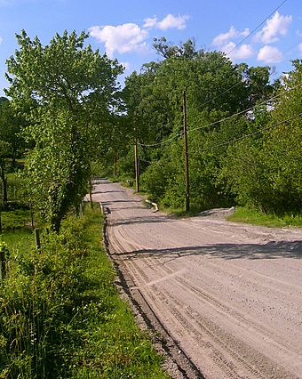
View north along road near Travis Corners, 2008
|
|
| Location | Philipstown, NY |
|---|---|
| Nearest city | Peekskill |
| Area | 6.6 miles (10.6 km) in length |
| Built | 1669-1798 |
| MPS | Hudson Highlands MRA |
| NRHP reference No. | 82003396 |
| Added to NRHP | 1982 |
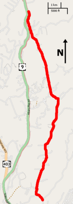
The Old Albany Post Road is a 6.6-mile (10.6 km) dirt road in Philipstown, New York. It is one of the oldest unpaved roads still used in the United States. This historic road runs mostly north-south through the southeastern part of Philipstown. It starts near the Putnam-Westchester county line and ends at US 9 near Garrison.
This section of the original Albany Post Road has changed very little over time. Because of its long history, it was added to the National Register of Historic Places (NRHP) in 1982. The road's story began in the mid-1600s. It was built on old trails used by Native American tribes. Later, it became important for military travel, especially for the Continental Army during the Revolutionary War. It was also a busy route for stagecoaches carrying mail and people.
Some of the old milestones are still there today. These stones were placed to help calculate postal rates more accurately. They have been cared for and restored. The road is still open to the public and is maintained by the town. Recently, there have been discussions about paving the road, which has led to different opinions among local residents.
Contents
Exploring the Old Albany Post Road
The Old Albany Post Road goes through a mostly wooded area with few houses. It is located along the edge of the Hudson Highlands. There are no towns or big developments directly along the road. The land is rugged, meaning the road goes up and down many hills. Some parts offer beautiful views of meadows and nearby mountains.
The road begins where Gallows Hill Road turns into Sprout Brook Road. At first, it winds northwest, getting narrow in some spots. It climbs steadily until it crosses the Catskill Aqueduct. Then, it widens and turns northeast. Over the next two miles (3 km), it goes up and down hills near Lake Celeste, then heads more directly north. It bends northeast again, passing through undeveloped areas, until it reaches Chapman Road. Here, the famous Appalachian Trail crosses the road.
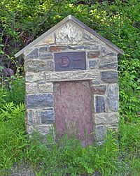
After Chapman Road, the road continues north, going around Fort Defiance Mountain. It then turns northwest at Canopus Hill Road. At the corner of Travis Corners Road, there is a monument that explains the road's historical importance. From here, it runs almost straight north-northwest. It passes some farms and open land before crossing Philipse Brook at Philipse Brook Road.
Further on, the road stays mostly straight and northwest. It goes through more wooded areas along a ridgetop, near the southwestern part of Clarence Fahnestock State Park. Then, it turns west and goes downhill to the intersection with Indian Brook Road. This is near the historic Bird and Bottle Inn. From here, it runs parallel to nearby Route 9, passing through more developed areas, until it finally merges with the highway.
History of the Old Albany Post Road
Most of the work to build and widen the Old Albany Post Road happened during the colonial era. The road has not changed much since the mid-1700s. Later improvements in transportation, like new roads and railroads, meant less traffic used this old route. This helped keep the road in its original historic condition.
Colonial Beginnings (1600s-1700s)
In 1669, the government of New Netherland created a postal route. This route connected what would become New York City and Albany. These were the two most important cities in the colony. At first, it was just a narrow path, following old trails used by the Wiccoppe and Wappinger Native American tribes. These tribes often carried the mail. A long part of this route included the current Old Albany Post Road.
The colony later became the English Province of New York. In 1703, the government declared the postal road a "public and common general highway." It started in Kingsbridge and ended at a ferry landing in what is now Rensselaer. The law allowed the road to be as wide as 66 feet (20 m) where needed. It was first called the Queen's Road, after Queen Anne. Later, it became the King's Road under George I and II.
As the main route between New York City and Albany, businesses like inns started to appear. These inns served travelers. The most famous, John Warren's Tavern, was built in 1756. Today, it is still open as the Bird and Bottle Inn restaurant.
The road was greatly improved when the British Army needed better defenses against the French to the north. In 1754, the road was widened again. Trees were cleared to allow more troops and supplies to pass. Milestones, which are markers showing distances, were first placed around 1763. This happened after Benjamin Franklin, who supported using them, became the colonies' Joint Postmaster General.
After the French and Indian War, the road was used against the British by George Washington's Continental Army. Washington's army used it as a supply route and often traveled on it. The road was surveyed during the war, and the first map was published.
Later Years (1700s-1800s)
After the Revolutionary War, the new state of New York continued to use the road. A regular stagecoach route was started in 1785. The mileposts were updated by the end of the century. By then, mail was regularly carried weekly, going up one side of the river and down the other.
In 1789, a new survey was done, and old maps were updated. These new maps match the milestone locations we see today. Ten years later, a New York law required every county highway superintendent to place stone mile markers along the road. By the next year, all the remaining mileposts were in place.
A private company built the Highlands Turnpike to the west in 1806. This new road was flatter and diverted traffic away from the Old Albany Post Road. The old road became less used for long-distance travel. By 1850, the Hudson River Railroad was completed to Albany. This made the Old Albany Post Road no longer needed for commercial or postal services, and stagecoach service ended.
Modern Times (1900s-Today)
The Old Albany Post Road became important again briefly in the 1910s. This was when the New York City water supply system was expanded. The road provided access to a section of the Catskill Aqueduct during its construction. Shops, housing, and places for workers were built along the road. A decade later, the Highlands Turnpike became the main north-south route and was paved as Route 9.
In 1921, a monument to the "Mothers of the Revolution" was placed at the southern end of the road. Homes and farms along the road got electricity in 1935. This added utility poles to the landscape. A small part of the road near Travis Corners was paved with tar and gravel in the 20th century. Other than that, it remains much as it was in the mid-1700s. After it was listed on the NRHP, a group called the Old Road Society of Philipstown (ORSP) was formed to help protect and promote it.
In recent years, the town has considered paving the road. They say it would be cheaper to maintain and would help with silt and erosion issues in a nearby brook. This idea has caused disagreements among residents. Those against paving say it would ruin the road's historic character and rural charm. Those who support paving, especially near the southern end, worry about public safety. They point to problems like emergency vehicles not being able to pass during heavy storms that cause deep holes in the road. The Federal Emergency Management Agency has given the town money to repair the road, but it's not yet decided if it will be used for paving.
In November 2012, a local newspaper reported that the town budget included plans for paving parts of the historic dirt roads. People against paving argue that the road's historic, beautiful, cultural, and recreational value would be lost. Many residents and experts have shown that better dirt road maintenance could save money and improve water quality, keeping the road's historic nature. They also noted that drivers go slower on dirt roads, which makes them safer for people walking.
Historic Features Along the Road
The entire 66-foot (20 m) right-of-way (the land the road sits on) that was allowed in 1703 is part of the NRHP listing. This means that other features, like the stone walls next to the road and the shade trees, are also considered important historical parts of the road. All the milestones are included, even milestone number 52, which is actually on Gallows Hill Road, a little south of the main road.
Some buildings along the road are also historically important. The Bird and Bottle Inn is a key part of the Indian Brook Road Historic District. This district itself includes a section of the Old Albany Post Road. In the two-mile (3.2 km) section south of the inn, there is a Civil War-era farmhouse and an inn from the 1770s. Both have had some newer parts added. Across from Lake Celeste is Pine Run Farm, which dates back to 1800.
 | Jackie Robinson |
 | Jack Johnson |
 | Althea Gibson |
 | Arthur Ashe |
 | Muhammad Ali |


