
Indian Mesa facts for kids
Quick facts for kids Indian Mesa |
|
|---|---|

Indian Mesa at Lake Pleasant Regional Park in Arizona.
|
|
| Highest point | |
| Geography | |

Indian Mesa
Location in Arizona
|
|
| Country | United States |
| State | Arizona |
| Region | Lake Pleasant Regional Park Agua Fria River |
| County | Maricopa |
| Communities | Peoria |
Indian Mesa is a unique flat-topped hill with steep sides, almost like natural walls. You can find it inside Lake Pleasant Regional Park in Arizona. It sits near the shores of Lake Pleasant and the Agua Fria River, within the Bradshaw Mountain Range. This park is part of Peoria, Arizona.
At the very top of Indian Mesa, there are amazing ruins of an ancient village. This village was built by the Hohokam people long ago. Today, this site is very important for archaeologists. It is protected and watched over by the Arizona Site Stewards and the U.S. Bureau of Land Management. A small, steep, and narrow path leads from the base of the hill all the way to the top.
Contents
Discovering the Hohokam Village on Indian Mesa
Indian Mesa is located in the huge Lake Pleasant Regional Park. This park covers about 10,000 acres (40 square kilometers). Lake Pleasant is a key artificial lake that helps supply water to the Phoenix area. The Agua Fria River fills this lake.
Historians believe that between the years AD 1000 and AD 1200, the ancient Hohokam people built a village here. This community might have been home to 100 to 200 people. The top of the mesa was a perfect spot for a village. Its high, steep cliffs made it easy to defend against any attackers.
Who Were the Hohokam People?
The word "Hohokam" comes from the O'odham people. Archaeologists use it to describe a group of Native Americans. They lived in the Sonoran Desert of North America. Many believe the Hohokam were ancestors of today's Akimel O'odham (Pima) and Tohono O'odham peoples in Southern Arizona. They created a complex society based on farming. They used an amazing system of canals to bring water to their crops.
Hohokam men spent much of their time hunting for food. The women usually cared for the children and managed the homes. Their houses were mainly used for sleeping and storing things. They also offered protection from bad weather. To build their homes, they dug holes in the ground. Then, they placed strong mesquite or pine posts in these holes to hold up the roof.
Among the ruins, you can still see old fire pits. These were used for cooking food and making pottery. The clay for their pottery came from the shores of the Agua Fria River. Making pottery took a lot of time, but the pots were very useful. They used them to hold water. If a pot broke, the pieces were sometimes turned into ornaments. The Hohokam also made beautiful jewelry. They used raw shells that they traded for from northern Mexico.
Why Did the Hohokam Leave?
No one knows for sure why the Hohokam left their village. There was a big drop in the amount of shells they got from Mexico. This also meant less jewelry was made. They also started building different types of homes. They moved from pit-houses (homes dug into the ground) to pit-rooms. These changes might have led to many Hohokam villages being left empty.
Archaeological finds, like those at Indian Mesa, show that the Hohokam didn't just disappear overnight. It's thought that their culture slowly changed over many generations. What remained of their culture was passed down to their descendants. These include the Pima and Tohono O'odham peoples. The ruins on Indian Mesa are some of the best-preserved examples of this ancient community. The U.S. Bureau of Land Management now protects these ruins and the mesa. The Arizona Site Stewards help monitor them.
Hiking to Indian Mesa
You don't need a special permit to hike to Indian Mesa. To get there from Phoenix, Arizona, you drive north on the I-17 highway. Then, you take the Table Mesa Road exit. The hike to the mesa is about 3 miles from where you park your car. The entire round trip is 6 miles. The path is rocky and goes through a mix of desert and semi-desert ecosystems.
The climb to the top of the mesa is about 400 feet high. It's a steep and narrow path. There's even a dangerous hundred-foot drop in one spot, so be careful! It's very important that you do not remove any artifacts from the site. It is strictly against the law.
Protecting Indian Mesa's History
On January 11, 2000, President Bill Clinton declared the area around Indian Mesa a national monument. It is now called the "Agua Fria National Monument." The Bureau of Land Management oversees this special area.
This means the entire area, including all the ancient artifacts, is protected. This protection comes from the Antiquities Act of 1906. This law was passed by the United States Congress and signed by President Theodore Roosevelt on June 8, 1906. It makes it illegal to remove anything from Indian Mesa.
The law states that anyone who damages or takes any historic or prehistoric items from government land without permission can face fines or even jail time. This rule helps keep these important historical sites safe for everyone to learn from.
Gallery
The following pictures show the thousand-year-old Hohokam village ruins on top of Indian Mesa.
- Hohokam village ruins on top of Indian Mesa
-
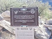
U.S. Bureau of Land Management Marker on Indian Mesa. The marker warns that removal of artifacts is strictly forbidden by Federal Law.
-
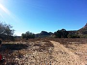
Hiking trail leading to the Indian Mesa (in the background). The hiking trail is located on a portion of a canal which the Hohokam built in 700 AD.. The canal is now filled with soil.
-
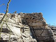
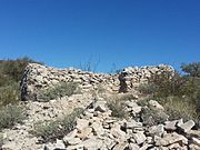
Different views of the ruins of a village built by Hohokam Puebloans about 1000 years ago on top of Indian Mesa. This is part of the wall of the fort that surrounded the village. The holes in the wall are viewing holes so the defenders can view the only path to the top. There are several branches of an "Ocotillo" shrub in the foreground.
-
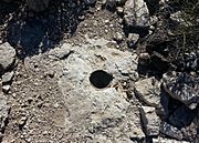
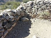
A posthole dug by the Hohokam inside their house. The Hohokam placed heavy mesquite or pine posts on them to support a roof.
-
Different view of the ruins of a Hohokam house.
-
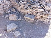
Another view of the ruins of a Hohokam house.
-
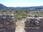
Entrance to a Hohokam home. Lake Pleasant is in the background.
-
Rocky trail leading to the entrance of a Hohokam house.
-
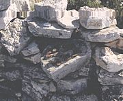
Ancient Hohokam pottery pieces (small brown ones) found at Indian Mesa.


