
Iron County MRA facts for kids
Quick facts for kids |
|
|
Iron County MRA
|
|

Clockwise from top left: Courthouse Residential Historic District, Crystal Falls Dam & Powerplant, Munro – M.A. Hanna Mining Company Office Building, Park City Historic District, Harvey Van Wagner House, Finnish and Swedish Mercantile Association Building
|
|

Location in Michigan

Location in the United States
|
|
| Location | Iron County, Michigan |
|---|---|
| MPS | Iron County MRA |
| NRHP reference No. | 83003659, 660, 662, 664, 665, 667, 671-676, 678, 680-682, 687, 689, 691, 692, 694, 696, 698, 699, 701, 703, 705, 707, 709, 711, 713, 714, 716-731, 734, 736, 737, 739, 740, 742-744, 746, 748-752, 759, 761, 762, 764, and 766-770; 93001408 |
| Added to NRHP | December 22 and 29, 1983; August 3, 1994 |
The Iron County MRA is a special list of important places in Iron County, Michigan. It includes 72 different buildings and neighborhoods. These places are recognized on the National Register of Historic Places because they are historically significant. Most of them were added to the list in 1983, with one more added in 1993.
Contents
- History of Iron County
- Iron County Geography
- Finding Historic Places
- Crystal Falls Historic Sites
- Courthouse Residential Historic District
- Crystal Falls Dam and Power Plant
- Crystal Inn
- Ernest Diele House
- Falls Location Historic District
- Finnish and Swedish Mercantile Association Building
- John Hasselstrom House
- Frank C. Huse House
- Timothy Murphy House (Harbour House)
- John H. Parks Company – Wills Hardware Building
- Herman Rau House
- David M. Ross House
- Steven Royce House
- William Russell House
- John Soderman Farmhouse
- Iron River Historic Sites
- Isaac W. Byers House
- Rudolf Ericson House
- Nelson E. Fisher House – High Banks
- Henry H. Frailing House
- Dennis J. Haggerty House
- Iron County Fair Exhibition Hall
- Iron River Creamery
- Iron River Town Hall
- Joseph Joseph House
- Alexander MacKinnon House
- William Moss House
- Munro – M.A. Hanna Mining Company Office Building
- St. Mary's Assumption Catholic Church
- Scalcucci's Grocery
- Robert H. Sturgeon House
- William J. Tully House
- Van Ornum's Addition Historic District
- Harvey Van Wagner House
- Wall-Seppanen House
- Joseph Windsor House
- Stambaugh Historic Sites
- Mineral Hills Historic Sites
- Caspian Historic Sites
- Alpha Historic Sites
- Amasa Historic Sites
- Beechwood Historic Sites
- Other Historic Locations
- Images for kids
History of Iron County
Iron County was first explored in 1851. At that time, mostly Native Americans lived there. They were from the Menominee and Ojibwe tribes.
Even though iron ore was found in 1851, European settlers didn't arrive in large numbers until 1875. They came looking for iron ore. In 1880, two big discoveries were made. John Armstrong opened the Crystal Falls Mine. Donald C. MacKinnon opened the Iron River Mine.
These two mines helped create the main towns in the county. Many more people came, and eventually 70 mines were digging for ore.
Early Industries and Growth
Logging also started in 1875. Lumber mills soon became important for the economy. Railroads, like the Chicago and Northwestern Railroad, built lines to serve the growing mines. Lines to both Iron River and Crystal Falls were finished in 1882. Both towns grew very quickly.
In 1882, separate townships were created for Iron River and Crystal Falls. These were still part of Marquette County. But many people wanted their own county. So, in 1885, Iron County was created from Marquette County.
When Iron County was formed, Iron River was chosen as the county seat. This meant it was where the county government offices would be. However, there was a big argument about where the county buildings should be. The east side, around Crystal Falls, and the west side, around Iron River, both wanted the buildings. The argument lasted until 1889. Then, a county-wide election chose Crystal Falls as the county seat.
By 1890, almost 4,500 people lived in Iron County. Most of them worked in mining and timber. But in 1893, a financial crisis called the Panic of 1893 caused iron prices to drop. Almost all the iron mines closed. Lumbering also slowed down a lot. People in the county started farming to support themselves.
Rebound and the Great Depression
The economy got better around 1900. Big mining companies like the M. A. Hanna Company bought smaller mines. Logging of hardwood trees also began. This led to a long period of growth until the Great Depression.
The county's population grew a lot during this time. It reached over 20,805 people by 1930. Many new people were immigrants from places like Ireland, Italy, Poland, and Scandinavia. New villages were planned to house mine workers. These included Alpha, Mineral Hills, Caspian, and Gaastra. Iron River, Crystal Falls, and Stambaugh also expanded. To help the new residents, an electric street car line was built in 1906. Many public schools were also constructed.
The Great Depression stopped Iron County's economic boom. Iron mining completely stopped. Lumbering was greatly reduced, leaving thousands of workers without jobs. The government started some projects to help. These included the Cooks Run Trout Feeding Station (1933-34) and the Pentoga Park Office and Bathhouse (1936). Workers from the Civilian Conservation Corps also built projects at Camp Gibbs (1934).
Mining briefly came back during World War II. But after the war, mining slowly declined. Few mines lasted into the 1960s. The last iron mine in the county closed in 1979. However, lumbering is still a big business in the area today.
Iron County Geography
Iron County covers about 1,211 square miles. Most of this is land (1,166 square miles), and 45 square miles is water. The land is generally hilly. It has many small hills called moraines and small lakes. These are on top of the iron ore deposits.
There are eight main towns in Iron County. Five are on the west side and three on the east. The west-side towns are Iron River, Stambaugh, Caspian, Gaastra, and Mineral Hills. These towns are close together along the Iron River. In 2000, Stambaugh and Mineral Hills became part of Iron River.
The east-side towns are Crystal Falls, which is the county seat. Alpha is six miles away. Amasa is sixteen miles away. Most of these towns are along US Highway 2. The rest of the county is mostly forest. The western part is part of the Ottawa National Forest.
Finding Historic Places
In the 1970s, people started looking for historic places in Iron County. They did surveys and made lists. For example, there was a list of historic sites in Michigan's Upper Peninsula. There was also a survey of old engineering and industrial sites. The Iron County Historical and Museum Society also made a big list.
In 1977, the Iron County Courthouse was added to the National Register of Historic Places. This was the first place in the county to get this special recognition. After that, other buildings in the county were listed on the Michigan State Register of Historic Sites.
Later in 1977, the Iron County government and the Historical Society worked together. They wanted to nominate a "Multiple Resource Area" to the National Register. This meant listing many historic places together. They used the old surveys and looked at the sites in 1979-80. They did historical research for two years. The list was finalized in 1982-83.
Crystal Falls Historic Sites
Crystal Falls began as a settlement in 1880. Two mines, the Paint River Mine and the Crystal Falls Mine, opened there. A sawmill also started right away. By 1881, so much iron ore was found that the Chicago and Northwestern Railroad extended its line to Crystal Falls.
The railroad was finished in 1882. Crystal Falls grew very fast. It went from four businesses in 1882 to twenty-five by 1884. Schools were built in 1882. Crystal Falls became a village in 1889, the same year it became the county seat. By 1890, the population was 3,231. In 1891, the village built its own hydroelectric plant. Crystal Falls became a city in 1899. It kept growing with new streetlights, sewers, and government buildings. This growth stopped with the Great Depression.
There are seventeen buildings and districts from Crystal Falls on this historic list. The Iron County Courthouse is also historic but was listed separately.
Courthouse Residential Historic District

46°05′46″N 88°20′12″W / 46.096111°N 88.336667°W
This district is a neighborhood with many beautiful old homes. It's located near the Iron County Courthouse. Most of these homes were built when mining and lumbering were booming. Important people like mining officials and businessmen lived here. The houses show different styles, like Queen Anne and Colonial Revival. The district also includes a Gothic Revival church, three school buildings, and the old sheriff's residence and jail.
Crystal Falls Dam and Power Plant

46°06′22″N 88°20′05″W / 46.106111°N 88.334722°W
This power plant is on the Paint River. The river used to have waterfalls and rapids, which gave Crystal Falls its name. In 1891, the village built the dam and power plant, covering the rapids. A new power plant was built in 1902-1903. It was expanded several times. The plant is still working today. It's probably the oldest hydro-electric plant still running in the Upper Peninsula. It provides about one-third of Crystal Falls' power.
The power plant is a two-story building made of yellow brick with sandstone trim. The dam is about 75 feet long and 15 feet high.
Crystal Inn

46°05′49″N 88°19′59″W / 46.096944°N 88.333056°W
The Crystal Inn is a large building that used to be a hotel. It's also known as Crystal Manor or Crystal View Apartments. The first hotel on this spot burned down in 1918. The current building was finished in 1922. It was a hotel until 1963, then it became a home for older people. It closed in 1998. In 2010, it was renovated into 25 apartments.
The Crystal Inn is a three-story building. It's made of two-colored brick with sandstone details. It has a U-shape and a classic look. The first floor has an arcade-like entrance with columns.
Ernest Diele House

46°05′44″N 88°19′50″W / 46.095556°N 88.330556°W
The Ernest Diele House is a two-story house. It was built around 1910 for Ernest Diele. He was the main mason for the Corrigan-McInney Mining Company. It's a simple but sturdy house, typical for managers and skilled workers in the mining industry. It has a hipped roof and a glassed-in front porch.
Falls Location Historic District

46°06′27″N 88°20′20″W / 46.1075°N 88.338889°W
This district has seven log houses and other small buildings. It's located near the Paint River. The settlement grew between 1880 and 1900, likely because of the nearby Crystal Falls Mine. All the houses are made of logs. Some have been made bigger or covered with modern siding. This district is important because it's one of only three log dwelling settlements left in Iron County.
Finnish and Swedish Mercantile Association Building

46°05′49″N 88°19′56″W / 46.096944°N 88.332222°W
This building was built in 1908. It was for a grocery and department store owned by local Finns and Swedes. It reminds us of the large Scandinavian population in Crystal Falls in the early 1900s. The first floor still has a grocery store, and there are offices upstairs. The building is made of brick with a classical metal cornice.
John Hasselstrom House

46°05′52″N 88°19′58″W / 46.097778°N 88.332778°W
The John Hasselstrom House is a 1½-story house. It was built in 1898 by John Hasselstrom, a local carpenter. It has a unique Queen Anne style. It features a prominent octagonal tower with a steep roof and a large wraparound porch.
Frank C. Huse House

46°05′31″N 88°20′03″W / 46.091944°N 88.334167°W
This 1½-story house was likely built for Frank C. Huse. He was the local agent for the Chicago and Northwestern Railroad. The house looks a bit like a small train station. It has special siding and decorative boards on the gables.
Timothy Murphy House (Harbour House)

46°05′51″N 88°19′57″W / 46.0975°N 88.3325°W
The Timothy Murphy House is made of concrete blocks. It was built around 1900. It was later bought by the Crystal Falls Museum Society in 1982. After being restored, it now serves as a hands-on museum.
The house is a large two-story building with a hipped roof. It's symmetrical, with matching towers on each corner. A two-story wooden porch wraps around the front, giving it a unique look.
John H. Parks Company – Wills Hardware Building


46°05′48″N 88°19′54″W / 46.096667°N 88.331667°W
This commercial building was built around 1890 for the John H. Parks Company Department Store. John H. Parks was an important lumberman and the first mayor of Crystal Falls. Later, it became a hardware store. It's important because it's one of the best-preserved commercial buildings from the late 1800s in Crystal Falls. It's a two-story building with clapboard siding and bay windows.
Herman Rau House

46°05′44″N 88°19′55″W / 46.095556°N 88.331944°W
The Herman Rau House is a 1½-story house. It was built around 1890 for Herman Rau, who owned a local grocery and meat market. The house is known for its well-preserved Late Victorian details. It has an L-shape with a gable roof and wide eaves.
David M. Ross House

46°05′42″N 88°19′58″W / 46.095°N 88.332778°W
This stone house was built for David M. Ross, a grocery store owner. It's a great example of the bungalow style in Iron County. The first floor is made of cobblestones, and the second floor has stucco with decorative wood.
Steven Royce House

46°05′49″N 88°20′30″W / 46.096944°N 88.341667°W
The Steven Royce House was built by the Corrigan, McKinney & Company mining firm. It was a home for their professional staff. Steven Royce, a geologist, was an early resident. It's a two-story Colonial Revival house with clapboard siding and full-width porches.
William Russell House

46°05′40″N 88°19′48″W / 46.094444°N 88.33°W
The William Russell House was built in 1888 for William Russell, an early Crystal Falls businessman. He owned a saloon and was a contractor. This house is one of the best Queen Anne style homes in Iron County. It has two stories, wooden shingles, and stained glass windows.
John Soderman Farmhouse

46°06′16″N 88°20′12″W / 46.104444°N 88.336667°W
This farmhouse belonged to John Soderman, a successful dairy and potato farmer. He was one of the few full-time farmers in Iron County. The farm is still owned by the Soderman family. The house is a two-story gabled building with clapboard siding.
Iron River Historic Sites
In 1880, R. L. Selden and his son started looking for iron ore along the Maple River. They found enough to open the Iron River Mine. William Selden convinced the Chicago and Northwestern Railroad to build a line to the area. At the same time, Donald C. and Alexander MacKinnon planned a village on the west bank of the river, which became Iron River.
The railroad line to Iron River was finished in 1882. Many settlers quickly moved to the area. The MacKinnon brothers built a sawmill. Houses, stores, a hotel, and churches were built. Iron River became a village in 1885, with over 1,000 people. However, the Panic of 1893 hurt the local iron industry. No ore was mined on the west side of Iron County from 1889 to 1900. Logging and farming became the main activities.
After 1900, iron mining became important again in Iron River. Ten new mines opened between 1905 and 1912. More people moved to Iron River. The village installed sewer and electric systems. In 1913, a street railway connected Iron River to nearby mining towns. Iron River became a city in 1926. Like the rest of Iron County, it suffered during the Great Depression. Mining briefly increased during and after World War II. In 2000, Iron River merged with Stambaugh and Mineral Hills.
The city still has many buildings from its boom times (1900–1920). There are 24 buildings and districts from old Iron River on this list. Two other structures, the Chicago, Milwaukee and Saint Paul Railway Iron River Depot and Central School, are also historic but were listed separately.
Isaac W. Byers House

46°05′16″N 88°38′50″W / 46.087778°N 88.647222°W
This 1½-story house was built around 1919 for Isaac W. Byers. He was a lawyer and a key developer in the Iron River area. Byers helped start the Iron Savings and Loan Association and financed much of the development in Stambaugh, Iron River, and Caspian. He also held many important public offices. The house is built in the Queen Anne style.
Rudolf Ericson House

46°05′24″N 88°38′47″W / 46.09°N 88.646389°W
The Rudolf Ericson House is a small, 1½-story house built in 1937. It was for Rudolf Ericson, the general superintendent of the Davidson Ore Mining Company. Ericson was a respected underground engineer. He also helped organize the village of Mineral Hills and was its first president. The house has a unique "English cottage style" with glazed brick and a faux thatch roof.
Nelson E. Fisher House – High Banks

46°05′51″N 88°40′29″W / 46.0975°N 88.674722°W
This house was built in 1912 for Nelson A. Fisher, an important Iron River businessman. Fisher was part of a group called the "Big Five" who developed the area. His daughter, Aileen Fisher, later became a famous children's author. Her childhood memories of this house, called "High Banks," influenced her writing. The house is a two-story Colonial Revival style.
Henry H. Frailing House

46°05′36″N 88°38′18″W / 46.093333°N 88.638333°W
The Henry H. Frailing House is an Italianate style house built around 1916. It was for Henry H. Frailing, who owned the Iron River Creamery. It's one of the few buildings in Iron County with Italian architectural influences. It's a symmetrical brick house with sandstone details.
Dennis J. Haggerty House

46°05′16″N 88°38′44″W / 46.087778°N 88.645556°W
This brick bungalow-style house was built in 1926 for Dennis J. Haggerty. He was a skilled worker who worked for many local mines. Haggerty worked as a surveyor, then in the mechanical department for various mines until he retired. The house has a brick front porch and a stuccoed dormer.
Iron County Fair Exhibition Hall

46°06′02″N 88°38′47″W / 46.100556°N 88.646389°W
This concrete block building was built in 1931 for the Iron County Fair. The fair started in 1899. The building has a central, two-story octagonal section with wings. It might be the last of its kind in Michigan. The octagonal part has a low roof and round-arched main entrance.
Iron River Creamery

46°05′36″N 88°38′17″W / 46.093333°N 88.638056°W
The Iron River Creamery is a brick industrial building. It was founded in 1913 by Henry H. Frailing. He built this larger building in 1920. It was later sold and is now used by an electric company. The creamery is a good example of Classical Revival commercial architecture. It's a two-story brick building with large brick columns.
Iron River Town Hall

46°05′31″N 88°38′21″W / 46.091944°N 88.639167°W
The Iron River Town Hall (now City Hall) was built in 1915. It was designed by architect Samuel C. Allen. The building was updated in 1964, but its interior has stayed mostly the same. It's a three-story Neo-Classical building made of red brick. It still shows Iron River's prosperity in the early 1900s.
Joseph Joseph House

46°05′24″N 88°38′50″W / 46.09°N 88.647222°W
The Joseph Joseph House is a stucco house built in 1925. It was first lived in by Joseph Joseph, an early Jewish settler. He opened a clothing shop in Iron River in 1914. This house is a unique example of Spanish-style architecture in the county. It's a single-story building with white stucco and a red tile roof.
Alexander MacKinnon House

46°05′37″N 88°38′23″W / 46.093611°N 88.639722°W
This two-story house was built around 1900 for Alexander MacKinnon. He and his brother Donald were pioneers in finding iron ore in the Iron River Valley. They planned the village of Iron River in 1881. The house has multiple gables and two porches with decorative woodwork.
William Moss House

46°05′31″N 88°38′40″W / 46.091944°N 88.644444°W
The William Moss House is a two-story duplex built around 1908. It's unusual for Iron County because it's a middle-class duplex with different floor plans on each level. The original owner, William Moss, likely lived on the first floor and rented out the second. It has a hipped roof and an Ionic front porch.
Munro – M.A. Hanna Mining Company Office Building

46°05′21″N 88°38′35″W / 46.089167°N 88.643056°W
This office building was built around 1920 by the Munro Mining Company. In 1929, it was bought by the M. A. Hanna Company. They used it as their local headquarters until 1969. It later housed a community agency. It's a large, symmetrical, two-story Classical Revival brick building.
St. Mary's Assumption Catholic Church

46°05′22″N 88°38′41″W / 46.089444°N 88.644722°W
This church was built for Polish Catholic families. The main part was built in 1920-22. It's a Gothic Revival style church with a square bell tower and a spire. The church is made of red brick with sandstone trim. The parish closed in 1981-82, and the building is now used by another church.
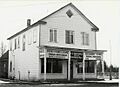
Scalcucci's Grocery

46°06′30″N 88°38′14″W / 46.108333°N 88.637222°W
Scalcucci's Grocery was built in 1905. John Scalcucci bought it in 1914. He ran a grocery store on the first floor and lived upstairs. This grocery is famous for an event in 1920 called the "Rum Rebellion." During a time when making certain drinks was restricted, the Scalcucci family continued to make homemade fruit juice. Local police tried to seize their barrels, but they didn't have a warrant. This led to a big disagreement with state officials, but no arrests were made.
The building is a two-story frame structure. The outside has been changed, but the inside, including the basement where the fruit juice was made, is still mostly original.
Robert H. Sturgeon House

46°05′38″N 88°38′20″W / 46.093889°N 88.638889°W
This house was built around 1900. It was the home of Dr. Robert H. Sturgeon, Iron River's first doctor. He worked for mining companies, had his own practice, and helped start the first hospital in Iron River. He also owned businesses and served as the town's assessor and treasurer.
The Sturgeon house is a 2½-story Queen Anne style home with a round tower. It has a large wraparound porch with columns. Inside, it has colored glass windows and original woodwork.
William J. Tully House
46°05′37″N 88°38′39″W / 46.093611°N 88.644167°W
The William J. Tully House is an American Foursquare style home built in 1909. It was the last home of William J. Tully, an early Iron River resident and mine owner. Tully served as county supervisor and sheriff. After that, he started looking for iron ore and owned parts of several mines. The house is square with wide eaves and a partially enclosed front porch.
Van Ornum's Addition Historic District
46°05′52″N 88°38′32″W / 46.097778°N 88.642222°W
This district includes houses on one block of Fourth Street. It has four bungalows built by Edward J. Van Ornum, a well-known builder and developer. It also includes Van Ornum's own home. He built his American Foursquare home around 1910. In 1929, he planned this addition, and in 1934, he built the four bungalows.
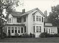
Harvey Van Wagner House

46°05′21″N 88°38′45″W / 46.089167°N 88.645833°W
This house was built around 1920. It's a slightly changed version of a design from a 1918 house-plan book. It has alternating narrow and wide rows of shingles. It was the home of Harvey Van Wagner, who was the vice-president of Old Commercial Bank.
Wall-Seppanen House


46°05′17″N 88°38′45″W / 46.088056°N 88.645833°W
This stone house was built around 1920. It's a very nice bungalow design with Craftsman elements. It's covered with stucco and cobblestones. It was once the home of James S. Wall, who managed the Oliver Iron Mining Company. Later, Wayne E. Seppanen, who became superintendent of the Caspian Mine, bought the house.
Joseph Windsor House

46°05′30″N 88°38′44″W / 46.091667°N 88.645556°W
The Joseph Windsor House is a brick house built around 1912. It was for Joseph Windsor, who ran a furniture and undertaking business with his brother. The house has brick on the first floor and stucco on the second. It has a hipped roof with wide eaves and a front porch with columns.
Stambaugh Historic Sites
In 1882, R. L. Selden and his son, along with others, planned a village next to the Iron River Mine. They named it "Stambaugh" after John Stambaugh, the president of a company that bought the mine. The mining company built houses for its supervisors. In 1890, Stambaugh became a village.
Growth slowed down in the late 1800s because of the Panic of 1893. But it picked up again after 1900. Electricity came in 1908, and a town hall was built in 1913. Because it was so close to Iron River, Stambaugh mostly remained a residential community. In 1923, Stambaugh became a city. Even though it suffered during the Great Depression, it had valuable mining properties that helped it stay financially stable. In 2000, Stambaugh merged with Iron River.
There are twelve buildings and districts from what was once Stambaugh on this historic list.
George Hamilton House

46°05′03″N 88°38′35″W / 46.084167°N 88.643056°W
This bungalow-style house was built in 1914. It was the home of George Hamilton, who was once the city engineer and president of the Stambaugh village council. The house is a 1½-story bungalow with a gable roof. Its walls are covered with stucco and shingles. It's one of the best-preserved bungalows in Stambaugh.
M. A. Hanna Company Michigan District Superintendent's House

46°05′03″N 88°38′36″W / 46.084167°N 88.643333°W
This two-story house was built in 1933 by M.A. Hanna. It was for the chief executive of the company's local mines. M.A. Hanna bought existing mines in the late 1920s. The house is a two-story Colonial Revival style building with a symmetrical front.
John W. Hanson House

46°04′58″N 88°37′33″W / 46.082778°N 88.625833°W
The John W. Hanson House is a 1½-story frame bungalow built around 1920. It was for John W. Hanson. The house has clapboard siding on the first floor and wooden shingles on the second. It has a fieldstone foundation and a gently sloped gable roof. It's unique in the county for its stylized Federal details, like Palladian windows.
Joseph Harris House

46°04′56″N 88°37′55″W / 46.082222°N 88.631944°W
This two-story Prairie-style house was first owned by Joseph Harris. He owned the Harris Clothing Store in Iron River. This house is the best example of Prairie style in the county. It has a hipped roof, attic dormers, and a large arched front porch. It features stucco walls and leaded glass windows.
Hiawatha Mine Number One Complex

46°04′33″N 88°38′38″W / 46.075833°N 88.643889°W
This complex has five buildings on four acres. Iron ore was first mined here in 1893. The Hiawatha became one of the most productive mines in the county, operating until 1950. The mine shaft went down 2,100 feet, making it the deepest mine in the county. This site is probably the best-preserved mine operation site in Iron County.
The most noticeable building is the 120-foot tall steel Hiawatha Mine Number One headframe, built in 1904. It's the oldest surviving headframe in Michigan. The complex also includes four single-story buildings.
Nels A. Holmes Farmstead


46°03′01″N 88°38′38″W / 46.050278°N 88.643889°W
This farmstead includes several buildings. In 1884, Nelson Holmes, an immigrant from Sweden, settled on this land. The farm has been in the Holmes and Sackerson family for over 100 years. The farmhouse is a 1½-story timber-framed house built in 1890 around an older log cabin. It has clapboard siding and a fieldstone foundation. Other buildings include a wellshed, chicken coop, and summer kitchen.
House at 902 Selden Road

46°04′49″N 88°38′36″W / 46.080278°N 88.643333°W
This 1½-story house was built for the Youngstown Mines Corporation. It was likely for the families of administrative or supervisory employees. It has clapboard siding and Queen Anne style shingles on the gable. It's important for its good architectural quality and how well it has been preserved.
Louis Levine House

46°05′04″N 88°38′35″W / 46.084444°N 88.643056°W
The Louis Levine House is a two-story frame house built around 1922–25. Louis Levine was one of its early owners. It's a distinct Colonial style house with a veranda, clapboard and shingle siding, and a cobblestone foundation.
Lafayette McQuown House

46°05′05″N 88°37′52″W / 46.084722°N 88.631111°W
This simple frame house was built around 1895 for Lafayette McQuown. He was an early resident of Stambaugh and helped survey the town site. He worked for the Oliver Mining Company for many years. He likely used this house as a rental property. It's a typical example of a late 19th-century miner's home and is well-preserved.
Charles Stolberg House
46°05′08″N 88°37′49″W / 46.085556°N 88.630278°W
This two-story frame house was built in 1909 for Charles Stolberg. He was one of Stambaugh's first residents and worked in local mines for 48 years. The Stolberg family lived here from 1909 to 1915. It's one of the best-preserved Queen Anne structures in Stambaugh. It has patterned shingles, stained glass windows, and a wraparound porch.
John Swanson House
46°05′03″N 88°37′54″W / 46.084167°N 88.631667°W
The John Swanson House is a two-story frame house built in 1913. It was for John Swanson, who started the Consolidated Mercantile Store. The house is an American Foursquare style with a full-length front porch and an attic dormer. It has clapboard siding on the first floor and wood shingles on the second.
Mineral Hills Historic Sites
In 1905, William James found iron ore in the hills north of Iron River. He opened a mine, and in 1906, the Mineral Hills Mining Company bought it. They built 12 frame houses nearby. Over the next 10 years, five more mines opened, each building houses. In 1919, all six mine locations became the village of Mineral Hills. A village hall was built in 1921. Because it was so close to Iron River, Mineral Hills never developed many businesses. In 2000, Mineral Hills merged with Iron River.
There is one historic district and one standalone building from what was once Mineral Hills on this list.
James Mine Historic District

46°06′50″N 88°38′33″W / 46.113889°N 88.6425°W
This district has several buildings. The James Mine operated from 1906 until 1950. It reached a depth of 860 feet. The buildings in the district were built between 1906 and 1921 by the Mineral Hills Mining Company for its miners and officials. They include a dry house, pump house, blacksmith shop, and engine house. The district also includes the surrounding homes. It's important as a well-preserved example of a mining company settlement.
Spies Boardinghouse
46°06′34″N 88°37′55″W / 46.109444°N 88.631944°W
The Spies Boardinghouse is a two-story residential building. It was built in 1909 by James Johnson for the Cleveland Cliffs Iron Company. It housed unmarried miners in ten bedrooms on the second floor. The first floor had a dining room, kitchen, and living quarters for the manager. In the early 1930s, it was converted into four apartments.
Caspian Historic Sites
After the Panic of 1893, people started looking for iron ore again near Iron River. Southeast of Iron River, five mines opened in the early 1900s. A small village called "Palatka" was planned in 1901. Mining companies built houses for their workers starting in 1904. A small business area grew to serve the miners. A settlement called "Caspian" was planned in 1908. Eventually, these small settlements merged and became known as "Caspian."
By 1917, almost 2,000 people lived in Caspian. In 1918, it became a village. Water and sewage systems were installed, and a village hall was built in 1923. Many Italian immigrants settled in Caspian, along with people from other countries like Finland and Poland.
Caspian's most prosperous time was the first three decades of the 1900s. It became a city in 1949, after a mining boom during World War II. But it declined when the mines closed. Today, it's a quiet community linked to Iron River.
There are four buildings from Caspian on this historic list.
Caspian Community Center

46°03′43″N 88°37′39″W / 46.061944°N 88.6275°W
This educational facility was built in 1921 in the Arts and Crafts style. It was used by the Presbyterian Board of National Missions to help immigrant families until 1950. It was later bought by the Caspian Athletic Association. It's still used as a community center today, offering play areas and meeting rooms for youth groups. The building is a large two-story structure with stucco and half-timbering.
Caspian Mine Headframe


46°04′04″N 88°37′31″W / 46.067778°N 88.625278°W
The Caspian Mine opened in 1903. The original headframe was made of wood. The current steel structure was built in 1920. A headframe is a tall structure over a mine shaft used to raise and lower miners and ore. This headframe is 106 feet high and covered in corrugated steel.
This headframe is important because it's the oldest one still standing in Iron County. The Caspian Mine was the most productive mine in the county until it closed in 1937. The company that operated the mine later gave the headframe and surrounding land to the Iron County Historical and Museum Society. The area is now the Iron County Historical Museum.
Dober Mining Company House

46°04′22″N 88°37′46″W / 46.072778°N 88.629444°W
This four-family house is one of two remaining houses built around 1910. They were built to house the families of the Dober Mining Company's miners. It's a two-story building with a gable roof and clapboard siding. It's divided into four side-by-side units.
Italian Society Duke of Abruzzi Hall

46°03′41″N 88°37′17″W / 46.061389°N 88.621389°W
The Duca Degli Abruzzi Italian Society was formed in 1909 by Italian men in Caspian. They built the Duke of Abruzzi Hall in 1914 as a meeting place. The building was updated in 1929. This hall helps promote local awareness of the area's Italian heritage. It's also a social gathering spot. The building has a dance hall with its original tin ceiling. There's also a room for making wine and seasoning sausage, and a bocce court next to the building.
Alpha Historic Sites
Mining began near Alpha in 1882. Several mines opened, and a small community called Mastodon grew. However, these mines closed after the Panic of 1893. In 1910, the Pickands-Mather Company started exploring the area again. A settlement was planned near their operations. In 1913 and 1915, two productive mines, the Judson and the Balkan, opened. Many miners came to the area.
The settlement was unusually well-planned for a mining town. It had a central circle with streets radiating from it. The settlement grew quickly. In 1913, a post office opened and was named "Alpha." Alpha became a village the next year. A school, water tower, and village hall were quickly built. Businesses also moved into the new village.
However, the local mines closed in the early 1930s. The village quickly declined. Alpha is now mostly a residential community. It relies on nearby Crystal Falls for goods and services.
There is one historic district and one standalone building from Alpha on this list.
Alpha Public Buildings Historic Complex


46°02′47″N 88°22′40″W / 46.046389°N 88.377778°W
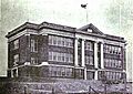
This complex includes three important buildings: the village hall, the George F. Porter public school, and the water tower. They are all located on one block in the center of Alpha. These buildings were all built in 1914 during Alpha's growth. They are typical of public buildings from that time in the Upper Peninsula. The Porter School was last used in 1967 and is now a small business site. The original water tower has been replaced.
The village hall is a single-story building with a gable roof. The George F. Porter School is a two-story Classical Revival building made of brick. It has two entrances with columns.
First National Bank Building

46°02′45″N 88°22′35″W / 46.045833°N 88.376389°W
This commercial building was built in 1914. It's a single-story, square-shaped building made of glazed brick. It has an angled corner entrance. Brick columns flank the entrance and meet a metal cornice.
Amasa Historic Sites
Iron ore was first found along the Hemlock River in 1888. In 1889, the Hemlock Mining Company bought property near what is now Amasa. A railroad line was built, and mining began in 1890. A settlement grew near the mine. It was first called "Hemlock," but in 1892, the name was changed to "Amasa." It was named after Amasa Stone Mather, the son of the mining company's president.
Five more mines opened in the area in the next few years. Lumbering also began. As a result, Amasa grew quickly. In the early 1890s, a township hall, post office, boarding house, train station, and several businesses were built. A fire department, water system, and street lighting were added after 1900. Amasa continued to grow until the 1930s, when local mines started closing. The last mine closed in 1940. Amasa has changed little since then, supported mainly by the timber industry.
There are four buildings and historic districts from Amasa on this list.
Amasa Historic Business District

46°13′58″N 88°26′54″W / 46.232778°N 88.448333°W
This district is located along Pine Street. It has buildings mostly built between 1890 and 1920. These buildings are important because they are well-preserved examples of historic and architecturally significant structures in a mining and lumbering town. The district includes the township hall, a railroad station, a church, bars, a senior citizen's center, a lumber company office, and homes.
The oldest buildings are the Blomquist Boarding House (1892), a hotel (around 1892), and the Amasa Depot (1893). The Grace United Methodist Church (1905) is a simple Gothic frame church. Most of the commercial buildings are long, narrow, two-story frame buildings. Growth in Amasa stopped after the mines closed, so the district looks much like it did in the early 1900s.
More images of the Amasa
|
|---|


Joseph Bowers House

46°14′05″N 88°26′57″W / 46.234722°N 88.449167°W
The Joseph Bowers House is a 1½-story frame house. It was built in 1901. It's covered with clapboard siding and has a gable roof. A wide front porch has turned columns and decorative brackets. This house is a good example of typical miner's housing from that time.
Jacob Jacobson House

46°14′07″N 88°26′56″W / 46.235278°N 88.448889°W
This frame house was built by carpenter Jacob Jacobson in 1902 as his own home. It's a 1½-story rectangular frame building with a gable roof and clapboard siding. A porch with squared and turned columns runs the full length of the house. It's a very well-preserved example of homes from Amasa's early years.
Park City Historic District

46°13′53″N 88°26′17″W / 46.231389°N 88.438056°W
This district is a settlement with seven log houses and other small buildings. The houses were built by iron miners who worked in the nearby Michigan Mine (1891-1916). This district is one of three log cabin settlements left in Iron County. It's important because it was developed by the miners themselves, not by a mining company. The houses are one or 1½-story log buildings.
Beechwood Historic Sites
Beechwood was first settled in 1882. The railroad came through in 1887. In 1891, the community got a post office. The Beechwood Store was built in 1912 and served as the post office until 1976.
There is one historic property located in Beechwood on this list.
Bethany Lutheran Church

46°09′34″N 88°45′42″W / 46.159444°N 88.761667°W
Bethany Lutheran Church is a small church built in 1912–13. It's important because it's a completely unchanged rural church from the early 1900s. It was organized in 1911 for the Swedish Lutheran people of Beechwood. Volunteers from the church built most of it. The church is still used regularly for services.
The church is a rectangular frame building with a gable roof. It's covered with clapboard siding and sits on a rock foundation. It has a hexagonal back section and a square bell tower in the front.
Other Historic Locations
There are five historic districts in rural parts of Iron County on this list.
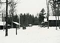
Camp Gibbs

46°12′04″N 88°42′19″W / 46.201111°N 88.705278°W
Camp Gibbs is a camp located in the Ottawa National Forest. It was built by the Civilian Conservation Corps (CCC) in 1935. The CCC was a program during the Great Depression that put young men to work on conservation projects. Camp Gibbs is the only remaining CCC camp in Michigan. It was used from 1935 to 1941 to house workers in the forest. In 1967, the Iron County Sportsman Club bought the camp. It is now the Camp Gibbs Recreation Area.
Camp Gibbs has 16 single-story wooden buildings. Many were originally barracks, but there's also a kitchen, shower room, bakery, and garages. The buildings show simple architecture from a time when saving money was very important.
Cooks Run Trout Feeding Station


46°09′18″N 88°53′32″W / 46.155°N 88.892222°W
This is a small trout hatchery with a pond, dam, and buildings. It was built in 1933-34 by the Civil Works Administration. It helped the Michigan Conservation Department manage local fish populations. The station is now run by the Iron County Park Service.
The most important building is the caretaker's cabin. It's a great example of rustic wilderness camp architecture. It's a 1½-story building made of round logs on a fieldstone foundation. The inside has four rooms with stone chimneys and detailed decorations, including hand-carved light fixtures.
Mansfield Mine Location Historic District

46°07′07″N 88°13′10″W / 46.118611°N 88.219444°W
This district has a collection of log buildings. Mining started here in 1882. The Mansfield Mine opened in 1889. On September 28, 1893, a terrible accident happened. The mine collapsed, and water from the Michigamme River flooded it. Twenty-seven miners drowned. This was the worst mining accident in Iron County's history. The mine closed after the accident. In 1894, a forest fire destroyed most of the original buildings. The mine reopened in 1896 and operated until 1913.
The district includes mostly homes built between 1896 and 1900. Most are small, single-story log houses. One mine-related building, the stone powder house, is still there.
Triangle Ranch Headquarters Historic District

46°18′54″N 88°25′13″W / 46.315°N 88.420278°W
This is a ranch complex started in 1920 by Judson G. Rosebush. He wanted to try large-scale farming methods by raising pedigreed Herefords (a type of cattle). Rosebush bought a lot of land and built big barns. However, the short growing season made it hard to grow enough food for the animals in winter. The ranch tried other things like fur farming and raising sheep, but it was never profitable. The Triangle Ranch closed in 1952.
Triangle Ranch is important as a rare attempt at large-scale ranching in Michigan. The district includes farm buildings and homes. There's a manager's house, employee bungalows, a bunkhouse, a barn, silos, and other buildings.
Images for kids
-

Frank W. Cole House (demolished)
-
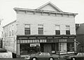
H. W. Harte Block – Crystal Falls Village Hall (demolished)
-
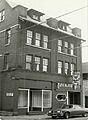
Cloverland Hotel (demolished)
-
Gottfried Hane House (destroyed by fire)
-
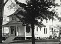
Lincoln School (demolished)
-
Donald C. MacKinnon House (demolished)
-
Beechwood Store (demolished)
-
Van Platen - Fox Lumber Camp Historic Complex (demolished)


