Island of Danna facts for kids
| Gaelic name | Danna |
|---|---|
| Meaning of name | Dane's island(Norse origin) |
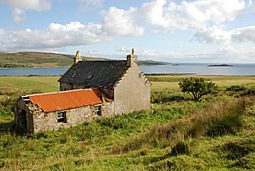
 An empty farm house on Island of Danna |
|
| OS grid reference | NR695785 |
| Coordinates | 55°56′N 5°41′W / 55.94°N 5.69°W |
| Physical geography | |
| Island group | Islay |
| Area | 315 ha (1+1⁄4 sq mi) |
| Area rank | 83 |
| Highest elevation | 54 m (177 ft) |
| Administration | |
| Sovereign state | United Kingdom |
| Country | Scotland |
| Council area | Argyll and Bute |
| Demographics | |
| Population | 1 |
| Population density | 0.3/km2 (0.78/sq mi) |
The Island of Danna or Danna (Scottish Gaelic: Danna) is a small island in Scotland. It is located in Argyll and Bute. Danna is special because it is a tidal island. This means you can walk to it from the mainland when the tide is low.
Island Life and Location
Danna is an inhabited island. It is connected to the mainland by a stone causeway. A causeway is like a raised road built across water. This causeway makes it easy to reach Danna.
The island sits at the southern end of the Tayvallich peninsula. This narrow strip of land separates two bodies of water: Loch Sween and the Sound of Jura. Danna is part of a larger area called the Knapdale National Scenic Area. These areas are protected because of their beautiful landscapes. There are 40 such areas in Scotland.
Nature and Wildlife
Danna is also part of the Ulva, Danna, and the MacCormaig Isles SSSI. An SSSI is a special place where nature is protected. These sites are important for their plants, animals, or geology. They help keep rare species and habitats safe.
The island's location between the loch and the sound creates a unique environment. This makes it a home for various types of wildlife. You might find different birds, marine life, and plants here. Exploring the island can be a great way to see Scotland's natural beauty.
 | Stephanie Wilson |
 | Charles Bolden |
 | Ronald McNair |
 | Frederick D. Gregory |

