
Nuyts Archipelago facts for kids
| Lua error in Module:Location_map at line 420: attempt to index field 'wikibase' (a nil value). | |
| Geography | |
|---|---|
| Location | Great Australian Bight |
| Administration | |
|
Australia
|
|
The Nuyts Archipelago is a group of islands in South Australia. It's located in the Great Australian Bight, which is a huge bay on Australia's southern coast. These islands are south of a town called Ceduna.
Most of the islands are made of granite rock. They are very important places for animals. Many Australian sea lions have their babies here. Also, lots of seabirds like short-tailed shearwaters build their nests on these islands. The group also includes smaller islands known as the Isles of St Francis. Most of the islands are protected areas, like the Nuyts Archipelago Wilderness Protection Area and the Nuyts Archipelago Conservation Park.
Contents
What is the Nuyts Archipelago?
There are about 30 islands and reefs in the Nuyts Archipelago. The islands furthest from the coast are called the Isles of St Francis. The largest island in this group is also called St Francis Island.
Most islands are made of a soft rock called calcarenite on top of harder granite. Near the sea, the waves have worn away the soft calcarenite rock.
This area is special for its wildlife in South Australia. This is because of the Leeuwin Current. This warm ocean current flows from west to east across the Great Australian Bight. It brings plants and animals usually found in western Australia. In this area, the warm Leeuwin Current mixes with the colder Flinders Current. This mix creates a "biodiversity hotspot", meaning there are many different kinds of living things here. For example, you can find special plate corals and fish like the Western Footballer here.
History of the Islands
The Nuyts Archipelago was named in 1802 by an explorer named Matthew Flinders. He named it after Pieter Nuyts. Pieter Nuyts was a Dutch official who sailed along Australia's southern coast in 1626–27. His ship, called 't Gulden Zeepaert, mapped the coastline from Albany to Ceduna. Pieter Nuyts was in the area of the islands in January 1627.
Both Matthew Flinders and another explorer, Nicolas Baudin, explored this area in 1802. They both gave names to several of the islands.
In the early 1800s, people used the islands and nearby coast for hunting seals and whaling. Whalers from Hobart set up stations on St Peter Island and in nearby bays.
Important Islands of the Archipelago
St Francis Island
St Francis Island was named in 1627. It is the second largest island in the archipelago, covering about 809 hectares. It has grasslands, saltbush, and low shrubs. Many muttonbirds (a type of seabird) live here. About 273,000 pairs of muttonbirds nest on this island. The highest point on the island is 81 meters above sea level. It has a lighthouse and a radio beacon. People used to farm on the island and mine for guano (bird droppings used as fertilizer).
Masillon Island
Masillon Island is about 2.5 kilometers south of St Francis Island. It was named in 1802 during Baudin’s expedition. The island has heathy shrubland and saltbush. About 39,520 pairs of muttonbirds live here.
Fenelon Island
Fenelon Island is about 1.5 kilometers south of Masillon Island. It was also named by Baudin. This island has heathland. It is home to a large number of white-faced storm petrels, with about 13,000 pairs. It also has a special place where Australian sea lions have their babies.
West Island
West Island is in the open ocean, about 1.5 kilometers west of St Francis Island. It has exposed granite rocks. Cape Barren geese use this island. It is also a breeding place for sea lions.
St Peter Island
St Peter Island is the largest and easiest island to reach in the archipelago. It is about 13 kilometers long and covers 3429 hectares. It has the most muttonbirds, with about 334,800 pairs. It is only 5 kilometers from the mainland. People farmed on this island from 1859 until 1988. Now, native plants are growing back, including patches of mallee woodland. It was named in 1627.
Franklin Islands
The Franklin Islands include East and West Franklin Islands. They are covered by nitre bush and have many breeding muttonbirds (102,080 pairs). Matthew Flinders named them in 1802 after John Franklin, who later became a famous explorer. These islands are joined by sand at low tide. Public access to the Franklin Islands is not allowed. This helps protect a special group of stick-nest rats that live there.
Other Amazing Animals
The Nuyts Archipelago is home to many other animals. You can find Tiger snakes and southern carpet pythons on the islands. Greater stick-nest rats live on the Franklin Islands. A special kind of southern brown bandicoot (Isoodon obesulus nauticus) lives only on St Francis and the Franklin Islands.
The archipelago is very important for Australian sea lions. There are eight places where they have their babies. They also have several "haul-out" sites where they rest on land. Southern fur seals also use these resting spots. Between May and October, southern right whales swim along the coast near the islands.
Protecting the Islands
Most of the islands in the Nuyts Archipelago are protected. They are part of the Nuyts Archipelago Wilderness Protection Area. This area was created in 2011 to keep the islands wild and safe. The waters around the islands are also protected as part of the Nuyts Archipelago Marine Park since 2012.
Important Bird Area
The Nuyts Archipelago is recognized as an Important Bird Area (IBA) by BirdLife International. This means it's a very important place for birds. It's home to more than 1% of the world's population of short-tailed shearwaters (about 890,740 breeding pairs). It also has many white-faced storm-petrels (22,750 breeding pairs) and pied oystercatchers (about 250 birds).
Other birds that nest here include little penguins, Pacific gulls, Caspian terns, and crested terns. You can also see eastern reef egrets, ospreys, white-bellied sea eagles, and hooded plovers. Rock parrots live on some of the islands too.
Images for kids
-
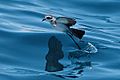
The archipelago is an important breeding site for white-faced storm petrels…
-
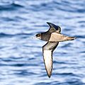
…short-tailed shearwaters…
-
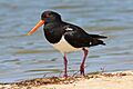
…and pied oystercatchers…
-
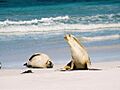
…as well as Australian sea lions


