
Izumo, Shimane facts for kids
Quick facts for kids
Izumo
出雲市
|
|||||||||||
|---|---|---|---|---|---|---|---|---|---|---|---|
|
|||||||||||
|
|||||||||||
 |
|||||||||||

Izumo
Location in Japan
|
|||||||||||
| Country | Japan | ||||||||||
| Region | Chūgoku (San'in) | ||||||||||
| Prefecture | Shimane | ||||||||||
| Area | |||||||||||
| • Total | 624.36 km2 (241.07 sq mi) | ||||||||||
| Population
(July 31, 2023)
|
|||||||||||
| • Total | 172,841 | ||||||||||
| • Density | 276.8291/km2 (716.984/sq mi) | ||||||||||
| Time zone | UTC+09:00 (JST) | ||||||||||
| City hall address | 109-1 Imaichichō, Izumo-shi, Shimane-ken 693-8530 | ||||||||||
| Climate | Cfa | ||||||||||
|
|||||||||||


Izumo (出雲市, Izumo-shi) is a cool city in Shimane Prefecture, Japan. As of July 2023, about 172,841 people live here. It covers an area of about 624 square kilometers. Izumo is famous for its ancient history and beautiful shrines.
Contents
Geography of Izumo
Izumo is located in the central eastern part of Shimane Prefecture. It is the second largest city in Shimane. Only Matsue has more people. Izumo is also the third largest city in the San'in region.
The city is built around the Izumo Plain. To the north, it touches the Shimane Peninsula and the Sea of Japan. To the south, it meets the Chugoku Mountains. The Hii River flows through the eastern part of the city. It empties into Lake Shinji. Izumo has many different landscapes. You can find seas, mountains, rivers, lakes, plains, canyons, and even hot springs here.
Neighboring Cities and Towns
Izumo shares borders with these places in Shimane Prefecture:
- Iinan
- Matsue
- Ōda
- Unnan
Climate in Izumo
Izumo has a humid subtropical climate. This means it has very warm summers. Winters are cool. It rains a lot throughout the year. July is usually the wettest month.
The average temperature in Izumo is about 14.9 degrees Celsius. August is the warmest month, with temperatures around 26.4 degrees Celsius. February is the coldest, at about 4.8 degrees Celsius. The hottest temperature ever recorded was 38.4 degrees Celsius in August 2017. The coldest was -12.5 degrees Celsius in February 2018.
| Climate data for Izumo (1991−2020 normals, extremes 1978−present) | |||||||||||||
|---|---|---|---|---|---|---|---|---|---|---|---|---|---|
| Month | Jan | Feb | Mar | Apr | May | Jun | Jul | Aug | Sep | Oct | Nov | Dec | Year |
| Record high °C (°F) | 20.8 (69.4) |
22.8 (73.0) |
25.1 (77.2) |
31.0 (87.8) |
31.1 (88.0) |
35.4 (95.7) |
37.3 (99.1) |
38.4 (101.1) |
37.4 (99.3) |
31.8 (89.2) |
26.4 (79.5) |
22.8 (73.0) |
38.4 (101.1) |
| Mean daily maximum °C (°F) | 8.4 (47.1) |
9.3 (48.7) |
12.7 (54.9) |
18.0 (64.4) |
22.8 (73.0) |
26.0 (78.8) |
29.5 (85.1) |
31.3 (88.3) |
27.1 (80.8) |
22.0 (71.6) |
16.5 (61.7) |
11.1 (52.0) |
19.6 (67.2) |
| Daily mean °C (°F) | 4.8 (40.6) |
5.1 (41.2) |
7.8 (46.0) |
12.6 (54.7) |
17.3 (63.1) |
21.2 (70.2) |
25.3 (77.5) |
26.4 (79.5) |
22.2 (72.0) |
16.7 (62.1) |
11.7 (53.1) |
7.2 (45.0) |
14.9 (58.8) |
| Mean daily minimum °C (°F) | 1.2 (34.2) |
0.7 (33.3) |
2.5 (36.5) |
6.6 (43.9) |
11.5 (52.7) |
16.7 (62.1) |
21.7 (71.1) |
22.4 (72.3) |
18.0 (64.4) |
11.7 (53.1) |
6.8 (44.2) |
3.1 (37.6) |
10.2 (50.5) |
| Record low °C (°F) | −6.5 (20.3) |
−8.4 (16.9) |
−4.0 (24.8) |
−3.2 (26.2) |
1.7 (35.1) |
7.4 (45.3) |
11.7 (53.1) |
15.0 (59.0) |
5.5 (41.9) |
2.3 (36.1) |
−0.9 (30.4) |
−3.6 (25.5) |
−8.4 (16.9) |
| Average precipitation mm (inches) | 121.6 (4.79) |
98.9 (3.89) |
123.5 (4.86) |
112.2 (4.42) |
130.3 (5.13) |
183.0 (7.20) |
229.8 (9.05) |
145.6 (5.73) |
187.1 (7.37) |
113.4 (4.46) |
114.6 (4.51) |
135.9 (5.35) |
1,675 (65.94) |
| Average precipitation days (≥ 1.0 mm) | 17.3 | 13.9 | 12.9 | 9.9 | 9.2 | 10.7 | 11.7 | 9.3 | 11.3 | 10.0 | 12.1 | 16.9 | 145.2 |
| Mean monthly sunshine hours | 53.9 | 80.3 | 140.4 | 186.1 | 208.8 | 164.2 | 178.5 | 207.9 | 152.5 | 155.3 | 107.3 | 65.4 | 1,697.4 |
| Source: Japan Meteorological Agency | |||||||||||||
| Climate data for Hikawa, Izumo (2003−2020 normals, extremes 2003−present) | |||||||||||||
|---|---|---|---|---|---|---|---|---|---|---|---|---|---|
| Month | Jan | Feb | Mar | Apr | May | Jun | Jul | Aug | Sep | Oct | Nov | Dec | Year |
| Record high °C (°F) | 18.0 (64.4) |
23.0 (73.4) |
25.2 (77.4) |
28.9 (84.0) |
31.7 (89.1) |
33.2 (91.8) |
36.1 (97.0) |
37.9 (100.2) |
36.2 (97.2) |
31.9 (89.4) |
27.4 (81.3) |
23.1 (73.6) |
37.9 (100.2) |
| Mean daily maximum °C (°F) | 8.1 (46.6) |
9.3 (48.7) |
12.8 (55.0) |
18.1 (64.6) |
23.2 (73.8) |
26.3 (79.3) |
29.7 (85.5) |
31.6 (88.9) |
27.3 (81.1) |
22.0 (71.6) |
16.7 (62.1) |
10.6 (51.1) |
19.6 (67.4) |
| Daily mean °C (°F) | 4.4 (39.9) |
5.1 (41.2) |
8.0 (46.4) |
12.8 (55.0) |
17.9 (64.2) |
21.8 (71.2) |
25.7 (78.3) |
27.1 (80.8) |
22.9 (73.2) |
17.2 (63.0) |
11.9 (53.4) |
6.7 (44.1) |
15.1 (59.2) |
| Mean daily minimum °C (°F) | 1.0 (33.8) |
1.0 (33.8) |
2.9 (37.2) |
7.3 (45.1) |
12.9 (55.2) |
18.0 (64.4) |
22.5 (72.5) |
23.4 (74.1) |
19.1 (66.4) |
12.5 (54.5) |
7.3 (45.1) |
3.0 (37.4) |
10.9 (51.6) |
| Record low °C (°F) | −6.1 (21.0) |
−12.5 (9.5) |
−3.5 (25.7) |
−0.9 (30.4) |
4.6 (40.3) |
9.7 (49.5) |
15.8 (60.4) |
16.5 (61.7) |
11.0 (51.8) |
4.5 (40.1) |
−0.3 (31.5) |
−3.1 (26.4) |
−12.5 (9.5) |
| Average precipitation mm (inches) | 120.5 (4.74) |
93.1 (3.67) |
118.8 (4.68) |
118.1 (4.65) |
126.4 (4.98) |
155.7 (6.13) |
241.0 (9.49) |
143.9 (5.67) |
183.7 (7.23) |
121.1 (4.77) |
112.2 (4.42) |
148.9 (5.86) |
1,690.8 (66.57) |
| Average precipitation days (≥ 1.0 mm) | 16.7 | 12.9 | 12.9 | 10.3 | 9.1 | 10.1 | 11.9 | 9.6 | 11.3 | 10.1 | 12.6 | 17.5 | 145 |
| Source: Japan Meteorological Agency | |||||||||||||
Population of Izumo
| Historical population | ||
|---|---|---|
| Year | Pop. | ±% |
| 1950 | 174,464 | — |
| 1955 | 175,419 | +0.5% |
| 1960 | 168,724 | −3.8% |
| 1965 | 161,790 | −4.1% |
| 1970 | 157,325 | −2.8% |
| 1975 | 159,058 | +1.1% |
| 1980 | 166,280 | +4.5% |
| 1985 | 170,529 | +2.6% |
| 1990 | 171,422 | +0.5% |
| 1995 | 172,001 | +0.3% |
| 2000 | 173,776 | +1.0% |
| 2005 | 173,751 | −0.0% |
| 2010 | 171,523 | −1.3% |
| 2015 | 171,938 | +0.2% |
| 2020 | 172,775 | +0.5% |
| Izumo population statistics | ||
The population of Izumo has stayed quite steady over the years. You can see how the number of people living in the city has changed in the table above.
History of Izumo
The Izumo area has a very long history. People have lived here since prehistoric times, which means before written records.
Ancient Discoveries
In 2009, archaeologists found some of the oldest stone tools in Japan near Izumo. These tools are about 120,000 years old! This discovery changed what we thought about when the first humans arrived in Japan. Later, scientists updated the age to 70,000 years.
During the Yayoi period (around 300 BC to 300 AD), a strong ancient kingdom grew in the Izumo Plain. We know this from old stories, ruins, and many items found from that time. There are also many large Kofun period (around 300 to 538 AD) burial mounds here. The Imaichi Dainenji Kofun, built in the 6th century, is the biggest in the Izumo region. It is 100 meters long!
From Feudal Lords to Modern City
During the Sengoku period (1467-1615), a time of civil war in Japan, the Amago clan controlled Izumo. But they were defeated by the Mōri clan. Later, during the Edo Period (1603-1868), the area was mostly ruled by the Matsue Domain.
After the Meiji restoration in 1868, Japan changed a lot. The town of Imaichi was created in 1889. Then, in 1941, Imaichi joined with eight nearby villages to form the town of Izumo. Less than a year later, Izumo officially became a city.
Recent Mergers
Izumo has grown bigger over time by joining with other towns.
- In 2005, Izumo absorbed the city of Hirata and the towns of Koryō, Sada, Taisha, and Taki.
- In 2011, the town of Hikawa also joined Izumo. Because of this, the Hikawa District no longer exists.
Economy of Izumo
The main jobs in Izumo are in farming and commercial fishing. Many people also work in tourism. Izumo is a popular place for visitors in the San'in region.
Education in Izumo
Izumo has many schools for young people.
- The city government runs 36 public elementary schools.
- There are 14 public junior high schools.
- The Shimane Prefectural Board of Education operates six public high schools.
- Izumo also has two private high schools.
- There is one special education school for students with disabilities.
Transportation in Izumo
Getting around Izumo and to other places is easy with different types of transport.
Airport
- Izumo Airport is the local airport.
Railway

You can travel by train using two main railway lines:
 JR West (JR West) - San'in Main Line
- Tagi - Oda - Kōnan - Izumo-Jinzai - Nishi-Izumo - Izumoshi - Naoe - Shōbara
 Ichibata Electric Railway (Bataden) - Kita-Matsue Line
- Dentetsu-Izumoshi - Izumo Science Center Park Town Mae - Ōtsumachi - Takeshi - Kawato - Ōtera - Midami - Tabushi - Unshū-Hirata - Nunozaki - Koyūkan-Shineki - Sono - Ichibataguchi - Inonada
- Ichibata Electric Railway (Bataden) - Taisha Line
- Kawato - Takahama - Yōkan - Hamayamakōen-Kitaguchi - Izumo Taisha-mae
Highways
Major roads connect Izumo to other parts of Japan:
 San'in Expressway
 National Route 9
 National Route 184
 National Route 431
Sister Cities of Izumo
Izumo has special friendships with cities around the world. These are called "sister city" relationships.
 Santa Clara, California, United States (since 1986)
 Hanzhong, China (since 1996)
 Évian-les-Bains, France (since 2002)
 Kalajoki, Finland (since 2003)
 Dún Laoghaire, Ireland (since 2008)
Local Attractions in Izumo
Izumo has many interesting places to visit.
- Izumo Taisha is one of the oldest and most important Shinto shrines in Japan. It is a very sacred place. In 2008, parts of the shrine were open to the public for a short time before big renovation work began. The nearby Shimane Museum of Ancient Izumo has many old items from the area.
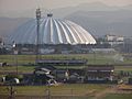
- Izumo Dome is a huge building north of the city. It is Japan's largest wooden building! It stands 49 meters high and is 143 meters wide. It is used for sports like baseball and soccer. It also hosts other events, including sumo wrestling. You can see it from far away, even from a train.
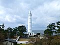
- Hinomisaki Lighthouse (日御碕灯台) is a modern stone lighthouse. It has a very powerful light. From the top, you can see the Oki Islands. These islands are famous from the old story of the "white rabbit."
- Shimane Winery is known for making very sweet wines.
- "Kirara Taki" Beach is a beautiful beach in the town of Taki. Taki joined Izumo in 2005. The beach has clean water. There are concrete blocks offshore to help break the waves. Close by, you can find an onsen (hot spring) called Marine Thalasso Izumo.
- The Okuizumo Museum of Tatara and Sword-making shows how traditional Japanese swords were made. They have demonstrations twice a month. One show is about how swords are forged. The other shows how they are used.
- The Izumo Handicraft Museum is located in old Japanese workshops. It shows traditional crafts.
Images for kids
-
Izumo Dome
-
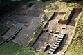
Kojindani archaeological site
-
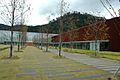
Shimane Prefectural Izumo Ancient Museum
-
Hinomisaki Lighthouse


See also
 In Spanish: Izumo (Shimane) para niños
