
Blairstown, New Jersey facts for kids
Quick facts for kids
Blairstown, New Jersey
|
||
|---|---|---|
|
Township
|
||

Blair Lake Spillway and Footbridge in October 2020
|
||
|
||

Location of Blairstown Township in Warren County highlighted in yellow (right). Inset map: Location of Warren County in New Jersey highlighted in black (left).
|
||

Census Bureau map of Blairstown, New Jersey
|
||

Blairstown, New Jersey
Location in Warren County, New Jersey

Blairstown, New Jersey
Location in New Jersey

Blairstown, New Jersey
Location in the United States
|
||
| Country | ||
| State | ||
| County | ||
| Incorporated | April 14, 1845 | |
| Named for | John Insley Blair | |
| Government | ||
| • Type | Township | |
| • Body | Township Committee | |
| Area | ||
| • Total | 30.78 sq mi (79.71 km2) | |
| • Land | 29.89 sq mi (77.41 km2) | |
| • Water | 0.89 sq mi (2.30 km2) 2.88% | |
| Area rank | 87th of 565 in state 2nd of 22 in county |
|
| Elevation | 364 ft (111 m) | |
| Population
(2020)
|
||
| • Total | 5,704 | |
| • Estimate
(2023)
|
5,757 | |
| • Rank | 360th of 565 in state 7th of 22 in county |
|
| • Density | 190.9/sq mi (73.7/km2) | |
| • Density rank | 507th of 565 in state 15th of 22 in county |
|
| Time zone | UTC−05:00 (Eastern (EST)) | |
| • Summer (DST) | UTC−04:00 (Eastern (EDT)) | |
| ZIP Code |
07825
|
|
| Area code(s) | 908 | |
| FIPS code | 3404106160 | |
| GNIS feature ID | 0882317 | |
| Website | ||

Blairstown is a township in Warren County, New Jersey. A township is a type of local government area. In 2020, about 5,704 people lived here. This was a small decrease from 5,967 people in 2010.
This area was once called Smith's Mill. Later, it was known as Butts Bridge. This name came from a family who owned a bridge over the Paulins Kill river. Blairstown became an official township on April 14, 1845. It was named after John Insley Blair, a famous businessman.
Contents
About Blairstown's Location
Blairstown is located in the Kittatinny Valley. This valley is part of the larger Great Appalachian Valley. It stretches for about 700 miles from Canada to Alabama.
The township covers about 30.78 square miles (79.71 square kilometers). Most of this area is land, with a small part being water. Blairstown is bordered by other towns in Warren County. These include Frelinghuysen, Hardwick, Hope, and Knowlton townships.
Some smaller communities are also found within Blairstown. These include Blair Lake, Cedar Lake, Jacksonburg, Kalaroma, and Lake Susquehanna.
Population Changes Over Time
The number of people living in Blairstown has changed over many years. Here's how the population has grown and shrunk:
| Historical population | |||
|---|---|---|---|
| Census | Pop. | %± | |
| 1850 | 1,405 | — | |
| 1860 | 1,542 | 9.8% | |
| 1870 | 1,379 | −10.6% | |
| 1880 | 1,458 | 5.7% | |
| 1890 | 1,662 | 14.0% | |
| 1900 | 1,576 | −5.2% | |
| 1910 | 1,718 | 9.0% | |
| 1920 | 1,361 | −20.8% | |
| 1930 | 1,416 | 4.0% | |
| 1940 | 1,449 | 2.3% | |
| 1950 | 1,571 | 8.4% | |
| 1960 | 1,797 | 14.4% | |
| 1970 | 2,189 | 21.8% | |
| 1980 | 4,360 | 99.2% | |
| 1990 | 5,331 | 22.3% | |
| 2000 | 5,747 | 7.8% | |
| 2010 | 5,967 | 3.8% | |
| 2020 | 5,704 | −4.4% | |
| 2023 (est.) | 5,757 | −3.5% | |
| Population sources: 1850–1920 1850–1870 1850 1870 1880–1890 1890–1910 1910–1930 1940–2000 2000 2010 2020 |
|||
Schools in Blairstown
Students in Blairstown attend public schools run by the Blairstown Township School District. This district has one school, Blairstown Elementary School. It serves students from kindergarten through sixth grade. Students from Hardwick Township also attend this school.
For older students, from seventh to twelfth grade, they go to North Warren Regional High School. This high school is also in Blairstown. It serves students from Blairstown, Frelinghuysen, Hardwick, and Knowlton townships.
There is also a special school called Ridge and Valley Charter School. It focuses on Earth literacy and sustainable living. It's for students in kindergarten through eighth grade. Students from Blairstown can attend this school.
Another option is Warren County Technical School in Washington borough. This school is for high school students (grades 9-12). It offers special training programs.
A private boarding school, Blair Academy, is also in Blairstown. It was started in 1848 by John Insley Blair. Students from all over the world attend this school for grades 9-12.
Getting Around Blairstown
Roads and Highways

Blairstown has many roads for cars and trucks. About 85.92 miles of roads run through the township. Some are maintained by the local government, some by Warren County, and some by the state.
Interstate 80 passes through the southern part of Blairstown. It doesn't have exits directly in the township. You can get on it from nearby towns. Route 94 goes through the middle of Blairstown. County Route 521 is in the eastern part.
Airport
Blairstown Airport (1N7) is located southwest of the main town area. It's a small airport used by small planes and gliders.
Train History and Future

Blairstown has a history with trains. The Lackawanna Cut-Off was a fast train line built over 100 years ago. It ran through Blairstown. Passenger service stopped in 1970, and the tracks were removed later.
Now, there are plans to bring train service back to Blairstown. This is part of the Lackawanna Cut-Off Restoration Project. The old Blairstown train station buildings are still standing. Future plans include a stop at this station for trains going to the Poconos and Scranton, Pennsylvania.
Another train line, the Blairstown Railway, also served the area. It was built by John Insley Blair himself. This line later became part of the New York, Susquehanna & Western Railroad. Passenger service on this line stopped in 1935. Today, the path of this old railway is a long trail called the Paulinskill Valley Trail. It's about 26 miles long and is great for walking or biking.
Cool Places to Visit
- The Blairstown Historic District is a special area added to the National Register of Historic Places in 2007. It means the buildings and area are important to history.
- The Historic Blairstown Theater, also known as Roy's Hall, was built in 1913. It used to show silent movies. Today, it's a beautiful blue building on Main Street. It hosts live music, plays, classic movies, and community events.
- The Blairstown Museum is a place where you can learn about the township's history. It has over 2,000 items that show what life was like in Blairstown. You can even learn about John Insley Blair, who the town is named after.
Gallery
-
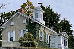
The Old Academy Building of the Blair Academy
-
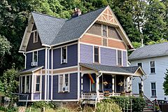
A house in the Blairstown Historic District
-
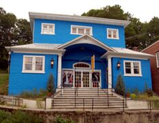
Historic Roy's Hall on Blairstown's Main Street
-
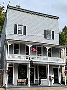
The Blairstown Museum


Famous People from Blairstown
Many interesting people have lived in or are connected to Blairstown:
- Cathy Bao Bean (born 1942), an author.
- Bennett Bean (born 1941), a skilled pottery artist.
- John Insley Blair (1802–1899), a very important businessman and railroad builder. The town is named after him!
- Anthony D'Amato (born 1987), a songwriter and singer.
- David T. Little (born 1978), a composer who writes music.
- Nancy Overton (1926–2009), a singer known for her work with The Chordettes.
- Lou Reed (1942–2013), a famous musician and songwriter.
See also
 In Spanish: Blairstown (Nueva Jersey) para niños
